Indaiatuba
| Indaiatuba | |||
|---|---|---|---|
| Municipality | |||
| Município de Indaiatuba Municipality of Indaiatuba | |||
|
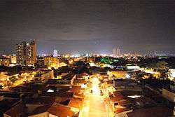
View of the city by night | |||
| |||
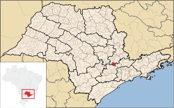 Location in the state of São Paulo | |||
 Indaiatuba Location in Brazil | |||
| Coordinates: 23°05′25″S 47°13′05″W / 23.09028°S 47.21806°WCoordinates: 23°05′25″S 47°13′05″W / 23.09028°S 47.21806°W | |||
| Country |
| ||
| Region | Southeast | ||
| State | São Paulo | ||
| Metropolitan Region | Campinas | ||
| Founded | December 9, 1830 | ||
| Government | |||
| • Mayor | Reinaldo Nogueira Lopes Cruz (PMDB) | ||
| Area | |||
| • Total | 311.55 km2 (120.29 sq mi) | ||
| Elevation | 624 m (2,047 ft) | ||
| Population (2015)[1] | |||
| • Total | 231,033 | ||
| • Density | 740/km2 (1,900/sq mi) | ||
| Time zone | BRT (UTC−3) | ||
| • Summer (DST) | BRST (UTC−2) | ||
| Website | Indaiatuba.sp.gov.br | ||
Indaiatuba is a municipality in the state of São Paulo in Brazil. It is part of the Metropolitan Region of Campinas.[2] The population is 231,033 (2015 est.) in an area of 311.55 km².[1] The elevation is 624 m. The city's name derives from the Tupi language. It is an important city in one of Brazil's main industrial regions.
Based on the latest IFDM social index data, Indaiatuba ranks number one of the "Top 100 best cities to live in, in Brazil".
The Federation of Industries of Rio de Janeiro, surveyed data and compared information on education, health, income and employment (wage and average generation of formal jobs) of all municipalities in the country and, with this data they created the Firjan Development Index Municipal (IFDM), so it was possible to create the rank of the top 100 cities to live in Brazil.
Data was collected from the Ministries of Education, Health and Labour for all municipalities.
References
External links
| Wikivoyage has a travel guide for Indaiatuba. |
| Wikimedia Commons has media related to Indaiatuba. |
- Indaiatuba Official Page (Portuguese)