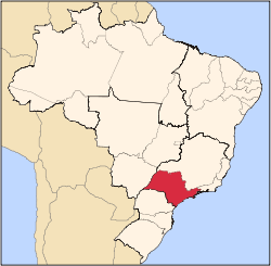
Catanduva is a municipality in the state of São Paulo, Brazil. The population is 119,480 (2015 est.) in an area of 290.59 km².[1] Is the second largest city in the Northern part of the state, after São José do Rio Preto. The city has a diversified economy, and the cultivation and processing of sugarcane is relevant.
Catanduva is the center of the microregion of Catanduva with 221,465 inhabitants, in an area of 2,283.6 km².[2]
History
The history of Catanduva begins in the middle of the 19th century, in lands that belonged to Araraquara and, posteriorly, originated the cities of Monte Alto, Jaboticabal and São José do Rio Preto. In the beginning of the 20th century, Catanduva was known as Cerradinho, a small village.
In December 16, 1909, the village was elevated to district, with the name of Vila Adolpho, and in April 14, 1918, the municipality of Catanduva was established.[3]

Mother Church of Catanduva.
The founders of Catanduva remain unknown, as there are two different histories. One of the versions tells that the small community of "Cerradinho", a little town built on the banks of the São Domingos river, was founded by the Figueiredo family, from Minas Gerais. The other famous version tells that the city was founded by Antônio Maximiano Rodrigues, also from Minas Gerais, who bought lands on the region, by the end of the 19th century. Later, part of these lands were donated to the São Domingos (Saint Dominic) parish.
Saint Dominic is the patron saint of Catanduva.[3]
Name
Catanduva (Caa-tã-dyba in Tupi-guarani language) is a word of indigenous origin meaning "rough grass" or "unhealthy vegetation".[4] It is a reference to the Brazilian Cerrado, the region's typical vegetation.
Geography
Weather
The climate is Tropical sub-hot humid (3 dry months), with dry and mild winters and hot, wet summers.[5] The average temperature of the coldest month is above 17 °C, and the average precipitation of the driest month is less than 60 mm. Its Köppen climate classification is Aw. The average annual temperature is 25.33 °C.
Hydrography
- São Domingos river
- Brook "Barro Preto"
- Brook "Fundo"
- Brook "Dos Coqueiros"
- Brook "Do retirinho"
- Brook "Jacu"
Economy
The economic basis of the city is the Tertiary sector. Commerce and services corresponds to 70.5% of the GDP. The Industry is responsible for 28.5% of the city GDP.[6] Mechanical fan is one of the main exported products of Catanduva. The cultivation and processing of sugarcane is relevant in the region.
Demographics
Indicators
All indicators are from SEADE[6] and IBGE[7]
Sports
Grêmio Catanduvense de Futebol is the city's professional football club. It replaced other now-defunct football clubs, Catanduva Esporte Clube, Grêmio Esportivo Catanduvense, Catanduva Esporte e Clube, and Clube Atlético Catanduvense. The city's stadium is the Estádio Municipal Sílvio Salles.
References
External links
|
|---|
|
|
|
|
|
| |
|---|
| Capital | |
|---|
| 1,000,000+ | |
|---|
| 500,000+ | |
|---|
| 200,000+ | |
|---|
| 100,000+ | |
|---|
|
|
|
| |
|---|
| São José do Rio Preto |
|---|
| Auriflama | |
|---|
| Catanduva | |
|---|
| Fernandópolis | |
|---|
| Jales | |
|---|
| Nhandeara | |
|---|
| Novo Horizonte | |
|---|
| São José do Rio Preto | |
|---|
| Votuporanga | |
|---|
|
|
|
|
|
|---|
|
|
|
| Araçatuba |
|---|
| Andradina | |
|---|
| Araçatuba | |
|---|
| Birigui | |
|---|
|
| |
|
|
|
|
|
| Bauru |
|---|
| Avaré | |
|---|
| Bauru | |
|---|
| Botucatu | |
|---|
| Jaú | |
|---|
| Lins | |
|---|
|
|
|
| Campinas |
|---|
| Amparo | |
|---|
| Campinas | |
|---|
| Mogi Mirim | |
|---|
| Pirassununga | |
|---|
| São João da Boa Vista | |
|---|
|
|
|
| Itapetininga |
|---|
| Capão Bonito | |
|---|
| Itapetininga | |
|---|
| Itapeva | |
|---|
| Tatuí | |
|---|
|
|
|
|
|
| Macro Metropolitana Paulista |
|---|
| Bragança Paulista | |
|---|
| Jundiaí | |
|---|
| Piedade | |
|---|
| Sorocaba | |
|---|
|
|
|
|
|
| Metropolitana de São Paulo |
|---|
| Franco da Rocha | |
|---|
| Guarulhos | |
|---|
| Itapecerica da Serra | |
|---|
| Mogi das Cruzes | |
|---|
| Osasco | |
|---|
| Santos | |
|---|
| São Paulo | |
|---|
|
|
|
| Piracicaba |
|---|
| Limeira | |
|---|
| Piracicaba | |
|---|
| Rio Claro | |
|---|
|
|
|
| Presidente Prudente |
|---|
| Adamantina | |
|---|
| Dracena | |
|---|
| Presidente Prudente | |
|---|
|
|
|
| Ribeirão Preto |
|---|
| Barretos | |
|---|
| Batatais | |
|---|
| Franca | |
|---|
| Ituverava | |
|---|
| Jaboticabal | |
|---|
| Ribeirão Preto | |
|---|
| São Joaquim da Barra | |
|---|
|
|
|
| São José do Rio Preto |
|---|
| Auriflama | |
|---|
| Catanduva | |
|---|
| Fernandópolis | |
|---|
| Jales | |
|---|
| Nhandeara | |
|---|
| Novo Horizonte | |
|---|
| São José do Rio Preto | |
|---|
| Votuporanga | |
|---|
|
|
|
| Vale do Paraíba Paulista |
|---|
| Bananal | |
|---|
| Campos do Jordão | |
|---|
| Caraguatatuba | |
|---|
| Guaratinguetá | |
|---|
| Paraibuna/Paraitinga | |
|---|
| São José dos Campos | |
|---|
|
|