São José do Rio Preto
| São José do Rio Preto | |||
|---|---|---|---|
| Municipality | |||
| Município de São José do Rio Preto | |||
|
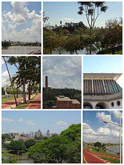
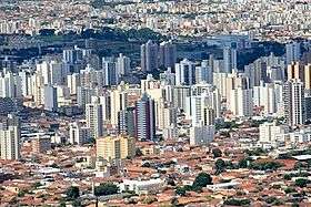
Views of the city | |||
| |||
| Nickname(s): Rio Preto | |||
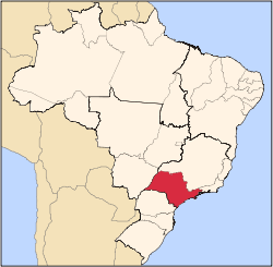
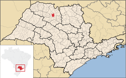 Location of São José do Rio Preto | |||
 São José do Rio Preto Location in Brazil | |||
| Coordinates: 20°48′29″S 49°22′52″W / 20.80806°S 49.38111°WCoordinates: 20°48′29″S 49°22′52″W / 20.80806°S 49.38111°W | |||
| Country |
| ||
| Region | Southeast | ||
| State |
| ||
| Mesoregion | São José do Rio Preto | ||
| Founded | March 19, 1852 | ||
| City Established | July 19, 1894 | ||
| Government | |||
| • Mayor | Valdomiro Lopes da Silva Junior (PSB) | ||
| Area | |||
| • Municipality | 431.30 km2 (166.53 sq mi) | ||
| • Urban | 117.43 km2 (45.34 sq mi) | ||
| Elevation | 489 m (1,604 ft) | ||
| Population (2010/IBGE) | |||
| • Municipality | 408,258 | ||
| • Density | 946.53/km2 (2,451.5/sq mi) | ||
| • Urban | 383,490 | ||
| Time zone | UTC-3 (UTC-3) | ||
| • Summer (DST) | UTC-2 (UTC-2) | ||
| Postal Code | 15000-000 | ||
| Area code(s) | +55 17 | ||
| Demonym | rio-pretense | ||
| Website | Prefecture of São José do Rio Preto | ||
| Editora Literatus | |||

São José do Rio Preto (Portuguese pronunciation: [sɐ̃w̃ ʒuˈzɛ du ʁiw ˈpɾetu]) is a municipality (cidade/município) in the state of São Paulo, Brazil. The city is located at the north/northwest portion of the state, 440 km (273 mi) from the city of São Paulo and 700 km (435 mi) from Brasília. With 408,258 inhabitants (IBGE/2010), is the 12th biggest city of the state and the 52nd biggest in Brazil.[1]
Founded in 1852, its history is closely linked with trade, the provision of services and agriculture. In 1912, the railroad Araraquarense arrived and stopped in the city for 20 years, transforming São José do Rio Preto in the commercial center of the region.
Known as Rio Preto, is the center of a Mesoregion with 1,569,220[2] inhabitants in 29,387 km². The Microregion of São José do Rio Preto has a population of 763,534 inhabitants.[3]
History
Before the 19th century, the region was inhabited by the Kaingang, an indigenous people, that was gradually reduced or assimilitated, due to migration, the bandeiras and miscegenation.[4] In the 19th century, farmers from Minas Gerais settled in the region.
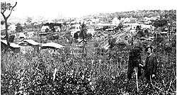
The city was founded on March 19, 1852, by João Bernardino de Seixas Ribeiro, after Luis Antônio da Silveira donated part of his lands to the Catholic Church, in tribute to Saint Joseph, aiming the creation of a city.[5] These lands from the farm gave birth to the city.
In 1894, São José do Rio Preto was officially established as a municipality, with the emancipation from Jaboticabal. The newly created city had around 26,000 km². With the arrival of the railroad, the Estrada de Ferro Araraquarense, in 1912, the city became the commercial center of the region, stocking and radiating the goods from the region and the state capital.[5]
Origin of the name
The literal translation is "Saint Joseph of the Black River". The city's name origin comes from the fact that Saint Joseph (São José) is the patron saint of the city, and the Rio Preto (Black river) cuts the city lands. A wooden sculpture of Saint Joseph wearing boots belongs to the city cathedral and no one knows for sure where it came from, but is in the city since it was a village in the 19th century, part of the city of Araraquara.[6]
People believe that migrants from the state of Minas Gerais brought the sculpture with them in the 19th century, and that is the origin of part of the name. The river was believed black because there was a dense forest in the area, and even though the water was clear, the darkness made the river looks black. March 19, Rio Preto's birthday, is Saint Joseph's Day and a holiday in the city.
Between 1906 and 1944, the name was shortened to "Rio Preto" and in 1944 there was a proposal for changing the city's name to "Iboruna" (Black river in Tupi language), but the name returned to the current form.[7]
Geography
| São José do Rio Preto | ||||||||||||||||||||||||||||||||||||||||||||||||||||||||||||
|---|---|---|---|---|---|---|---|---|---|---|---|---|---|---|---|---|---|---|---|---|---|---|---|---|---|---|---|---|---|---|---|---|---|---|---|---|---|---|---|---|---|---|---|---|---|---|---|---|---|---|---|---|---|---|---|---|---|---|---|---|
| Climate chart (explanation) | ||||||||||||||||||||||||||||||||||||||||||||||||||||||||||||
| ||||||||||||||||||||||||||||||||||||||||||||||||||||||||||||
| ||||||||||||||||||||||||||||||||||||||||||||||||||||||||||||
The city is located on the region between the rivers Grande, Paraná and Tietê. The Vegetation is a mixture of Cerrado (Grass savanna) with traces of the Mata Atlântica (Atlantic Forest). The topography is formed by a slightly undulated relief, with a medium elevation of 489 m (1,604 ft).[8]
Climate
According to the IBGE,[9] the clime is Tropical sub-hot humid, characterized by a mild and dry winter, and hot, rainy summers.
At the Köppen climate classification, the city is on a Cwa (Humid subtropical climate or Highland tropical) area, although the annual average temperature is of 23 °C. The annual average precipitation varies between 1,300 and 1,500 mm. In 2008, there were 1,593 mm of rain.[8]
Neighbouring cities
- North: Ipiguá and Onda Verde
- South: Cedral and Bady Bassitt
- East: Guapiaçu
- West: Mirassol
Economy
São José do Rio Preto is the biggest city of a region with strong agrarian tradition (Northwest of São Paulo). The city concentrates the Commerce and the specialized Service sector of the region. The Tertiary sector is the economic basis of the city. There are about 75 bank branches in the city. Hospitals, clinics, schools, universities, shopping centers (malls) and the commerce in general, attracts people from throughout the region and other parts of Brazil.
Agriculture and livestock (Primary sector) accounts for less than 1% of the GDP, but are relevant in the region.[8] Sugarcane, natural rubber, oranges and corn are the most cultivated.[8]
The Industry is formed by 3 major industrial districts, with the "Distrito Dr. Waldemar de Oliveira Verdi" being the biggest, and 13 smaller districts (mini distritos). There's a prevalence of small and medium businesses, with diversified production.
The GDP observed in 2009 was R$7,879,048,000.[10]
84.53% of the GDP is generated by the Tertiary sector and 15.19% by the Industry.[11]
Demographics
The HDI of the city, measured by the UNDP, was 0.834 in 2000, being 0.814 in Income, 0.916 in Education and 0.772 in Life expectancy.[12] The HDI for Brazil was 0.766 in the year 2000.[13] In 2008 there were 38 homicides in the city, making an homicide rate of 9.2/100 thousand inhabitants.[14]
| Populational Change[8] | |||
|---|---|---|---|
| Year | Population | ||
| 1960 | 84.039 | ||
| 1970 | 124.034 | ||
| 1980 | 188.601 | ||
| 1991 | 283.761 | ||
| 1996 | 323.368 | ||
| 2000 | 358.523 | ||
| 2010 | 408.258 | ||
| 2011[15] | 412.075 | ||
| 2012[16] | 415.769 | ||
The city has 2 districts: Engenheiro Schmitt, with 17,680 inhabitants (2009), and Talhado, with 4,502 inhabitants (2009).[8] São José do Rio Preto has about 360 neighbourhoods.
In 2010, the IBGE accounted 137,233 occupied and permanent households.[17]
Indicators
- Population: 408,258 (IBGE/2010)
- Area: 431.31 km² (166.5 sq mi)
- Urban area: 117.43 km² (45.3 sq mi)
- Population density: 946.53/km² (2,451.5/sq mi)
- Urbanization: 93.9% (2010)
- Sex ratio (Males to Females): 92.58 (2012)
- Birth rate: 12.63/1,000 inhabitants (2011)
- Infant mortality: 7.11/1,000 births (2011)
- Homicide rate: 9.2/100 thousand ppl[14]
- Literacy rate: 96.8 (2010)[18]
- HDI: 0.834 (UNDP/2000)
All indicators are from SEADE[11] and IBGE[1]
Other statistics
- Registered vehicles: 324,011 (Feb/2013)[19]
- Bank agencies: 82 (Febraban/2013)
- Mobile phones: 111.61%[20]
Culture
The major Library of the city is the Biblioteca Pública Municipal "Dr. Fernando Costa", a public institution, and the major theater is the Teatro Municipal "Humberto Sinibaldi Neto". There are other theater venues, like the Paulo Moura Theater, located at the old Swift factory, and the SESI Theater.
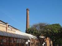
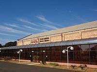
A vegetable oil factory from the 1940s, the "Swift", is a public cultural center since 1983, when it was bought by the prefecture.[21] In June, 2012, a new theater venue was opened at the "Swift", the Teatro Municipal "Paulo Moura", with 954 seats.[22]
Annually, on July, the city holds its popular "International Festival of Amateur Theater". Foreign and Brazilian theater groups join the Festival, in presentations throughout the city, in traditional theaters, as well as open air stages and other less traditional performance venues.[23]
Rodeos are popular throughout the region and the upstate, and Rio Preto has annual festivals of the genre.[24]
The city has a lively nightlife with many bars and clubs offering different styles of music. One of the most popular hotspots in Rio Preto is the Rock bar "Vila Dionísio", which show cases local acts as well as tribute bands and themed events. The city hosts annually a LGBT parade, the "Parada do Orgulho GLSBT de Rio Preto", gathering thousands of people from the all parts of Brazil.[25]
Media
Rio Preto has affiliates of the Rede Record and Rede Globo, and is the head office for Rede Vida (Life Network), a catholic television network with national presence. The city has a branch of the NET, a cable television operator.
There are two daily newspapers in the city, the Diário da Região[26] (Region's Diary) and the Bom Dia (Good Day).[27]
Urban structure
.jpg)
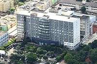
Health
There are 8 hospitals in São José do Rio Preto, with 1.681 beds.[8] The Hospital de Base, a public institution, is the biggest hospital of the city.
Education
The city has 36 state schools and 51 private schools, from infant to secondary education, and 153 municipal schools, from infant to primary education.[8] Rio Preto also has three public universities: a branch of the UNESP, called Ibilce,[28] the FAMERP,[29] specialized in Medicine, and the FATEC (Faculdades de Tecnologia do Estado de São Paulo). The city also has various private universities, such as Unirp, UNIP, Unorp, Unilago.
Urban transport
Rio Preto has 2 companies of mass urban transportation, the Circular Santa Luzia and the Expresso Itamarati. 300 buses operates daily, throughout the city.[8]
Infrastructure
- Households with enough space: 91.71% (2000)
- Households with adequate urban infrastructure: 95.48 (2000)
- Waste collection: 99.68% (2000)
- Water supply: 96.60 (2000)
All indicators are from SEADE[11]
Sports
There are two professional association football clubs in the city: América-SP and Rio Preto. América-SP usually plays at Teixeirão Stadium, which has a maximum capacity of 32,168 spectators.[30] Rio Preto plays at Rio Pretão Stadium, which has a maximum capacity of 17,000 spectators.[31]
The city has a number of public sport venues, including an arena with a capacity of 6,000 seated spectators, the "Centro Regional de Eventos" (Events Regional Center), 24 public football fields, an athletic track and bocce (bocha) courts.[8] There's a wheelchair basketball team in the city, formed by members of the CAD (Friends of Disabled persons Club), competing at national level. The CAD also competes in other disabled sports.[32]
Transportation
Roads
- Highway SP-310 "Rodovia Washington Luís", from the city of São Paulo (450 km) (280 mi)
- BR-153 "Rodovia Transbrasiliana", from Brasília (700 km) (435 mi)
- SP-425 "Rodovia Assis Chateaubriand", from Presidente Prudente (267 km) (165 mi)
- SP-427 "Rodovia Délcio Custódio da Silva" — 25 km to Mirassolândia
Air
São José do Rio Preto is served by "Prof. Eribelto Manoel Reino Airport".
International relations
Twin towns – Sister cities
External links
- (Portuguese) Prefecture's Official Site
- (Portuguese) UNESP/Ibilce - State University
- (Portuguese) Satellite images of Rio Preto
- (Portuguese) Airclub of Rio Preto
- (Portuguese) Newspaper Diário da Região
- (Portuguese) Newspaper Bom Dia
References
- 1 2 "Population at "Censo 2010"" (PDF) (in Portuguese). IBGE.gov.br. Retrieved 4 Jul 2011.
- ↑ Censo 2010 of the IBGE. Data found on http://www.ibge.gov.br/home/estatistica/populacao/censo2010/sinopse_tab_zip.shtm
- ↑ "2010 Census of the IBGE - Synopsis - Tables 761 and 1301 - Search" (in Portuguese). IBGE.gov.br. Retrieved 13 July 2011.
- ↑ "The advance in Kaingang lands of São Paulo's West." (in Portuguese). Portal Kaingang. Retrieved 8 July 2011.
- 1 2 "History on the Prefecture's Official Site" (in Portuguese). Riopreto.sp.gov.br. Retrieved 14 June 2011.
- ↑ "Historical Patrimony > Catedral de São José" (in Portuguese). Prefecture of São José do Rio Preto. Retrieved 18 August 2012.
- ↑ "Iboruna, 158 years" (in Portuguese). Diarioweb. 21 March 2010. Retrieved 10 July 2011.
- 1 2 3 4 5 6 7 8 9 10 "Economic Conjuncture of the City, 2010". Conjuntura econômica de São José do Rio Preto - 2010 (in Portuguese). Retrieved 15 June 2011.
- ↑ "Climate Map of Brazil" (PDF) (in Portuguese). IBGE. Retrieved 14 June 2011.
- ↑ "Gross Domestic Product of Municipalities 2009" (PDF) (in Portuguese). IBGE.gov.br. Retrieved 4 June 2012.
- 1 2 3 "Municipal Profile at SEADE" (in Portuguese). Fundação SEADE. Retrieved 5 July 2011.
- ↑ "Human Development Index, 1991 and 2000 - Municipalities" (in Portuguese). PNUD (UNDP) Brasil. Retrieved 6 July 2011.
- ↑ "Human Development Index, 1991 and 2000 - States of Brazil". Atlas do Desenvolvimento Humano no Brasil (in Portuguese). pnud.org.br. Retrieved 18 July 2011.
- 1 2 "Violence Map of Brazil". Mapa da Violência 2011 (in Portuguese). Retrieved 6 July 2011.
- ↑ "2011 Population Estimates - IBGE" (PDF). IBGE.gov.br. Retrieved 20 May 2012.
- ↑ "2012 Population Estimates - IBGE". IBGE.gov.br. Retrieved 4 April 2013.
- ↑ "2010 IBGE Census - SIDRA - Tables 3152 and 3157". IBGE.gov.br. Retrieved 18 July 2011.
- ↑ "Municipal Social Indicators IBGE 2010 - São Paulo state". 2010 Census of the IBGE. IBGE.gov.br. Retrieved 17 November 2011.
- ↑ "February 2013 Fleet - Denatran" (in Portuguese). Denatran.gov.br. Retrieved 8 April 2013.
- ↑ "Brasil fecha maio com mais de 215 milhões de acessos móveis" (in Portuguese). Anatel.gov.br. 17 June 2011. Retrieved 10 July 2011.
- ↑ "Historical Patrimony > Swift" (in Portuguese). Prefecture of São José do Rio Preto. Retrieved 2 April 2012.
- ↑ "Teatro Municipal "Paulo Moura" será inaugurado amanhã" (in Portuguese). Diário da Região. 20 June 2012. Retrieved 24 June 2012.
- ↑ "Festival Internacional de Teatro de São José do Rio Preto". Retrieved 14 June 2011.
- ↑ "Rio Preto Rodeo Country Bulls". Countrybulls.com.br. Retrieved 5 July 2011.
- ↑ "Parada LGBTS espera reunir cerca de 80 mil pessoas" (in Portuguese). Diarioweb. Retrieved 5 July 2011.
- ↑ "Newspaper "Diário da Região"". Retrieved 10 July 2011.
- ↑ "Newspaper "Bom Dia"". Retrieved 10 July 2011.
- ↑ "Unesp Rio Preto". Retrieved 15 June 2011.
- ↑ "Famerp Rio Preto". Retrieved 15 June 2011.
- ↑ "Capacidade dos estádios da A-2" (in Portuguese). Futebol Interior. Retrieved 6 July 2011.
- ↑ "Riopretão - Estádio "Anísio Haddad"" (in Portuguese). Riopretoec.blogspot.com. Retrieved 6 July 2011.
- ↑ "CAD (Friends of Disabled persons Club)" (in Portuguese). Cad.org.br. Retrieved 7 July 2011.
| Wikimedia Commons has media related to São José do Rio Preto. |
Capital: São Paulo | |||||||||||||||||||||||||||||||||||||
|  | ||||||||||||||||||||||||||||||||||||
|
| |||||||||||||||||||||||||||||||||||||
| |||||||||||||||||||||||||||||||||||||
| |||||||||||||||||||||||||||||||||||||
| |||||||||||||||||||||||||||||||||||||
| |||||||||||||||||||||||||||||||||||||
| |||||||||||||||||||||||||||||||||||||
| |||||||||||||||||||||||||||||||||||||
| |||||||||||||||||||||||||||||||||||||
| |||||||||||||||||||||||||||||||||||||
| |||||||||||||||||||||||||||||||||||||
| |||||||||||||||||||||||||||||||||||||
| |||||||||||||||||||||||||||||||||||||