Aubencheul-aux-Bois
| Aubencheul-aux-Bois | |
|---|---|
|
Entrance to the village | |
 Aubencheul-aux-Bois | |
|
Location within Hauts-de-France region  Aubencheul-aux-Bois | |
| Coordinates: 50°01′46″N 3°15′56″E / 50.0294°N 3.2656°ECoordinates: 50°01′46″N 3°15′56″E / 50.0294°N 3.2656°E | |
| Country | France |
| Region | Hauts-de-France |
| Department | Aisne |
| Arrondissement | Saint-Quentin |
| Canton | Le Catelet |
| Intercommunality | Pays du Vermandois |
| Government | |
| • Mayor (1977–2020) | Francis Passet |
| Area1 | 2.11 km2 (0.81 sq mi) |
| Population (2012)2 | 298 |
| • Density | 140/km2 (370/sq mi) |
| Time zone | CET (UTC+1) |
| • Summer (DST) | CEST (UTC+2) |
| INSEE/Postal code | 02030 / 02420 |
| Elevation | 105–139 m (344–456 ft) |
|
1 French Land Register data, which excludes lakes, ponds, glaciers > 1 km² (0.386 sq mi or 247 acres) and river estuaries. 2 Population without double counting: residents of multiple communes (e.g., students and military personnel) only counted once. | |
_city_limit_sign.JPG)
Aubencheul-aux-Bois is a French commune in the department of Aisne in the Hauts-de-France region of northern France.
The inhabitants of the commune are known as Aubencheulois or Aubencheuloises[1]
Geography
Aubencheul-aux-Bois is located some 20 km south of Cambrai and 30 km east of Combles. The north-west border of the commune is the border between Aisne and Nord departments. The D644 road from La Gaite in the north runs south along the western border of the commune changing to D1044 in the commune and continuing south to Le Catelet. The D16 road runs east from the D644 to the village changing to D281 within the commune then continuing east as the D16 to Villers-Outreaux. The commune is composed entirely of farmland.[2]
Two streams rise in the commune - one flowing south-west and the other flowing east.[2]
Neighbouring communes and villages[2]
 |
Honnecourt-sur-Escaut | Montecouvez | | |
| Ossu | |
Villers-Outreaux | ||
| ||||
| | ||||
| Vendhuile | Gouy | Beaurevoir |
History
_monument_aux_morts.JPG)
_oratoire.JPG)
Aubencheul-aux-Bois was the seat of a small abbey founded in the 11th century in the middle of the forest of Arrouaise. It was part of the province of Cambrésis. The village was ravaged in 1584 by the Duke of Parma and in 1636 by the Spaniards. The first inhabitants back to 1663 were the families of Loubry, Lévêque, Grau, Deboucq, Dessains, Dessenne, Guéguin, Carpentier, Milhem, Ferlier, Fichaux, Bernerd, Biar, Simon, Val, Bancourt, Noblécourt, Dubois, Caré, Faucon, Dazin, Savary, Malézieux, Lanthoine, Coupé, Pattée, Dambraine, Gressier, Thibaut, Billon, Domont, and Bantigny. On 16 July 1735, after five days of strong winds, a swarm of grasshoppers destroyed the stocks of straw and hay. There was a shortage in 1709 due to the freezing conditions from January to March with most fruit trees and corn crop being destroyed. This happened again in 1740 when poverty was extreme until the end of harvest in 1741 - during the famine the population lost about a quarter of its population. On 15 June 1839 a tornado a mile wide with hail as large as chicken eggs arrived and everything was destroyed. A fire destroyed 63 houses on 17 June 1827. In 1848 there was famine, in 1849 Cholera. The village was almost completely destroyed during the First World War.
Administration
List of Successive Mayors of Aubencheul-aux-Bois[3]
| From | To | Name | Party | Position |
|---|---|---|---|---|
| 1708 | Louys Caron | Mayor | ||
| 1740 | 1742 | Henri Caron | Mayor | |
| 1751 | 1755 | Paul Passé | Mayor | |
| 1758 | 1765 | Alexandre Dominique Passet | Mayor | |
| 1773 | Michel Carron | Mayor | ||
| 1776 | Philippe Joseph Caron | Mayor | ||
| 1786 | 1788 | Charles Joseph Passet | ||
| 1792 | Antoine Joseph Millot | |||
| 1792 | Maximilien Caré | Mayor | ||
| 1800 | 1816 | Hyacinthe Passet | ||
| 1816 | 1831 | Augustin Passet | ||
| 1832 | 1836 | Noël Milhem | ||
| 1836 | 1847 | Ildefonce Désiré Passet | ||
| 1848 | 1861 | Charles Clavier | ||
| 1861 | 1871 | Benoît Hyacinthe Passet | ||
| 1871 | 1871 | Louis Lévêque | ||
| 1871 | 1875 | Eugéne Loubry | ||
| 1875 | 1878 | Simon Philemont | ||
| 1878 | 1892 | Eugéne Loubry | ||
| 1892 | 1896 | Ernest Fontaine | ||
| 1896 | 1904 | Charles Passet | ||
| 1904 | Ernest Passet | |||
| 1954 | Lucien Passet | |||
| 1977 | 2020 | Francis Passet | DVD |
(Not all data is known)
Demography
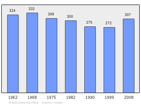
In 2012 the commune had 298 inhabitants. The evolution of the number of inhabitants is known through the population censuses conducted in the town since 1793. From the 21st century, a census of municipalities with fewer than 10,000 inhabitants is held every five years, unlike larger towns that have a sample survey every year.[Note 1]
| 1793 | 1800 | 1806 | 1821 | 1831 | 1836 | 1841 | 1846 | 1851 |
|---|---|---|---|---|---|---|---|---|
| 629 | 570 | 553 | 551 | 661 | 686 | 715 | 726 | 729 |
| 1856 | 1861 | 1866 | 1872 | 1876 | 1881 | 1886 | 1891 | 1896 |
|---|---|---|---|---|---|---|---|---|
| 730 | 742 | 764 | 785 | 785 | 741 | 743 | 710 | 702 |
| 1901 | 1906 | 1911 | 1921 | 1926 | 1931 | 1936 | 1946 | 1954 |
|---|---|---|---|---|---|---|---|---|
| 644 | 601 | 606 | 410 | 409 | 370 | 343 | 295 | 328 |
| 1962 | 1968 | 1975 | 1982 | 1990 | 1999 | 2006 | 2007 | 2010 |
|---|---|---|---|---|---|---|---|---|
| 324 | 332 | 309 | 300 | 275 | 272 | 301 | 305 | 310 |
Sources : Ldh/EHESS/Cassini until 1962, INSEE database from 1968 (population without double counting and municipal population from 2006)
_croix_de_chemin.JPG)
Sites and Monuments
_%C3%A9glise.JPG)
- A Church, rebuilt after the 1914-18 war in a neo-Romanesque style mostly in brick.
See also
External links
- Aubencheul-aux-Bois on the old IGN website (French)
- Aubencheul-aux-Bois on Lion1906
- Aubencheul-aux-Bois on Google Maps
- Aubencheul-aux-Bois on Géoportail, National Geographic Institute (IGN) website (French)
- Aubancheul aux Bois on the 1750 Cassini Map
- Aubencheul-aux-Bois on the INSEE website (French)
- INSEE (French)
Notes and references
Notes
- ↑ At the beginning of the 21st century, the methods of identification have been modified by law No. 2002-276 of 27 February 2002 , the so-called "law of local democracy" and in particular Title V "census operations" which allow, after a transitional period running from 2004 to 2008, the annual publication of the legal population of the different French administrative districts. For municipalities with a population greater than 10,000 inhabitants, a sample survey is conducted annually, the entire territory of these municipalities is taken into account at the end of the period of five years. The first "legal population" after 1999 under this new law came into force on 1 January 2009 and was based on the census of 2006.
References
- ↑ Inhabitants of Aisne (French)
- 1 2 3 Google Maps
- ↑ List of Mayors of France (French)
| Wikimedia Commons has media related to Aubencheul-aux-Bois. |