Guny
| Guny | |
|---|---|
 | |
 Guny | |
|
Location within Hauts-de-France region  Guny | |
| Coordinates: 49°31′11″N 3°16′06″E / 49.5197°N 3.2683°ECoordinates: 49°31′11″N 3°16′06″E / 49.5197°N 3.2683°E | |
| Country | France |
| Region | Hauts-de-France |
| Department | Aisne |
| Arrondissement | Laon |
| Canton | Coucy-le-Château-Auffrique |
| Intercommunality | Val de l'Ailette |
| Government | |
| • Mayor (2008–2014) | Éliane Tourigny |
| Area1 | 9.32 km2 (3.60 sq mi) |
| Population (2008)2 | 437 |
| • Density | 47/km2 (120/sq mi) |
| Time zone | CET (UTC+1) |
| • Summer (DST) | CEST (UTC+2) |
| INSEE/Postal code | 02363 / 02300 |
| Elevation |
42–152 m (138–499 ft) (avg. 70 m or 230 ft) |
|
1 French Land Register data, which excludes lakes, ponds, glaciers > 1 km² (0.386 sq mi or 247 acres) and river estuaries. 2 Population without double counting: residents of multiple communes (e.g., students and military personnel) only counted once. | |
Guny is a commune in the Aisne department in Hauts-de-France in northern France.
History
In 858, Guny's village is given to the abbey of Notre-Dame of Soissons by Charles the Bold.
In 1368, Enguerrand VII of Coucy grants the collectivity franchise to Guny and twenty-two other churches.
1914-1918, World War I devastated the village. From August 27 until September 28, the 11th and 20th infantry fight Battle of Ailette around Guny's quarries.
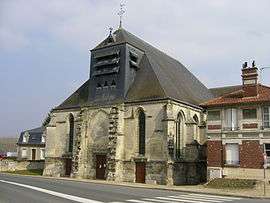
Saint Georges' church is destroyed. It was restored in 1923.
A new bell was inaugurated in November 1923, in a temporary church.
Geography
The river Ailette forms all of the commune's northeastern border.
Population
| Historical population | ||
|---|---|---|
| Year | Pop. | ±% |
| 1962 | 580 | — |
| 1968 | 562 | −3.1% |
| 1975 | 594 | +5.7% |
| 1982 | 549 | −7.6% |
| 1990 | 508 | −7.5% |
| 1999 | 447 | −12.0% |
| 2008 | 437 | −2.2% |
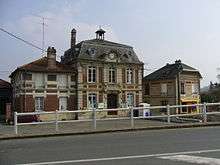
Town hall
See also
References
| Wikimedia Commons has media related to Guny. |
This article is issued from Wikipedia - version of the 11/8/2016. The text is available under the Creative Commons Attribution/Share Alike but additional terms may apply for the media files.