Barenton-Bugny
| Barenton-Bugny | |
|---|---|
 | |
 Barenton-Bugny | |
|
Location within Hauts-de-France region  Barenton-Bugny | |
| Coordinates: 49°38′02″N 3°39′08″E / 49.6339°N 3.6522°ECoordinates: 49°38′02″N 3°39′08″E / 49.6339°N 3.6522°E | |
| Country | France |
| Region | Hauts-de-France |
| Department | Aisne |
| Arrondissement | Laon |
| Canton | Crécy-sur-Serre |
| Intercommunality | Pays de la Serre |
| Government | |
| • Mayor (2014–2020) | Gérard Bourez |
| Area1 | 11.38 km2 (4.39 sq mi) |
| Population (2010)2 | 589 |
| • Density | 52/km2 (130/sq mi) |
| Time zone | CET (UTC+1) |
| • Summer (DST) | CEST (UTC+2) |
| INSEE/Postal code | 02046 / 02000 |
| Elevation | 64–96 m (210–315 ft) |
|
1 French Land Register data, which excludes lakes, ponds, glaciers > 1 km² (0.386 sq mi or 247 acres) and river estuaries. 2 Population without double counting: residents of multiple communes (e.g., students and military personnel) only counted once. | |
Barenton-Bugny is a French commune in the department of Aisne in the Hauts-de-France region of northern France.
The inhabitants of the commune are known as Barentonais or Barentonaises[1]
Geography
Barenton-Bugny is located some 5 km north by north-west of Laon and 8 km south of Crecy-sur-Serre. The Autoroute des Anglais (A26 autoroute) passes through the commune and there is an exit just south of the commune to National Highway N2 which passes north-east though the commune. From National Highway N2 the commune can be accessed on road D546 going north to the village then continuing north-west to intersect the D545 going north to Barenton-Cel. The D513 also goes east from the village to Monceau-le-Waast. There is also the D967 road which passes north-south through the western edge of the commune. Apart from the village and a few patches of forest the commune is entirely farmland with no other villages or hamlets.[2]
The north-western border of the commune is delineated by the Ruisseau de Longedeau which flows into the Ru des Barentons and continues north changing its name a few times before joining the Souche river.[2]
Neighbouring communes and villages[2]
 |
Chery-les-Pouilly | Barenton-Cel | Grandlup-et-Fay | |
| Vivaise | |
Monceau-le-Waast | ||
| ||||
| | ||||
| Aulnois-sous-Laon | Chambry | Samoussy |
Administration
List of Successive Mayors of Barenton-Bugny[3]
| From | To | Name | Party | Position |
|---|---|---|---|---|
| 2001 | 2014 | Michel Batteux | DVG | |
| 2014 | 2020 | Gérard Bourez |
(Not all data is known)
Demography
In 2010 the commune had 589 inhabitants. The evolution of the number of inhabitants is known through the population censuses conducted in the commune since 1793. From the 21st century, a census of municipalities with fewer than 10,000 inhabitants is held every five years, unlike larger towns that have a sample survey every year.[Note 1]
| 1793 | 1800 | 1806 | 1821 | 1831 | 1836 | 1841 | 1846 | 1851 |
|---|---|---|---|---|---|---|---|---|
| 289 | 328 | 383 | 460 | 618 | 647 | 653 | 710 | 710 |
| 1856 | 1861 | 1866 | 1872 | 1876 | 1881 | 1886 | 1891 | 1896 |
|---|---|---|---|---|---|---|---|---|
| 735 | 673 | 702 | 703 | 717 | 646 | 644 | 658 | 645 |
| 1901 | 1906 | 1911 | 1921 | 1926 | 1931 | 1936 | 1946 | 1954 |
|---|---|---|---|---|---|---|---|---|
| 558 | 564 | 514 | 519 | 536 | 559 | 548 | 603 | 554 |
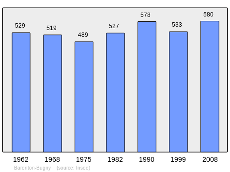
| 1962 | 1968 | 1975 | 1982 | 1990 | 1999 | 2006 | 2008 | 2010 |
|---|---|---|---|---|---|---|---|---|
| 529 | 519 | 489 | 527 | 578 | 533 | 570 | 580 | 589 |
Sources : Ldh/EHESS/Cassini until 1962, INSEE database from 1968 (population without double counting and municipal population from 2006)

Sites and Monuments
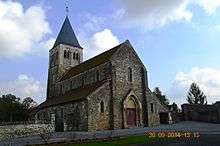
- The Church of Saint Martin (12th century)
 is registered as an historical monument.[4]
- Picture Gallery
-

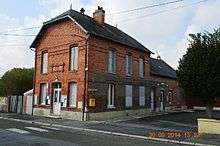
Barenton-Bugny Railway Station
-
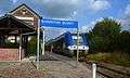
A train at Barenton-Bugny Railway Station
Notable People linked to the commune
- René Blondelle, Senator for Aisne and one of the largest postwar farmers in Barenton-Bugny.
See also
External links
- Barenton-Bugny on the old IGN website (French)
- Bell Towers website (French)
- 40000 Bell Towers website (French)
- Barenton-Bugny on Lion1906
- Barenton-Bugny on Google Maps
- Barenton-Bugny on Géoportail, National Geographic Institute (IGN) website (French)
- Baranton Bugny on the 1750 Cassini Map
- Barenton-Bugny on the INSEE website (French)
- INSEE (French)
Notes and references
Notes
- ↑ At the beginning of the 21st century, the methods of identification have been modified by law No. 2002-276 of 27 February 2002 , the so-called "law of local democracy" and in particular Title V "census operations" which allow, after a transitional period running from 2004 to 2008, the annual publication of the legal population of the different French administrative districts. For municipalities with a population greater than 10,000 inhabitants, a sample survey is conducted annually, the entire territory of these municipalities is taken into account at the end of the period of five years. The first "legal population" after 1999 under this new law came into force on 1 January 2009 and was based on the census of 2006.
References
- ↑ Inhabitants of Aisne (French)
- 1 2 3 Google Maps
- ↑ List of Mayors of France (French)
- ↑ Ministry of Culture, Mérimée PA00115517 Church of Saint Martin (French)
| Wikimedia Commons has media related to Barenton-Bugny. |