Bellicourt
| Bellicourt | |
|---|---|
|
St. Quentin Canal | |
 Bellicourt | |
|
Location within Hauts-de-France region  Bellicourt | |
| Coordinates: 49°57′42″N 3°14′12″E / 49.9617°N 3.2367°ECoordinates: 49°57′42″N 3°14′12″E / 49.9617°N 3.2367°E | |
| Country | France |
| Region | Hauts-de-France |
| Department | Aisne |
| Arrondissement | Saint-Quentin |
| Canton | Le Catelet |
| Intercommunality | Pays du Vermandois |
| Government | |
| • Mayor (2008–2014) | Marcel Leclere |
| Area1 | 9.77 km2 (3.77 sq mi) |
| Population (2012)2 | 632 |
| • Density | 65/km2 (170/sq mi) |
| Time zone | CET (UTC+1) |
| • Summer (DST) | CEST (UTC+2) |
| INSEE/Postal code | 02065 / 02420 |
| Elevation |
94–194 m (308–636 ft) (avg. 132 m or 433 ft) |
|
1 French Land Register data, which excludes lakes, ponds, glaciers > 1 km² (0.386 sq mi or 247 acres) and river estuaries. 2 Population without double counting: residents of multiple communes (e.g., students and military personnel) only counted once. | |
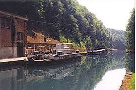
Bellicourt is a commune in the department of Aisne in Hauts-de-France in northern France.
It lies on the N44 road between Cambrai and Saint-Quentin and over the principal tunnel of the St. Quentin Canal.
It was the site of numerous intense combat actions and battles during World War I.
Population
| Historical population | ||
|---|---|---|
| Year | Pop. | ±% |
| 1962 | 609 | — |
| 1968 | 624 | +2.5% |
| 1975 | 607 | −2.7% |
| 1982 | 640 | +5.4% |
| 1990 | 664 | +3.8% |
| 1999 | 680 | +2.4% |
| 2008 | 638 | −6.2% |
| 2012 | 632 | −0.9% |
See also
References
| Wikimedia Commons has media related to Bellicourt. |
This article is issued from Wikipedia - version of the 11/8/2016. The text is available under the Creative Commons Attribution/Share Alike but additional terms may apply for the media files.