Bairdsville, New Jersey
| Bairdsville, New Jersey | |
|---|---|
| Unincorporated community | |
|
County Route 527A southbound, approaching Baird Road | |
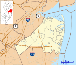 Bairdsville, New Jersey  Bairdsville, New Jersey  Bairdsville, New Jersey Location of Bairdsville in Monmouth County Inset: Location of county within the state of New Jersey | |
| Coordinates: 40°14′31″N 74°23′02″W / 40.24194°N 74.38389°WCoordinates: 40°14′31″N 74°23′02″W / 40.24194°N 74.38389°W | |
| Country |
|
| State |
|
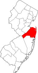
| County | Monmouth |
| Township | Manalapan and Millstone |
| Elevation | 177 ft (54 m) |
| GNIS feature ID | 874461[1] |
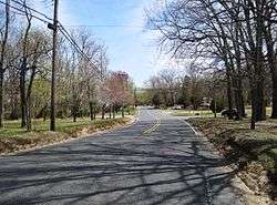
Bairdsville is an unincorporated community on the border of Manalapan and Millstone townships in Monmouth County, New Jersey, United States.[2] The community is centered on the intersection of Woodville Road (County Route 527A) and Baird Road. Near the site of Bairdsville in Millstone is the Thomas Baird Homestead, a home owned by one of the first families to settle in Millstone.[3]
References
- ↑ U.S. Geological Survey Geographic Names Information System: Bairdsville, New Jersey
- ↑ Locality Search, State of New Jersey. Accessed February 14, 2015.
- ↑ Meggitt, Jane (November 22, 2012). "Town becomes owner of Baird Homestead". Examiner. Archived from the original on April 27, 2015. Retrieved April 19, 2015.
This article is issued from Wikipedia - version of the 10/24/2016. The text is available under the Creative Commons Attribution/Share Alike but additional terms may apply for the media files.