Scobeyville, New Jersey
| Scobeyville, New Jersey | |
|---|---|
| Unincorporated community | |
|
Intersection of CR 537 and Laird Road | |
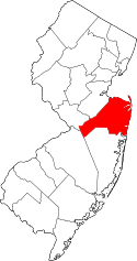
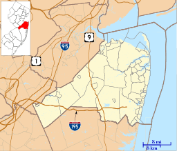 Scobeyville, New Jersey  Scobeyville, New Jersey  Scobeyville, New Jersey Location of Scobeyville in Monmouth County Inset: Location of county within the state of New Jersey | |
| Coordinates: 40°17′49″N 74°08′36″W / 40.29694°N 74.14333°WCoordinates: 40°17′49″N 74°08′36″W / 40.29694°N 74.14333°W | |
| Country |
|
| State |
|
| County | Monmouth |
| Township | Colts Neck |
| Elevation[1] | 72 ft (22 m) |
| Time zone | Eastern (EST) (UTC-5) |
| • Summer (DST) | EDT (UTC-4) |
| ZIP code | 07722 |
| GNIS feature ID | 880423[1] |

Scobeyville is an unincorporated community located within Colts Neck Township in Monmouth County, New Jersey, United States.[2][3] The settlement is named for the Scobey family which has inhabited the township since the 1700s. The site housed a one-room schoolhouse, a post office, and a general store.[4] An apple farm set up by William Laird was located in Scobeyville; the cider produced there were fermented into hard cider and applejack. The distillery operated in Scobeyville form the 1700s to Prohibition and then again since 1933. The Laird family continues to operate an apple distillery in Scobeyville.[5] In addition to the distillery, the remainder of the area today consists of farmland and the Dorbrook Recreational Area. County Route 537 is the main east-west road running through the area while Laird Road heads north from CR 537.[6]
References
- 1 2 "Scobeyville". Geographic Names Information System. United States Geological Survey.
- ↑ Locality Search, State of New Jersey. Accessed March 4, 2015.
- ↑ U.S. Geological Survey (1893). Bulletin of the United States Geological Survey, Volume 22. Retrieved July 15, 2011.
- ↑ "History of Colts Neck". The History of New Jersey Website. Westfield, New Jersey. c. 1965. Retrieved October 4, 2015.
- ↑ "Interesting Facts". Laird & Company. Retrieved October 4, 2015.
- ↑ Google (October 4, 2015). "Aerial view of Scobeyville" (Map). Google Maps. Google. Retrieved October 4, 2015.