Hornerstown, New Jersey
| Hornerstown, New Jersey | |
|---|---|
| Unincorporated community | |
|
Center of Hornerstown | |
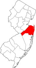
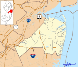 Hornerstown, New Jersey  Hornerstown, New Jersey  Hornerstown, New Jersey Hornerstown's location in Monmouth County (Inset: Location of Monmouth County in New Jersey) | |
| Coordinates: 40°06′22″N 74°30′51″W / 40.10611°N 74.51417°WCoordinates: 40°06′22″N 74°30′51″W / 40.10611°N 74.51417°W | |
| Country |
|
| State |
|
| County | Monmouth |
| Township | Upper Freehold |
| Elevation | 89 ft (27 m) |
| GNIS feature ID | 877255[1] |

Hornerstown is an unincorporated community located within Upper Freehold Township in Monmouth County, New Jersey, United States.[2][3] Hornerstown is located near Cream Ridge and uses the 08514 ZIP code.
Centered about the intersection of Hornerstown-Arneystown Road and Main Street (both separate branches of Monmouth County Route 27), the area is mostly made up of houses with horse farms west of the community. Small businesses line nearby highways CR 537 and CR 539.[4] The town formerly had a stop on the Pemberton and Hightstown Railroad.[5] The former railroad right-of-way has been developed into the Union Transportation Trail.
References
- ↑ "Hornerstown". Geographic Names Information System. United States Geological Survey. Retrieved 2012-09-25.
- ↑ Locality Search, State of New Jersey. Accessed February 24, 2015.
- ↑ U.S. Geological Survey (1893). Bulletin of the United States Geological Survey, Volume 22. Retrieved July 15, 2011.
- ↑ Google (May 24, 2015). "Hornerstown, New Jersey" (Map). Google Maps. Google. Retrieved May 24, 2015.
- ↑ Pennsylvania Railroad and Its Connections (Map). December 1, 1911. Retrieved May 24, 2015.
This article is issued from Wikipedia - version of the 6/8/2016. The text is available under the Creative Commons Attribution/Share Alike but additional terms may apply for the media files.