Marlboro, Monmouth County, New Jersey
| Marlboro, New Jersey | |
|---|---|
| Unincorporated community | |
|
Marlboro as seen from Route 79 | |
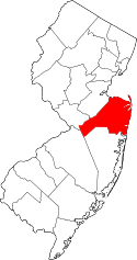
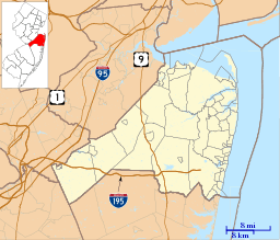 Marlboro, New Jersey  Marlboro, New Jersey  Marlboro, New Jersey Location of Marlboro in Monmouth County Inset: Location of county within the state of New Jersey | |
| Coordinates: 40°18′55″N 74°14′47″W / 40.31528°N 74.24639°WCoordinates: 40°18′55″N 74°14′47″W / 40.31528°N 74.24639°W | |
| Country |
|
| State |
|
| County | Monmouth |
| Township | Marlboro |
| Elevation[1] | 167 ft (51 m) |
| GNIS feature ID | 878130[1] |
%2C_NJ.jpg)
Marlboro is an unincorporated community located within Marlboro Township in Monmouth County, New Jersey, United States.[2]
The settlement is located along Route 79 north of its interchange with Route 18.[3]
Marlboro was likely named for its early use of marl as a fertilizer.[4]
By 1873, Marlboro had a post office, school, hotel, multiple stores, churches, and a railroad station of the Freehold and Keyport Railroad.[5] In 1882, the population was 102.[6]
Marlboro was described in 1939 as having "large frame houses comfortably spaced along the highway".[4]:555
References
- 1 2 "Marlboro". Geographic Names Information System. United States Geological Survey.
- ↑ Locality Search, State of New Jersey. Accessed February 26, 2015.
- ↑ Google (December 15, 2015). "Aerial view of Marlboro" (Map). Google Maps. Google. Retrieved December 15, 2015.
- 1 2 New Jersey, a Guide to Its Present and Past. Viking. 1939. p. 555.
- ↑ F.W. Beers, Monmouth County, 1873, p. 29
- ↑ Industries of New Jersey. Historical Publishing Company. 1882. p. 101.
This article is issued from Wikipedia - version of the 6/9/2016. The text is available under the Creative Commons Attribution/Share Alike but additional terms may apply for the media files.