Navesink, New Jersey
| Navesink, New Jersey | |
|---|---|
| Census-designated place | |
|
Center of Navesink | |
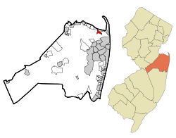 Map of Navesink in Monmouth County. Inset: Location of Monmouth County in New Jersey. | |
| Coordinates: 40°24′04″N 74°02′26″W / 40.401105°N 74.040464°WCoordinates: 40°24′04″N 74°02′26″W / 40.401105°N 74.040464°W | |
| Country |
|
| State |
|
| County | Monmouth |
| Township | Middletown |
| Area[1] | |
| • Total | 0.896 sq mi (2.321 km2) |
| • Land | 0.885 sq mi (2.291 km2) |
| • Water | 0.011 sq mi (0.030 km2) 1.27% |
| Elevation[2] | 118 ft (36 m) |
| Population (2010)[3] | |
| • Total | 2,020 |
| • Density | 2,283.6/sq mi (881.7/km2) |
| Time zone | Eastern (EST) (UTC-5) |
| • Summer (DST) | Eastern (EDT) (UTC-4) |
| ZIP code | 07752[4] |
| Area code(s) | 732/848 |
| FIPS code | 3449740[1][5] |
| GNIS feature ID | 02389532[1][6] |

Navesink is an unincorporated community and census-designated place (CDP) within Middletown Township, in Monmouth County, New Jersey, United States.[7][8][9] As of the 2010 United States Census, the CDP's population was 2,020.[3]
Geography

According to the United States Census Bureau, Navesink had a total area of 0.896 square miles (2.321 km2), including 0.885 square miles (2.291 km2) of land and 0.011 square miles (0.030 km2) of water (1.27%).[1][10]
Demographics
| Historical population | |||
|---|---|---|---|
| Census | Pop. | %± | |
| 2000 | 1,962 | — | |
| 2010 | 2,020 | 3.0% | |
| Population sources: 2000-2010[7] 2000[11] 2010[3] | |||
Census 2010
The 2010 United States Census counted 2,020 people, 691 households, and 549.3 families residing in the CDP. The population density was 2,283.6 per square mile (881.7/km2). The CDP contained 732 housing units at an average density of 827.5 per square mile (319.5/km2). The racial makeup of the CDP was 89.55% (1,809) White, 6.09% (123) Black or African American, 0.10% (2) Native American, 2.23% (45) Asian, 0.00% (0) Pacific Islander, 0.74% (15) from other races, and 1.29% (26) from two or more races. Hispanics or Latinos of any race were 4.95% (100) of the population.[3]
Out of a total of 691 households, 38.5% had children under the age of 18 living with them, 63.5% were married couples living together, 11.6% had a female householder with no husband present, and 20.5% were non-families. 16.6% of all households were made up of individuals, and 4.6% had someone living alone who was 65 years of age or older. The average household size was 2.92 and the average family size was 3.30.[3]
In the CDP, 27.1% of the population were under the age of 18, 6.6% from 18 to 24, 23.1% from 25 to 44, 33.7% from 45 to 64, and 9.4% who were 65 years of age or older. The median age was 40.7 years. For every 100 females the census counted 90.6 males, but for 100 females at least 18 years old, it was 90.2 males.[3]
Census 2000
As of the 2000 United States Census[5] there were 1,962 people, 623 households, and 497 families residing in the CDP. The population density was 2,178.8 people per square mile (841.7/km2). There were 647 housing units at an average density of 718.5/sq mi (277.6/km2). The racial makeup of the CDP was 84.20% White, 12.03% African American, 0.25% Native American, 1.38% Asian, 0.05% Pacific Islander, 0.56% from other races, and 1.53% from two or more races. Hispanic or Latino of any race were 2.55% of the population.[11]
There were 623 households out of which 39.5% had children under the age of 18 living with them, 64.4% were married couples living together, 12.0% had a female householder with no husband present, and 20.1% were non-families. 14.8% of all households were made up of individuals and 5.1% had someone living alone who was 65 years of age or older. The average household size was 2.93 and the average family size was 3.26.[11]
In the CDP the population was spread out with 26.2% under the age of 18, 4.9% from 18 to 24, 29.2% from 25 to 44, 25.2% from 45 to 64, and 14.5% who were 65 years of age or older. The median age was 40 years. For every 100 females there were 94.4 males. For every 100 females age 18 and over, there were 87.6 males.[11]
The median income for a household in the CDP was $81,456, and the median income for a family was $86,865. Males had a median income of $56,786 versus $40,833 for females. The per capita income for the CDP was $27,673. None of the families and 1.6% of the population were living below the poverty line, including no under eighteens and 8.5% of those over 64.[11]
Local attractions
In 1841, Navesink became the site of the first lighthouse in the United States to be equipped with a Fresnel lens.[12]
Transportation
New Jersey Transit offers local bus service on the 834 route.[13] Major roads in the CDP include New Jersey Route 36 and County Route 516, both of which clip the northern end of the CDP's limits.
Notable people
People who were born in, residents of, or otherwise closely associated with Navesink include:
- Richard Scudder (1913-2012), newspaper pioneer and co-founder of the MediaNews Group.[14]
References
- 1 2 3 4 Gazetteer of New Jersey Places, United States Census Bureau. Accessed July 21, 2016.
- ↑ U.S. Geological Survey Geographic Names Information System: Navesink Census Designated Place, Geographic Names Information System. Accessed August 8, 2012.
- 1 2 3 4 5 6 DP-1 - Profile of General Population and Housing Characteristics: 2010 Demographic Profile Data for Navesink CDP, New Jersey, United States Census Bureau. Accessed August 8, 2012.
- ↑ Look Up a ZIP Code for Navesink, NJ, United States Postal Service. Accessed August 7, 2012.
- 1 2 American FactFinder, United States Census Bureau. Accessed September 4, 2014.
- ↑ US Board on Geographic Names, United States Geological Survey. Accessed September 4, 2014.
- 1 2 New Jersey: 2010 - Population and Housing Unit Counts - 2010 Census of Population and Housing (CPH-2-32), United States Census Bureau, August 2012. Accessed December 16, 2012.
- ↑ GCT-PH1 - Population, Housing Units, Area, and Density: 2010 - County -- County Subdivision and Place from the 2010 Census Summary File 1 for Monmouth County, New Jersey, United States Census Bureau. Accessed December 16, 2012.
- ↑ Locality Search, State of New Jersey. Accessed April 19, 2015.
- ↑ US Gazetteer files: 2010, 2000, and 1990, United States Census Bureau. Accessed September 4, 2014.
- 1 2 3 4 5 DP-1 - Profile of General Demographic Characteristics: 2000 from the Census 2000 Summary File 1 (SF 1) 100-Percent Data for Navseink CDP, New Jersey, United States Census Bureau. Accessed August 8, 2012.
- ↑ Navesink Twin Lights - Highlands, NJ, New Jersey Lighthouse Society. Accessed July 21, 2016. "Despite their condition, in 1841, the towers became the first lighthouses in the United States to be equipped with Fresnel lens."
- ↑ Monmouth County Bus / Rail Connections, New Jersey Transit, backed up by the Internet Archive as of July 26, 2010. Accessed August 8, 2012.
- ↑ Hevesi, Dennis. "Richard B. Scudder, Co-Founder of MediaNews Group, Dies at 99", The New York Times, July 15, 2012. Accessed August 12, 2012. "Richard B. Scudder, a founder and former chairman of MediaNews Group, one of the nation's largest newspaper chains, and an innovator in recycling newsprint, died on July 11 at his home in Navesink, N.J. He was 99."