Balâ, Ankara
| Bala | |
|---|---|
| District | |
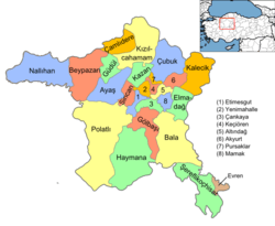 Location of Bala, Ankara within Turkey. | |
 Bala Location of Bala, Ankara within Turkey. | |
| Coordinates: 39°33′N 33°07′E / 39.550°N 33.117°E | |
| Country |
|
| Region | Central Anatolia |
| Province | Ankara Province |
| Government | |
| • Governor | Kamuran Mustafa Ballı |
| • Mayor | İbrahim Gürbüz (MHP) |
| Area[1] | |
| • District | 2,562.94 km2 (989.56 sq mi) |
| Elevation | 1,310 m (4,300 ft) |
| Population (2012)[2] | |
| • Urban | 7,542 |
| • District | 17,397 |
| • District density | 6.8/km2 (18/sq mi) |
| Time zone | EET (UTC+2) |
| • Summer (DST) | EEST (UTC+3) |
| Postal code | 06xxx |
| Area code(s) | 0312 |
| Licence plate | 06 |
| Website | www.bala.gov.tr |
Bala is a town and district of Ankara Province in the Central Anatolia region of Turkey, 67 km south-east of the city of Ankara. According to 2000 census, population of the district is 19,426 of which 8,506 live in the urban center of Bala.[3][4] The district covers an area of 2,563 km2 (990 sq mi),[5] and the average elevation is 1,310 m (4,298 ft).
Bala stands on a high plain, summers are hot, winters are cold and snowy. The town of Bala is small but busy with shops and light manufacturing workshops, the surrounding countryside is used for farming, especially grains and sunflower seeds. Recently Ankara's wealthier citizens have begun building luxury housing in some villages of Bala. However the town stands on a fault line and experiences many earthquakes.
Places of interest
The forest of Beynam and the Kesikköprü reservoir are two of Ankara's most popular picnic spots.
Settlements in the district
Towns
- Afşar
- Bala
Villages
- Abazlı
- Ahmetçayırı
- Akarlar
- Akörençarşak
- Aydoğan
- Aşağıhacıbekir
- Aşıkoğlu
- Bahçekaradalak
- Bağiçi
- Bektaşlı
- Belçarsak
- Beynam
- Buyukdavdanlı
- Büyükboyalık
- Büyükbıyık
- Büyükcamili
- Davdanlı
- Derekışla
- Erdemli
- Ergin
- Evciler
- Eğribasan
- Gülbağı
- Hanburun
- Karahamzalı
- Keklicek
- Kerişli
- Kesikköprü
- Koçyayla
- Kömürcü
- Köseli
- Küçükbayat
- Küçükboyalık
- Küçükbıyık
- Küçükcamili
- Sarıhüyük
- Sehrıban
- Sofular
- Suyugüzel
- Sırapınar
- Tatarhüyük
- Tepeköy
- Tolköy
- Yaylaköy
- Yaylalıözü
- Yeniköy
- Yeniyapançarşak
- Yeniyapanşeyhli
- Yukarıhacıbekir
- Yöreli
- Çatalçeşme
- Çatalören
- Çiğdemli
- Üçem
- Şehriban
Notes
- ↑ "Area of regions (including lakes), km²". Regional Statistics Database. Turkish Statistical Institute. 2002. Retrieved 2013-03-05.
- ↑ "Population of province/district centers and towns/villages by districts - 2012". Address Based Population Registration System (ABPRS) Database. Turkish Statistical Institute. Retrieved 2013-02-27.
- ↑ "Population of city, towns and villages - 2010".
- ↑ GeoHive. "Statistical information on Turkey's administrative units". Retrieved 2008-03-28.
- ↑ Statoids. "Statistical information on districts of Turkey". Retrieved 2008-04-23.
References
- Falling Rain Genomics, Inc. "Geographical information on Bala, Turkey". Retrieved 2008-03-28.
- Kenthaber.com. "General information on Bala district of Ankara" (in Turkish). Retrieved 2008-03-28.
External links
- District governor's official website (Turkish)
- District municipality's official website (Turkish)
Coordinates: 39°33′14″N 33°07′16″E / 39.55389°N 33.12111°E