Baulou
| Baulou | |
|---|---|
|
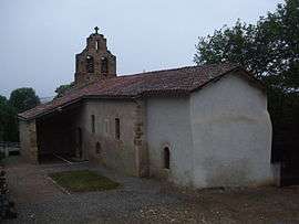
The church in Baulou | |
 Baulou | |
|
Location within Occitanie region  Baulou | |
| Coordinates: 43°01′01″N 1°32′03″E / 43.0169°N 1.5342°ECoordinates: 43°01′01″N 1°32′03″E / 43.0169°N 1.5342°E | |
| Country | France |
| Region | Occitanie |
| Department | Ariège |
| Arrondissement | Foix |
| Canton | Foix-Rural |
| Intercommunality | Pays de Foix |
| Government | |
| • Mayor (2014–2020) | Nathalie Esquinol |
| Area1 | 14.62 km2 (5.64 sq mi) |
| Population (2010)2 | 160 |
| • Density | 11/km2 (28/sq mi) |
| Time zone | CET (UTC+1) |
| • Summer (DST) | CEST (UTC+2) |
| INSEE/Postal code | 09044 / 09000 |
| Elevation |
393–655 m (1,289–2,149 ft) (avg. 490 m or 1,610 ft) |
|
1 French Land Register data, which excludes lakes, ponds, glaciers > 1 km² (0.386 sq mi or 247 acres) and river estuaries. 2 Population without double counting: residents of multiple communes (e.g., students and military personnel) only counted once. | |
Baulou is a French commune in the Ariège department in the Occitanie region of south-western France.[1]
The inhabitants of the commune are known as Baulouais or Baulouaises.[2]
Geography
Baulou is located in the Pre-Pyrenees in the Plauntaurel Mountains and a part of the Parc naturel régional des Pyrénées ariégeoises some 12 km south by south-west of Pamiers and 6 km north-west of Foix. Access to the commune is by the D1 road from Vernajoul in the south-east which passes through the commune and ends in the village. The D11 branches from the D117 south-west of the commune and passes through continuing north-east to Loubens. The D1a branches off the D11 in the commune and goes north-west to Aigues-Juntes. Apart from the village there is the hamlet of Clarac in the commune. The commune is mainly forest with some farmland along the D1 and in scattered parts.[3][4]
The Ruisseau d'Argentat rises north of the village and flows towards the north-west into a small artificial lake before continuing north-west to join the Lèze north-west of Aigues-Juntes. Many streams feed the left bank of the Ruisseau d'Argentat including the Goute de Chenaut which also forms the north-western border of the commune, the Freyché, the Goute de Tariol, the Goute du Peyfourcat, and the Goute du Gouas. The Ruisseau de Carol flows from the south to the village then continues north to join the Ruisseau de la Plaine north of the commune. The Fajal rises in the north-east of the commune and flows south.[3][4]
Mapping
A list of online mapping systems can be displayed by clicking on the coordinates (latitude and longitude) in the top right hand corner of this article.
Neighbouring communes and villages
 |
Aigues-Juntes | Loubens | Crampagna | |
| La Bastide-de-Sérou | |
Loubières | ||
| ||||
| | ||||
| Cadarcet | Saint-Martin-de-Caralp | Vernajoul |
Toponymy
Baulou appears as Boulou on the 1750 Cassini Map[5] and the same on the 1790 version.[6]
History
In 1901, during the building of the Foix - Saint Girons railway a mammoth was discovered called and called the "Mammoth of Baulou" by the scientific community.[7] It was displayed in the hall of the Château de Foix departmental museum[8] before being transferred to the Parc pyrénéen de l'art préhistorique (Pyrenean park of prehistoric art) at Tarascon-sur-Ariège.[9]
Administration
| From | To | Name | Party | Position |
|---|---|---|---|---|
| 2001 | 2014 | Robert Baures | ||
| 2014 | 2020 | Nathalie Esquinol |
(Not all data is known)
Demography
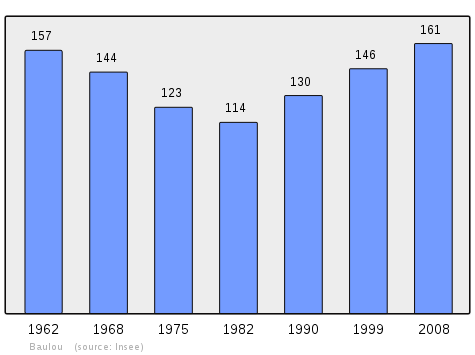
In 2010 the commune had 160 inhabitants. The evolution of the number of inhabitants is known from the population censuses conducted in the commune since 1793. From the 21st century, a census of communes with fewer than 10,000 inhabitants is held every five years, unlike larger communes that have a sample survey every year.[Note 1]
| 1793 | 1800 | 1806 | 1821 | 1831 | 1836 | 1841 | 1846 | 1851 |
|---|---|---|---|---|---|---|---|---|
| 350 | 199 | 424 | 360 | 447 | 458 | 470 | 491 | 481 |
| 1856 | 1861 | 1866 | 1872 | 1876 | 1881 | 1886 | 1891 | 1896 |
|---|---|---|---|---|---|---|---|---|
| 464 | 478 | 465 | 482 | 523 | 477 | 452 | 402 | 589 |
| 1901 | 1906 | 1911 | 1921 | 1926 | 1931 | 1936 | 1946 | 1954 |
|---|---|---|---|---|---|---|---|---|
| 458 | 371 | 349 | 236 | 246 | 237 | 224 | 216 | 210 |
| 1962 | 1968 | 1975 | 1982 | 1990 | 1999 | 2006 | 2010 | - |
|---|---|---|---|---|---|---|---|---|
| 157 | 144 | 123 | 114 | 130 | 146 | 163 | 160 | - |
Sources : Ldh/EHESS/Cassini until 1962, INSEE database from 1968 (population without double counting and municipal population from 2006)

Sites and monuments

- The Labouiche Subterranean River
See also
Notes and references
Notes
- ↑ At the beginning of the 21st century, the methods of identification have been modified by Law No. 2002-276 of 27 February 2002, the so-called "law of local democracy" and in particular Title V "census operations" allows, after a transitional period running from 2004 to 2008, the annual publication of the legal population of the different French administrative districts. For communes with a population greater than 10,000 inhabitants, a sample survey is conducted annually and the entire territory of these communes is taken into account at the end of the period of five years. The first "legal population" after 1999 under this new law came into force on 1 January 2009 and was based on the census of 2006.
References
- ↑ Baulou on Lion1906
- ↑ Inhabitants of Ariège (French)
- 1 2 3 Baulou on Google Maps
- 1 2 Baulou on the Géoportail from National Geographic Institute (IGN) website (French)
- ↑ Boulou on the 1750 Cassini Map
- ↑ Boulou on the 1790 Cassini Map
- ↑ L. Bertrand, Discovery of a Mammoth Skeleton at Baulou, near Foix (Ariège), Bulletin of the Geological Society of France, 1901, Vol. 1, 187 pages, (French)
- ↑ The Mammouth of Baulou restored from its ashes, Stéphane Marcelot, 20 May 2009 (French)
- ↑ Saint-Girons. To discover or rediscover, 17 May 2013, consulted on 21 December 2014 (French)
- ↑ List of Mayors of France (French)
| Wikimedia Commons has media related to Baulou. |