Aulos, Ariège
| Aulos | |
|---|---|
|
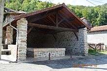
The entry to Aulos | |
 Aulos | |
|
Location within Occitanie region  Aulos | |
| Coordinates: 42°47′36″N 1°40′33″E / 42.7933°N 1.6758°ECoordinates: 42°47′36″N 1°40′33″E / 42.7933°N 1.6758°E | |
| Country | France |
| Region | Occitanie |
| Department | Ariège |
| Arrondissement | Foix |
| Canton | Cabannes |
| Intercommunality | Vallées d'Ax |
| Government | |
| • Mayor (2008–2020) | Jean-Yves Cencigh |
| Area1 | 1.04 km2 (0.40 sq mi) |
| Population (2010)2 | 55 |
| • Density | 53/km2 (140/sq mi) |
| Time zone | CET (UTC+1) |
| • Summer (DST) | CEST (UTC+2) |
| INSEE/Postal code | 09028 / 09310 |
| Elevation |
513–968 m (1,683–3,176 ft) (avg. 612 m or 2,008 ft) |
|
1 French Land Register data, which excludes lakes, ponds, glaciers > 1 km² (0.386 sq mi or 247 acres) and river estuaries. 2 Population without double counting: residents of multiple communes (e.g., students and military personnel) only counted once. | |

Aulos is a French commune in the Ariège department in the Occitanie region of south-western France.
The inhabitants of the commune are known as Aulosois or Aulosoises.[1]
Geography
Aulos is located some 12 km south-east of Tarascon-sur-Ariège and 22 km north-west of Ax-les-Thermes. Access to the commune is by Route nationale 20 from Sinsat in the north-west passing through the north of the commune and continuing south-east to Luzenac. Access to the village is by the D522 road which branches off the N20 in the commune and goes south-east through the village continuing to Les Cabannes. A railway line passes through the commune with the nearest station at Les Cabannes. Most of the commune is heavily forested with a strip of farmland along the N20 and the D522.[2]
The Ariège river forms the whole eastern border of the commune with no tributaries passing through the commune.[2]
Neighbouring communes and villages[2]
 |
Sinsat | | ||
| Larnat | |
Verdun | ||
| ||||
| | ||||
| Larcat | Château-Verdun | Les Cabannes |
Administration
List of Successive Mayors[3]
| From | To | Name | Party | Position |
|---|---|---|---|---|
| 2001 | 2020 | Jean-Yves Cencigh |
(Not all data is known)
Demography
In 2010 the commune had 55 inhabitants. The evolution of the number of inhabitants is known from the population censuses conducted in the commune since 1793. From the 21st century, a census of communes with fewer than 10,000 inhabitants is held every five years, unlike larger towns that have a sample survey every year.[Note 1]
| 1793 | 1800 | 1806 | 1821 | 1831 | 1836 | 1841 | 1846 | 1851 |
|---|---|---|---|---|---|---|---|---|
| - | 77 | 113 | 101 | 100 | 113 | 118 | 122 | 127 |
| 1856 | 1861 | 1866 | 1872 | 1876 | 1881 | 1886 | 1891 | 1896 |
|---|---|---|---|---|---|---|---|---|
| 119 | 110 | 104 | 95 | 92 | 88 | 98 | 111 | 104 |
| 1901 | 1906 | 1911 | 1921 | 1926 | 1931 | 1936 | 1946 | 1954 |
|---|---|---|---|---|---|---|---|---|
| 105 | 102 | 91 | 89 | 79 | 65 | 76 | 73 | 80 |
| 1962 | 1968 | 1975 | 1982 | 1990 | 1999 | 2006 | 2010 | - |
|---|---|---|---|---|---|---|---|---|
| 71 | 91 | 81 | 60 | 38 | 60 | 58 | 55 | - |
Sources : Ldh/EHESS/Cassini until 1962, INSEE database from 1968 (population without double counting and municipal population from 2006)


See also
External links
- Aulos on the old IGN website (French)
- Aulos on Lion1906
- Aulos on Google Maps
- Aulos on Géoportail, National Geographic Institute (IGN) website (French)
- Aulos on the 1750 Cassini Map
- Aulos on the INSEE website (French)
- INSEE (French)
Notes and references
Notes
- ↑ At the beginning of the 21st century, the methods of identification have been modified by Law No. 2002-276 of 27 February 2002, the so-called "law of local democracy" and in particular Title V "census operations" allows, after a transitional period running from 2004 to 2008, the annual publication of the legal population of the different French administrative districts. For communes with a population greater than 10,000 inhabitants, a sample survey is conducted annually, the entire territory of these communes is taken into account at the end of the period of five years. The first "legal population" after 1999 under this new law came into force on 1 January 2009 and was based on the census of 2006.
References
- ↑ Inhabitants of Ariège (French)
- 1 2 3 Google Maps
- ↑ List of Mayors of France (French)
| Wikimedia Commons has media related to Aulos (Ariège). |