Galey
| Galey | |
|---|---|
|
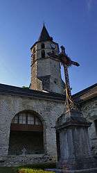
The church in Galey | |
 Galey | |
|
Location within Occitanie region  Galey | |
| Coordinates: 42°56′13″N 0°54′59″E / 42.9369°N 0.9164°ECoordinates: 42°56′13″N 0°54′59″E / 42.9369°N 0.9164°E | |
| Country | France |
| Region | Occitanie |
| Department | Ariège |
| Arrondissement | Saint-Girons |
| Canton | Saint-Lizier |
| Intercommunality | Bas-Couserans |
| Government | |
| • Mayor (2014–2020) | Patricia Dandurand |
| Area1 | 8.17 km2 (3.15 sq mi) |
| Population (2008)2 | 113 |
| • Density | 14/km2 (36/sq mi) |
| Time zone | CET (UTC+1) |
| • Summer (DST) | CEST (UTC+2) |
| INSEE/Postal code | 09128 / 09800 |
| Elevation |
365–600 m (1,198–1,969 ft) (avg. 550 m or 1,800 ft) |
|
1 French Land Register data, which excludes lakes, ponds, glaciers > 1 km² (0.386 sq mi or 247 acres) and river estuaries. 2 Population without double counting: residents of multiple communes (e.g., students and military personnel) only counted once. | |
Galey is a commune in the Ariège department in southwestern France.
Population
| Historical population | ||
|---|---|---|
| Year | Pop. | ±% |
| 1962 | 97 | — |
| 1968 | 131 | +35.1% |
| 1975 | 121 | −7.6% |
| 1982 | 114 | −5.8% |
| 1990 | 82 | −28.1% |
| 1999 | 101 | +23.2% |
| 2008 | 113 | +11.9% |
See also
References
| Wikimedia Commons has media related to Galey. |
This article is issued from Wikipedia - version of the 3/15/2016. The text is available under the Creative Commons Attribution/Share Alike but additional terms may apply for the media files.