Albiès
| Albiès | |
|---|---|
|
Albiès railway bridge | |
 Albiès | |
|
Location within Occitanie region  Albiès | |
| Coordinates: 42°46′42″N 1°42′10″E / 42.7783°N 1.7028°ECoordinates: 42°46′42″N 1°42′10″E / 42.7783°N 1.7028°E | |
| Country | France |
| Region | Occitanie |
| Department | Ariège |
| Arrondissement | Foix |
| Canton | Cabannes |
| Intercommunality | Vallées d'Ax |
| Government | |
| • Mayor (2008–2020) | Jean-Claude Prat |
| Area1 | 7.69 km2 (2.97 sq mi) |
| Population (2009)2 | 137 |
| • Density | 18/km2 (46/sq mi) |
| Time zone | CET (UTC+1) |
| • Summer (DST) | CEST (UTC+2) |
| INSEE/Postal code | 09004 / 09310 |
| Elevation |
531–1,887 m (1,742–6,191 ft) (avg. 560 m or 1,840 ft) |
|
1 French Land Register data, which excludes lakes, ponds, glaciers > 1 km² (0.386 sq mi or 247 acres) and river estuaries. 2 Population without double counting: residents of multiple communes (e.g., students and military personnel) only counted once. | |

Albiès is a French commune in the Ariège department in the Occitanie region of southwestern France.
The inhabitants of the commune are known as Albiésois or Albiésoises[1]
Geography
Albiès is a long narrow commune oriented north-south about 25 km south by south-east of Foix and 15 km west by north-west of Ax-les-Thermes. It is traversed by Route Nationale N20 (E9) from Verdun in the north-west passing south of the village and continuing to the east. It is also possible to access the southern tip of the commune by road D522 from Les Cabannes to the west of the village via a tortuous mountain route west of the commune arriving at the southern tip of the commune where it terminates. The commune south of the N20 highway is heavily forested and inaccessible mountainous terrain. The village can be accessed by the Rue de Nappy going north from the N20 highway. A railway line passes through the village from west to east but there is no station in the commune. The nearest station is at Les Cabannes some 4 km to the west.[2]

The Ariège river passes through the village flowing east parallel to the N20. The Ruisseau de Caychax flows from the north of the commune into the Ariège. The Ruisseau de Sauzelles rises in the south of the commune and flows north joining the Ruisseau de l'Oule which rises in the south-west and forms the southern portion of the western border before joining the Ruisseau de Sauzelles and becoming the Ruisseau de Lavel d'Albiès which is most of the western border before joining the Ravin de la Rescalbade and flowing into the Ariège as the Ruisseau de la Garganle. A separate stream - the Ruisseau de Garganle - forms part of the eastern border where it flows into the Ariège.[2]
Neighbouring communes and villages[2]
 |
Verdun | | ||
| Les Cabannes | |
Vebre | ||
| ||||
| | ||||
| Aston |
Administration
List of Successive Mayors[3]
| From | To | Name | Party | Position |
|---|---|---|---|---|
| 2001 | 2020 | Jean-Claude Prat | SE |
(Not all data is known)
Demography
In 2009, the commune had 137 inhabitants. The evolution of the number of inhabitants is known through the population censuses conducted in the commune since 1793. From the 21st century, a census of communes with fewer than 10,000 inhabitants is held every five years, unlike larger towns that have a sample survey every year.[Note 1]
| 1793 | 1800 | 1806 | 1821 | 1831 | 1836 | 1841 | 1846 | 1851 |
|---|---|---|---|---|---|---|---|---|
| - | 359 | 436 | 433 | 475 | 463 | 461 | 462 | 450 |
| 1856 | 1861 | 1866 | 1872 | 1876 | 1881 | 1886 | 1891 | 1896 |
|---|---|---|---|---|---|---|---|---|
| 428 | 430 | 382 | 331 | 401 | 404 | 406 | 405 | 403 |
| 1901 | 1906 | 1911 | 1921 | 1926 | 1931 | 1936 | 1946 | 1954 |
|---|---|---|---|---|---|---|---|---|
| 351 | 334 | 306 | 253 | 245 | 247 | 203 | 191 | 183 |
| 1962 | 1968 | 1975 | 1982 | 1990 | 1999 | 2006 | 2009 | - |
|---|---|---|---|---|---|---|---|---|
| 170 | 146 | 163 | 144 | 141 | 151 | 139 | 137 | - |
Sources : Ldh/EHESS/Cassini until 1962, INSEE database from 1968 (population without double counting and municipal population from 2006)


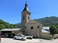

Religious heritage
The Parish Church contains a Collection plate (17th century)![]() which is registered as an historical object.[4]
which is registered as an historical object.[4]
Notable people linked to the commune
- Monseigneur Jean-Marie Vidal (1872-1940), Bishop of Pamiers, historian and writer.
- Jacques Martiel (born 13 December 1946), journalist, publisher and Printer.
See also
- Communes of the Ariège department
- Cantons of the Ariège department
- Arrondissements of the Ariège department
External links
- Albiès on the old IGN website (French)
- Albiès on Lion1906
- Albiès on Google Maps
- Albiès on Géoportail, National Geographic Institute (IGN) website (French)
- Albies on the 1750 Cassini Map
- Albiès on the INSEE website (French)
- INSEE (French)
Notes and references
Notes
- ↑ At the beginning of the 21st century, the methods of identification have been modified by law No. 2002-276 of 27 February 2002 , the so-called "law of local democracy" and in particular Title V "census operations" which allow, after a transitional period running from 2004 to 2008, the annual publication of the legal population of the different French administrative districts. For municipalities with a population greater than 10,000 inhabitants, a sample survey is conducted annually, the entire territory of these municipalities is taken into account at the end of the period of five years. The first "legal population" after 1999 under this new law came into force on 1 January 2009 and was based on the census of 2006.
References
- ↑ Inhabitants of Ariège (French)
- 1 2 3 Google Maps
- ↑ List of Mayors of Albiès
- ↑ Ministry of Culture, Palissy PM09000002 Collection plate
(French)

| Wikimedia Commons has media related to Albiès. |