La Bastide-de-Bousignac
| La Bastide-de-Bousignac | |
|---|---|
|
The bell tower in La Bastide-de-Bousignac | |
 La Bastide-de-Bousignac | |
|
Location within Occitanie region  La Bastide-de-Bousignac | |
| Coordinates: 43°03′17″N 1°53′10″E / 43.0547°N 1.8861°ECoordinates: 43°03′17″N 1°53′10″E / 43.0547°N 1.8861°E | |
| Country | France |
| Region | Occitanie |
| Department | Ariège |
| Arrondissement | Pamiers |
| Canton | Mirepoix |
| Intercommunality | Pays de Mirepoix |
| Government | |
| • Mayor (2014–2020) | Grégory Balard |
| Area1 | 12.53 km2 (4.84 sq mi) |
| Population (2010)2 | 339 |
| • Density | 27/km2 (70/sq mi) |
| Time zone | CET (UTC+1) |
| • Summer (DST) | CEST (UTC+2) |
| INSEE/Postal code | 09039 / 09500 |
| Elevation |
310–500 m (1,020–1,640 ft) (avg. 326 m or 1,070 ft) |
|
1 French Land Register data, which excludes lakes, ponds, glaciers > 1 km² (0.386 sq mi or 247 acres) and river estuaries. 2 Population without double counting: residents of multiple communes (e.g., students and military personnel) only counted once. | |

La Bastide-de-Bousignac is a French commune in the Ariège department in the Occitanie region of south-western France.[1]
The inhabitants of the commune are known as Bousignacois or Bousignacoises.[2]
Geography
La Bastide-de-Bousignac is located just 3 km south of Mirepoix and 2 km north of Saint-Quentin-la-Tour. Access to the commune is by the D625 road from Mirepoix which passes through the centre of the commune and the village and continues south to Saint-Quentin-la-Tour. The D7 goes east from the village to Lagarde. The D7A goes south-west from the village to Saint-Julien-de-Gras-Capou. The D78 comes from Saint-Julien-de-Gras-Capou in the south and passes north through the western arm of the commune continuing to join the D13 south of Besset. The commune is mixed farmland and forest.[3][4]
The Countirou river flows from the south through the centre of the commune and the village and continues north to join the Hers at Mirepoix. The Ruisseau de Gradal rises in the east of the commune and flows west to join the Countirou north of the village. The Ruisseau de Mazeroles flows through the western arm of the commune from south to north continuing north to join the Hers at Besset.[3][4]
Mapping
A list of online mapping systems can be displayed by clicking on the coordinates (latitude and longitude) in the top right hand corner of this article.
Neighbouring communes and villages
 |
Besset | Mirepoix | Roumengoux | |
| Viviès | |
Lagarde | ||
| ||||
| | ||||
| Troye-d'Ariège | Saint-Quentin-la-Tour |
History
La Bastide-de-Bousignac appears as la Baftide de Bouzujnac on the 1750 Cassini Map[5] and as la Baftide on the 1790 version.[6]
Administration
| From | To | Name | Party | Position |
|---|---|---|---|---|
| 1790 | 1792 | Jean Lanta | ||
| 1792 | 1794 | Jean Boudouresque | ||
| 1794 | 1798 | Jean Pilles | ||
| 1798 | 1815 | Joseph Boudouresque | ||
| 1815 | 1824 | Baptiste Fidency | ||
| 1824 | 1830 | Maurice Boudouresque | ||
| 1830 | 1847 | François Authie | ||
| 1847 | 1865 | François Boudouresque | ||
| 1865 | 1870 | Jean Baptiste Authie | ||
| 1870 | 1871 | François Boudouresque | ||
| 1871 | 1877 | Jean Baptiste Authie | ||
| 1877 | 1909 | Maurice Boudouresque | ||
| 1909 | 1920 | Noël Authie | ||
| 1920 | 1929 | Jules Senié | ||
| 1929 | 1947 | Joseph Henri Elie Cassagne | ||
| 1947 | 2014 | Roger Senié | ||
| 2014 | 2020 | Grégory Balard |
(Not all data is known)
In February 2013 Roger Senie announces he would not stand in 2014.[8][9] In July 2013 he was reelected mayor after resigning in protest against the forced inclusion of La Bastide-de-Bousignac into the community of communes of the Pays de Mirepoix. Serving from 1947 to 2014, he was the oldest mayor in France equally with Arthur Richier, the mayor of Faucon-du-Caire in Alpes-de-Haute-Provence.[10] who, like him, did not stand in March 2014.[11]
Demography
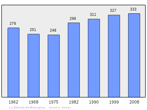
In 2010 the commune had 339 inhabitants. The evolution of the number of inhabitants is known from the population censuses conducted in the commune since 1793. From the 21st century, a census of communes with fewer than 10,000 inhabitants is held every five years, unlike larger communes that have a sample survey every year.[Note 1]
| 1793 | 1800 | 1806 | 1821 | 1831 | 1836 | 1841 | 1846 | 1851 |
|---|---|---|---|---|---|---|---|---|
| 454 | 378 | 457 | 460 | 504 | 505 | 489 | 516 | 507 |
| 1856 | 1861 | 1866 | 1872 | 1876 | 1881 | 1886 | 1891 | 1896 |
|---|---|---|---|---|---|---|---|---|
| 477 | 484 | 458 | 449 | 439 | 443 | 427 | 403 | 390 |
| 1901 | 1906 | 1911 | 1921 | 1926 | 1931 | 1936 | 1946 | 1954 |
|---|---|---|---|---|---|---|---|---|
| 355 | 343 | 323 | 272 | 280 | 290 | 272 | 267 | 284 |
| 1962 | 1968 | 1975 | 1982 | 1990 | 1999 | 2006 | 2010 | - |
|---|---|---|---|---|---|---|---|---|
| 276 | 251 | 248 | 296 | 311 | 327 | 339 | - |
Sources : Ldh/EHESS/Cassini until 1962, INSEE database from 1968 (population without double counting and municipal population from 2006)
Culture and heritage

Religious heritage
- The Church Bell (Middle Ages)
 is registered as an historical monument.[12]
Notable people linked to the commune
- Pierre Espert de Sibra (1771-1835), General of the armies of the Republic and the Empire, died in the hamlet of Balach.
- Roger Sénié (born in 1921), Mayor of the commune from 1947 to 2014
See also
Notes and references
Notes
- ↑ At the beginning of the 21st century, the methods of identification have been modified by Law No. 2002-276 of 27 February 2002, the so-called "law of local democracy" and in particular Title V "census operations" allows, after a transitional period running from 2004 to 2008, the annual publication of the legal population of the different French administrative districts. For communes with a population greater than 10,000 inhabitants, a sample survey is conducted annually and the entire territory of these communes is taken into account at the end of the period of five years. The first "legal population" after 1999 under this new law came into force on 1 January 2009 and was based on the census of 2006.
References
- ↑ La Bastide-de-Bousignac on Lion1906
- ↑ Inhabitants of Ariège (French)
- 1 2 3 La Bastide-de-Bousignac on Google Maps
- 1 2 La Bastide-de-Bousignac on the Géoportail from National Geographic Institute (IGN) website (French)
- ↑ la Baftide de Bouzujnac on the 1750 Cassini Map
- ↑ la Baftide on the 1790 Cassini Map
- ↑ List of Mayors of France (French)
- ↑ La Bastide de Bousignac: the "oldest mayor in France" abandons the political battle (French)
- ↑ La Bastide-de-Bousignac. Roger Sénié, 93 years, renounces his post as mayor, La Dépêche du Midi, 11 February 2014. Consulted on 14 February 2014. (French)
- ↑ Mayor since 1947, he was elected again (French)
- ↑ A. N., The last wishes of the oldest Mayor in France, La Provence, 4 February 2014, p. 9. (French)
- ↑ Ministry of Culture, Mérimée PA00093773 Church Bell (French)
| Wikimedia Commons has media related to La Bastide-de-Bousignac. |