Bhilwara district
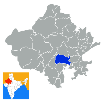
Bhilwara District is a district of the state of Rajasthan in western India. The town of Bhilwara is the district headquarters.
Geography and demographics
The district has an area of 10,455 km², and a population of 2,009,516 (2001 census), which increased 26.14% from 1991 to 2001. Famous for its textile & minerals Industries. It is bounded on the north by Ajmer District, on the east by Bundi District, on the south by Chittorgarh District, and on the west by Rajsamand District. State Highway (Jaipur-Udaipur) passes through the district, as does a broad gauge railway line measuring 84 km and connecting Ajmer with Khandwa in Madhya Pradesh. The nearest airport is at Udaipur (171 km).It is one of the best clean and green city of the India
Administrative set-up
There are 7 sub-divisions in the district: Bhilwara, Shahpura, Gangapur, Gulabpura, ASIND, Mandalgarh and Jahazpur. Under these sub-divisions there are 16 Tehsils: Bhilwara, Banera, Mandal, Mandalgarh, Beejoliya, Kotri, Shahpura, Jahazpur, Sahada, Raipur,Kareda, Asind, Hurda. FULIYAKALAN, SAHADA, BADNOR There are four Sub Tehsils also named Bagor (Mandal), Badnor (Asind), Hamirgarh (Bhilwara) and Puliakalan (Shahpura). Similarly there are 1783 villages as per census of 2001.
Demographics
According to the 2011 census Bhilwara district has a population of 2,410,459,[1] roughly equal to the nation of Kuwait[2] or the US state of New Mexico.[3] This gives it a ranking of 184th in India (out of a total of 640).[1] The district has a population density of 230 inhabitants per square kilometre (600/sq mi) .[1] Its population growth rate over the decade 2001-2011 was 19.7%.[1] Bhilwara has a sex ratio of 969 females for every 1000 males,[1] and a literacy rate of 62.71%.[1]This district also called Textile City or Manchester of India.
References
- 1 2 3 4 5 6 "District Census 2011". Census2011.co.in. 2011. Retrieved 2011-09-30.
- ↑ US Directorate of Intelligence. "Country Comparison:Population". Retrieved 2011-10-01.
Kuwait 2,595,62
- ↑ "2010 Resident Population Data". U. S. Census Bureau. Archived from the original on 2013-10-19. Retrieved 2011-09-30.
New Mexico - 2,059,179
External links
 |
Ajmer district | Tonk district | | |
| Rajsamand district | |
Bundi district | ||
| ||||
| | ||||
| Chittaurgarh district (Western) | Chittaurgarh district (Eastern) Neemuch district, Rajasthan |
| Outline |  | ||||||||||||||||||||||||||
|---|---|---|---|---|---|---|---|---|---|---|---|---|---|---|---|---|---|---|---|---|---|---|---|---|---|---|---|
| Governance | |||||||||||||||||||||||||||
| Divisions and Districts |
| ||||||||||||||||||||||||||
| Major cities | |||||||||||||||||||||||||||
| Related templates |
| ||||||||||||||||||||||||||
Coordinates: 25°21′N 74°38′E / 25.350°N 74.633°E