Bonneveau
| Bonneveau | ||
|---|---|---|
|
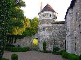
Château of Matval | ||
| ||
 Bonneveau | ||
|
Location within Centre-Val de Loire region  Bonneveau | ||
| Coordinates: 47°48′48″N 0°45′02″E / 47.8133°N 0.7506°ECoordinates: 47°48′48″N 0°45′02″E / 47.8133°N 0.7506°E | ||
| Country | France | |
| Region | Centre-Val de Loire | |
| Department | Loir-et-Cher | |
| Arrondissement | Vendôme | |
| Canton | Savigny-sur-Braye | |
| Intercommunality | Coteaux de la Braye | |
| Government | ||
| • Mayor (2014–2020) | Gérard Méry | |
| Area1 | 10.95 km2 (4.23 sq mi) | |
| Population (2013)2 | 490 | |
| • Density | 45/km2 (120/sq mi) | |
| Time zone | CET (UTC+1) | |
| • Summer (DST) | CEST (UTC+2) | |
| INSEE/Postal code | 41020 / 41800 | |
| Elevation |
65–154 m (213–505 ft) (avg. 133 m or 436 ft) | |
|
1 French Land Register data, which excludes lakes, ponds, glaciers > 1 km² (0.386 sq mi or 247 acres) and river estuaries. 2 Population without double counting: residents of multiple communes (e.g., students and military personnel) only counted once. | ||

Bonneveau is a commune in the Loir-et-Cher department in central France.
Population
| Historical population | ||
|---|---|---|
| Year | Pop. | ±% |
| 1793 | 448 | — |
| 1800 | 456 | +1.8% |
| 1806 | 543 | +19.1% |
| 1821 | 527 | −2.9% |
| 1831 | 561 | +6.5% |
| 1836 | 638 | +13.7% |
| 1841 | 545 | −14.6% |
| 1846 | 667 | +22.4% |
| 1851 | 596 | −10.6% |
| 1856 | 605 | +1.5% |
| 1861 | 575 | −5.0% |
| 1866 | 559 | −2.8% |
| 1872 | 530 | −5.2% |
| 1876 | 525 | −0.9% |
| 1881 | 505 | −3.8% |
| 1886 | 497 | −1.6% |
| 1891 | 466 | −6.2% |
| 1896 | 426 | −8.6% |
| 1901 | 451 | +5.9% |
| 1906 | 447 | −0.9% |
| 1911 | 440 | −1.6% |
| 1921 | 386 | −12.3% |
| 1926 | 380 | −1.6% |
| 1931 | 389 | +2.4% |
| 1936 | 395 | +1.5% |
| 1946 | 361 | −8.6% |
| 1954 | 385 | +6.6% |
| 1962 | 391 | +1.6% |
| 1968 | 387 | −1.0% |
| 1975 | 352 | −9.0% |
| 1982 | 486 | +38.1% |
| 1990 | 519 | +6.8% |
| 1999 | 465 | −10.4% |
| 2006 | 500 | +7.5% |
| 2009 | 508 | +1.6% |
See also
References
| Wikimedia Commons has media related to Bonneveau. |
This article is issued from Wikipedia - version of the 11/10/2016. The text is available under the Creative Commons Attribution/Share Alike but additional terms may apply for the media files.