Salbris
| Salbris | ||
|---|---|---|
|
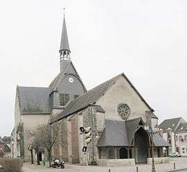
L'église Saint-Georges | ||
| ||
 Salbris | ||
|
Location within Centre-Val de Loire region  Salbris | ||
| Coordinates: 47°25′34″N 2°03′10″E / 47.4261°N 2.0528°ECoordinates: 47°25′34″N 2°03′10″E / 47.4261°N 2.0528°E | ||
| Country | France | |
| Region | Centre-Val de Loire | |
| Department | Loir-et-Cher | |
| Arrondissement | Romorantin-Lanthenay | |
| Canton |
Salbris (chef-lieu) | |
| Intercommunality | Communauté de communes La Sologne des rivières | |
| Government | ||
| • Mayor (2001–2008) | Jean-Pierre Albertini | |
| Area1 | 106.61 km2 (41.16 sq mi) | |
| Population (2006)2 | 5,777 | |
| • Density | 54/km2 (140/sq mi) | |
| Time zone | CET (UTC+1) | |
| • Summer (DST) | CEST (UTC+2) | |
| INSEE/Postal code | 41232 / 41300 | |
| Elevation | 96–131 m (315–430 ft) | |
|
1 French Land Register data, which excludes lakes, ponds, glaciers > 1 km² (0.386 sq mi or 247 acres) and river estuaries. 2 Population without double counting: residents of multiple communes (e.g., students and military personnel) only counted once. | ||
.svg.png)
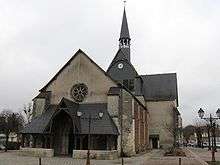
Saint George's church, Salbris
Salbris is a commune in the Loir-et-Cher department of central France.
See also
| Wikimedia Commons has media related to Salbris. |
This article is issued from Wikipedia - version of the 3/2/2015. The text is available under the Creative Commons Attribution/Share Alike but additional terms may apply for the media files.