Saint-Hilaire-la-Gravelle
| Saint-Hilaire-la-Gravelle | ||
|---|---|---|
|
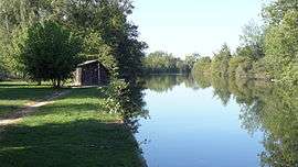
The Loir river | ||
| ||
 Saint-Hilaire-la-Gravelle | ||
|
Location within Centre-Val de Loire region  Saint-Hilaire-la-Gravelle | ||
| Coordinates: 47°55′31″N 1°12′27″E / 47.9253°N 1.2075°ECoordinates: 47°55′31″N 1°12′27″E / 47.9253°N 1.2075°E | ||
| Country | France | |
| Region | Centre-Val de Loire | |
| Department | Loir-et-Cher | |
| Arrondissement | Vendôme | |
| Canton | Morée | |
| Intercommunality | Haut Vendômois | |
| Government | ||
| • Mayor (2008–2014) | Ghislaine Engelhart | |
| Area1 | 17.57 km2 (6.78 sq mi) | |
| Population (1999)2 | 687 | |
| • Density | 39/km2 (100/sq mi) | |
| Time zone | CET (UTC+1) | |
| • Summer (DST) | CEST (UTC+2) | |
| INSEE/Postal code | 41214 / 41160 | |
| Elevation |
87–172 m (285–564 ft) (avg. 92 m or 302 ft) | |
|
1 French Land Register data, which excludes lakes, ponds, glaciers > 1 km² (0.386 sq mi or 247 acres) and river estuaries. 2 Population without double counting: residents of multiple communes (e.g., students and military personnel) only counted once. | ||
.svg.png)
Saint-Hilaire-la-Gravelle is a commune in the Loir-et-Cher department of central France.
See also
References
| Wikimedia Commons has media related to Saint-Hilaire-la-Gravelle. |
This article is issued from Wikipedia - version of the 3/2/2015. The text is available under the Creative Commons Attribution/Share Alike but additional terms may apply for the media files.