Bracieux
| Bracieux | ||
|---|---|---|
|
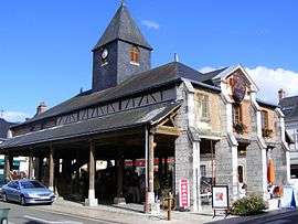
Covered market | ||
| ||
 Bracieux | ||
|
Location within Centre-Val de Loire region  Bracieux | ||
| Coordinates: 47°32′58″N 1°32′33″E / 47.5494°N 1.5425°ECoordinates: 47°32′58″N 1°32′33″E / 47.5494°N 1.5425°E | ||
| Country | France | |
| Region | Centre-Val de Loire | |
| Department | Loir-et-Cher | |
| Arrondissement | Blois | |
| Canton | Bracieux | |
| Intercommunality | Pays de Chambord | |
| Government | ||
| • Mayor (2014–2020) | Francis Guillot | |
| Area1 | 2.95 km2 (1.14 sq mi) | |
| Population (2013)2 | 1,269 | |
| • Density | 430/km2 (1,100/sq mi) | |
| Time zone | CET (UTC+1) | |
| • Summer (DST) | CEST (UTC+2) | |
| INSEE/Postal code | 41025 / 41250 | |
| Elevation |
74–89 m (243–292 ft) (avg. 80 m or 260 ft) | |
|
1 French Land Register data, which excludes lakes, ponds, glaciers > 1 km² (0.386 sq mi or 247 acres) and river estuaries. 2 Population without double counting: residents of multiple communes (e.g., students and military personnel) only counted once. | ||

Bracieux is a commune in the Loir-et-Cher department in central France.
Population
| Historical population | ||
|---|---|---|
| Year | Pop. | ±% |
| 1793 | 663 | — |
| 1800 | 643 | −3.0% |
| 1806 | 676 | +5.1% |
| 1821 | 825 | +22.0% |
| 1831 | 930 | +12.7% |
| 1836 | 976 | +4.9% |
| 1841 | 1,007 | +3.2% |
| 1846 | 1,090 | +8.2% |
| 1851 | 1,087 | −0.3% |
| 1856 | 1,054 | −3.0% |
| 1861 | 1,135 | +7.7% |
| 1866 | 1,174 | +3.4% |
| 1872 | 1,137 | −3.2% |
| 1876 | 1,163 | +2.3% |
| 1881 | 1,144 | −1.6% |
| 1886 | 1,139 | −0.4% |
| 1891 | 1,126 | −1.1% |
| 1896 | 1,117 | −0.8% |
| 1901 | 1,084 | −3.0% |
| 1906 | 1,139 | +5.1% |
| 1911 | 1,089 | −4.4% |
| 1921 | 1,009 | −7.3% |
| 1926 | 904 | −10.4% |
| 1931 | 846 | −6.4% |
| 1936 | 854 | +0.9% |
| 1946 | 866 | +1.4% |
| 1954 | 800 | −7.6% |
| 1962 | 793 | −0.9% |
| 1968 | 829 | +4.5% |
| 1975 | 1,011 | +22.0% |
| 1982 | 1,142 | +13.0% |
| 1990 | 1,157 | +1.3% |
| 1999 | 1,163 | +0.5% |
| 2006 | 1,265 | +8.8% |
| 2009 | 1,256 | −0.7% |
See also
References
| Wikimedia Commons has media related to Bracieux. |
This article is issued from Wikipedia - version of the 11/10/2016. The text is available under the Creative Commons Attribution/Share Alike but additional terms may apply for the media files.