Brahmanbaria District
| Brahmanbaria ব্রাহ্মণবাড়িয়া | |
|---|---|
| District | |
| Nickname(s): B-Baria, City of Brahmins | |
| Motto: "We shall rule Bengal" | |
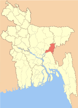 Location of Brahmanbaria in Bangladesh | |
| Coordinates: 23°59′N 91°07′E / 23.983°N 91.117°ECoordinates: 23°59′N 91°07′E / 23.983°N 91.117°E | |
| Country |
|
| Division | Chittagong Division |
| Capital | Brahmanbaria |
| Area | |
| • Total | 1,927.11 km2 (744.06 sq mi) |
| Population (2011 census)[1] | |
| • Total | 2,840,498 |
| • Density | 1,500/km2 (3,800/sq mi) |
| Demonym(s) | Beebarian, Brahmin |
| Time zone | BST (UTC+6) |
| Postal code | 3400 |
| Website |
www |
Brahmanbaria (Bengali: ব্রাহ্মণবাড়িয়া Bramhonbaŗia) is a district in east-central Bangladesh.
Administration and demographics
Brahmanbaria District, which was included in Comilla district (formerly Tipura district) was established in 1984. The district has 4 municipalities, 39 wards, 97 mahallas, 9 upazilas, 98 union parishads, 1081 mouzas and 1329 villages.
According to the 2011 Bangladesh census, Brahmanbaria District had 538,937 households and a population of 2,840,498.[1]
Education
Brahmanbaria is part of Comilla Board of Education. Brahmanbaria District has 6 colleges, one Engineering Institutes and one Medical colleges.
Subdivisions
Brahmanbaria district is divided into nine Subdivisions (previously known as Thanas or only one Towns) as below:
- Brahmanbaria Sadar Upazila
- Ashuganj Upazila
- Nasirnagar Upazila
- Nabinagar Upazila
- Sarail Upazila
- Kasba Upazila
- Akhaura Upazila
- Bancharampur Upazila
- Bijoynagar Upazila
Parliament constituencies
There are six Jatiyo Shangshad constituencies in Brahmanbaria district. These constituencies and the current Members of Parliament are:[2]
- National seat no 243 Brahmanbaria 1 (Current MP Mohammad Sayedul Haq,Minister of Fisheries)
- National seat no 244 Brahmanbaria 2 (Current MP Ziaul Haque Mridha)
- National seat no 245 Brahmanbaria 3 (Current MP R.A.M. Obaydul Muktadir Chowdhury)
- National seat no 246 Brahmanbaria 4 (Current MP, advocate Anisul Haq, Minister of Law)
- National seat no 247 Brahmanbaria 5 (Current MP, Fayzur Rahman)
- National seat no 248 Brahmanbaria 6 (Current MP A B Tajul Islam)
Economy
Brahmanbaria is one of the fastest growing districts in the country. The capital city of Brahmanbaria District is booming by new population of the southern Bangladesh. This city has the largest railway junction in the country which is Akhaura.[3]
Geography
Brahmanbaria District is mostly farmland. But within the district many cities can be found. The capital and largest city is Brahmanbaria. Akhaura and Ashuganj ranks also in top three. Prime minister of Bangladesh gave permission to use Ashuganj Port.[4] In addition, Akhaura Station will be connected to Agartala.[5]
References
- 1 2 "Population Census 2011: Brahmanbaria Table C-01" (PDF). Bangladesh Bureau of Statistics. Retrieved July 11, 2014.
- ↑ "বাংলাদেশ (Bangladesh) জাতীয় তথ্য বাতায়ন - গণপ্রজাতন্ত্রী বাংলাদেশ সরকার - People's Republic of Bangladesh". bangladesh.gov.bd.
- ↑ "AKA/Akhaura Junction Railway Station Map/Atlas – India Rail Info". India Rail Info.
- ↑ Press Trust of India (3 May 2014). "B'desh agrees to allow India use waterways to Ashuganj port". business-standard.com.
- ↑ "Government approves Rs 1,000 crore for India-Bangladesh rail link". timesofindia-economictimes.
External links
| Wikimedia Commons has media related to Brahmanbaria District. |
| Wikivoyage has a travel guide for Brahmanbaria District. |
 |
Kishoreganj District | Habiganj District | (India) | |
| Dhaka District | |
(Agartala, India) | ||
| ||||
| | ||||
| Narayanganj | Comilla District | (India) |
| Barisal Division |  | |
|---|---|---|
| Chittagong Division | ||
| Dhaka Division | ||
| Khulna Division | ||
| Mymensingh Division | ||
| Rajshahi Division | ||
| Rangpur Division | ||
| Sylhet Division | ||