Narayanganj District
| Narayanganj District নারায়ণগঞ্জ জেলা | |
|---|---|
| District | |
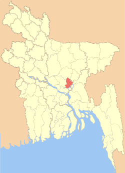 Location of Narayanganj District in Bangladesh | |
| Coordinates: BD 23°36′N 90°30′E / 23.60°N 90.50°ECoordinates: BD 23°36′N 90°30′E / 23.60°N 90.50°E | |
| Country |
|
| Division | Dhaka Division |
| Area | |
| • Total | 683.14 km2 (263.76 sq mi) |
| Population (2011 census) | |
| • Total | 2,948,217 |
| • Density | 4,300/km2 (11,000/sq mi) |
| Time zone | BST (UTC+6) |
| Postal code | 1400 |
Narayanganj District (Bengali: নারায়ণগঞ্জ জেলা pronounced: Naraeongônj Jela) is a district in central Bangladesh, part of the Dhaka Division.[1] The main city of the district is Narayanganj. It is near the capital city of Dhaka. The river port of Narayanganj is one of the oldest in Bangladesh. It is also a center of business and industry, especially the jute trade and processing plants, and the textile sector of the country. It is nicknamed the Dundee of Bangladesh due to the presence of many jute mills. Dundee was the first industrialised "Juteopolis" in the world.
History
Named after Bicon Lal Pandey, a Hindu religious leader who was also known as Benur Thakur or Lakhsmi Narayan Thakur. Pandey acquired ownership of the region from the British East India Company in 1766 after the Battle of Plassey. He declared the marketplaces on the banks of the Shitalakshya river as endowed property to pay for expenses for the worship of the God Narayan. Subsequently, the region was named Narayanganj.[1]
- Important developments
- The post office was established in 1866.
- The Narayanganj municipality was officially founded on 8 September 1876.
- Dhaka–Narayanganj telegraph service was set up in 1877.
- Telephony was introduced by the Bank of Bengal in 1882.
Narayanganj became a district (Bengali: জেলা pronounced: Jela) on 15 February 1984. Formerly, it was a subdistrict (Bengali: উপজেলা pronounced: upojela) of the Dhaka district. It grew in importance in the seventeenth and eighteenth century, due to the influx of the Portuguese and the English. The first to develop was the west bank of Shitalakshya. Narayanganj only became important in the nineteenth century, when the Rally Brothers started a company exporting jute to the west in 1830, aided by a company from Assam. By 1908, 18 European companies, and two Indian companies were trading in jute from Calcutta.[1]
From 1947, with the formation of Pakistan, the economy transformed from being mainly a jute production to include jute milling.[2] This followed the establishment of a number of mills in and around Narayanganj that gave the local economy a great boost.
Administrative area
Narayanganj Zila consists of 5 upazilas (Narayanganj Sadar, Bandor, Rupganj, Sonargaon and Araihazar), 47 unions and 827 mauzas. There are also 7 police stations here, which are: Narayanganj Sadar, Bandor, Fatulla, Sidhirganj, Rupganj, Sonargaon and Araihazar. Out of the five upazilas, Rupganj is the largest with an area of 247.97 km2 which is 32.65% of the total area of the zila. Bandar is the smallest with an area of 55.84 km2, sharing 7.34% of the total area of the zila. All the upazilas have more or less similar characteristics.
Administration
Subdistricts
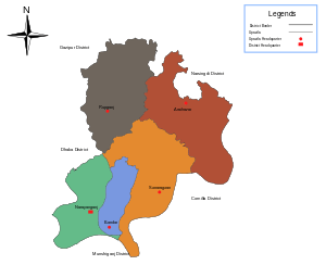
- Araihazar Upazila: 183.5 km2, 12 unions, 184 mauzas.
- Sonargaon Upazila: 171.66 km2, 11 unions, 352 mauzas.
- Bandar: 55.84 km2, 5 unions, 90 mauzas.
- Narayanganj Sadar Upazila: 100.75 km2, 10 unions, 55 mauzas.
- Rupganj Upazila: 247.97 km2, 9 unions, 146 mauzas.
Economy
The district pioneered in merchandising yarn and dyeing items. The cottage industry, like weaving, is abundant in this district. International trading, import and export business, shipyard brickfield, etc. create employment opportunities to the people which facilitate additional income to the household population. The small and medium industries of cotton are increasing day-by-day which fills the employment aids of the local people. The rural economy of Narayanganj is agriculture.
Religion
The district of Narayanganj has 3078 mosques, 269 temples, 10 churches and 4 Buddhist temples.
Places of interest
The ancient city of Sonargaon was the capital of Isa Khan, a medieval ruler of Bengal. Sonargaon is also famous for producing muslin, a delicate and fine cloth made from cotton. The Dhaka-Narayanganj-Demra (DND) embankment surrounds Narayanganj district and protects it from flooding.
- The Bangladesh Engineering and Ship Building Corporation at Sonakanda on the east bank of the Shitalakshya River, established in 1925.
Flora and fauna
Flora
Almost the whole of Narayanganj district lies on the meander flood plain. Most of this area is now flooded only by rain-water. Only minor areas near the Lakhya. Old Brahmaputra, Meghan, Shitalakha and Dhaleswari river are affected by river water and receive fresh silt deposits. A wide variety of soils occurs in this district.
Fauna
Mammals
Mammals that are commonly seen in the district are Indian pipistrelle (Pipistrellus coromandra).
Birds
The most common birds of the district include doel, salik, crow and duck.
Fish
In the river, canal, beels, and ponds there are various kinds of fish, but because of water pollution, it is very hard to see fish in the river.
See also
External links
References
| Wikimedia Commons has media related to Narayanganj District. |
- 1 2 3 Bhuiyan, Mokammal H (2012). "Narayanganj District". In Islam, Sirajul; Jamal, Ahmed A. Banglapedia: National Encyclopedia of Bangladesh (Second ed.). Asiatic Society of Bangladesh.
- ↑ Islam, Mufakharul (2012). "Jute Industry". In Islam, Sirajul; Jamal, Ahmed A. Banglapedia: National Encyclopedia of Bangladesh (Second ed.). Asiatic Society of Bangladesh.
- ↑ "AL men appointed administrators". The Daily Star. 16 February 2011. Retrieved 13 August 2012.
- ↑ Mohosinul Karim (30 April 2014). "Narayanganj gets new DC". Dhaka Tribune. Retrieved 16 February 2015.
| Barisal Division | 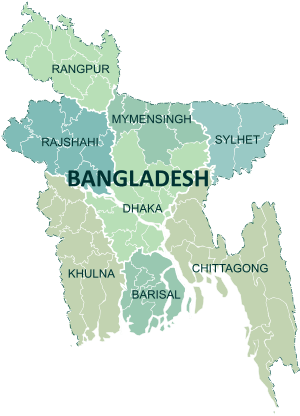 | |
|---|---|---|
| Chittagong Division | ||
| Dhaka Division | ||
| Khulna Division | ||
| Mymensingh Division | ||
| Rajshahi Division | ||
| Rangpur Division | ||
| Sylhet Division | ||