Magura District
| Magura মাগুরা | |
|---|---|
| District | |
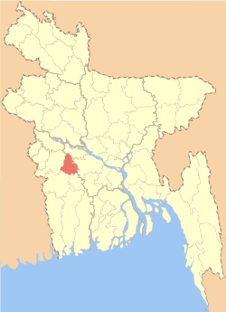 Location of Magura in Bangladesh | |
| Coordinates: BD 23°24′N 89°24′E / 23.40°N 89.40°ECoordinates: BD 23°24′N 89°24′E / 23.40°N 89.40°E | |
| Country |
|
| Division | Khulna Division |
| Area | |
| • Total | 1,048.61 km2 (404.87 sq mi) |
| Population (2011 census) | |
| • Total | 918,419 |
| • Density | 880/km2 (2,300/sq mi) |
| Literacy rate | |
| • Total | 28.5% |
| Time zone | BST (UTC+6) |
| Postal code | 7600 |
Magura (Bengali: মাগুরা জেলা) is a district in south-western Bangladesh. It is a part of the Khulna Division.[1] Magura is far from Dhaka by 176 kilometers. The main Transport is bus. From Magura to Dhaka it takes five hours by bus. There is no train transport in Magura.
Geography
Magura District (Khulna Division) with an area of 1048 km2, is bounded by Rajbari district to the north, Jessore and Narail districts to the south, Faridpur district to the east and Jhenaidaha district to the west.
Climate
| Climate data for Magura | |||||||||||||
|---|---|---|---|---|---|---|---|---|---|---|---|---|---|
| Month | Jan | Feb | Mar | Apr | May | Jun | Jul | Aug | Sep | Oct | Nov | Dec | Year |
| Average high °C (°F) | 23.4 (74.1) |
27.7 (81.9) |
33.3 (91.9) |
35.6 (96.1) |
34.8 (94.6) |
32.4 (90.3) |
31.4 (88.5) |
31.4 (88.5) |
32.2 (90) |
31.4 (88.5) |
28.9 (84) |
25.5 (77.9) |
30.67 (87.19) |
| Daily mean °C (°F) | 16.4 (61.5) |
20.2 (68.4) |
26.0 (78.8) |
29.2 (84.6) |
29.6 (85.3) |
28.9 (84) |
28.4 (83.1) |
28.6 (83.5) |
28.8 (83.8) |
27.3 (81.1) |
23.2 (73.8) |
18.7 (65.7) |
25.44 (77.8) |
| Average low °C (°F) | 9.4 (48.9) |
12.8 (55) |
18.7 (65.7) |
22.9 (73.2) |
24.5 (76.1) |
25.5 (77.9) |
25.5 (77.9) |
25.8 (78.4) |
25.6 (78.1) |
23.3 (73.9) |
17.5 (63.5) |
12.0 (53.6) |
20.29 (68.52) |
| Average precipitation mm (inches) | 11 (0.43) |
19 (0.75) |
40 (1.57) |
85 (3.35) |
183 (7.2) |
323 (12.72) |
302 (11.89) |
288 (11.34) |
242 (9.53) |
156 (6.14) |
25 (0.98) |
7 (0.28) |
1,681 (66.18) |
| Average relative humidity (%) | 45 | 35 | 32 | 48 | 66 | 74 | 75 | 74 | 71 | 66 | 47 | 44 | 56.4 |
| Source: National newspapers | |||||||||||||
Administration
Magura district has 4 upazilas. They are:
Notable residents
- Akbar Hossain Miah, organizer of the guerilla Akbar Bahini during the War of Independence, 1971.[2][3]
- Didar Islam, innovator and founder of "SOLARIC" [4][5]
- Farrukh Ahmed, Poet
- Mohammad Lutfur Rahman, Author
- Syed Ali Ahsan, Poet
- Kazi Kader Newaj, Poet
- Shakib Al Hasan, cricketer
References
| Wikimedia Commons has media related to Magura District. |
- ↑ Abu Naser Majnu (2012). "Magura District". In Sirajul Islam and Ahmed A. Jamal. Banglapedia: National Encyclopedia of Bangladesh (Second ed.). Asiatic Society of Bangladesh.
- ↑ "LGED MAGURA , About MAGURA". Local Government Engineering Department. Retrieved 9 May 2015.
- ↑ Seraj, Hossain (9 March 2015). "Magura people recall memoir of War ahead of Independence Day". The Daily Observer. Retrieved 9 May 2015.
- ↑ http://www.solar-ic.com http://solar-ic.com/solaricdev/about/solaric-360-degree/
- ↑ http://www.thedailystar.net/solaric-takes-green-energy-tech-to-next-level-38680
| Upazila/Thana: | ||
|---|---|---|
| Barisal Division | 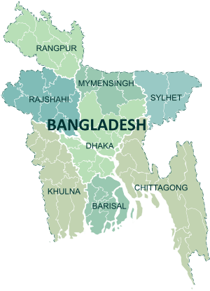 | |
|---|---|---|
| Chittagong Division | ||
| Dhaka Division | ||
| Khulna Division | ||
| Mymensingh Division | ||
| Rajshahi Division | ||
| Rangpur Division | ||
| Sylhet Division | ||
This article is issued from Wikipedia - version of the 9/1/2016. The text is available under the Creative Commons Attribution/Share Alike but additional terms may apply for the media files.