Mymensingh District
| Mymensingh ময়মনসিংহ | |
|---|---|
| District | |
|
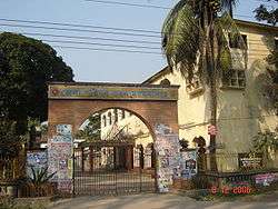
Office of the District Commissioner of Mymensingh | |
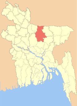 Location of Mymensingh in Bangladesh | |
| Coordinates: BD 24°38′3″N 90°16′4″E / 24.63417°N 90.26778°ECoordinates: BD 24°38′3″N 90°16′4″E / 24.63417°N 90.26778°E | |
| Country |
|
| Division | Mymensingh Division |
| Government | |
| • District Commissioner | Md. Shah Alam Bakshi |
| Area | |
| • Total | 4,363.48 km2 (1,684.75 sq mi) |
| Population (2011 census) | |
| • Total | 5,110,272 |
| • Density | 1,200/km2 (3,000/sq mi) |
| Time zone | BST (UTC+6) |
| Postal code | 2200 |
Mymensingh (Bengali: ময়মনসিংহ) is one of the districts of Mymensingh division, Bangladesh, and is bordered on the north by Meghalaya state of India and Garo Hills, on the south by Gazipur district, on the east by districts of Netrokona and Kishoreganj, and on the west by districts of Sherpur, Jamalpur and Tangail.[1] Mymensingh town is the district headquarters.
Geography
The district covers an area of 4363.48 km2, with several small valleys between high forests. The temperature ranges from 12 to 33 °C, and the annual rainfall averages 2,174 mm. It is at the foot of Garo hills of Meghalaya, and includes some chars (sandy islands) founded on the bed of the Old Brahmaputra River and also some ancient forests of mainly a single wood tree, the sal tree. The city of Mymensingh stands on the bank of the Old Brahmaputra, as the 1897 Assam earthquake changed the main flow from Brahmaputra to the Jamuna River which flows west of the greater Mymensingh region. After about hundred years, a port city of sea vessels from England lost its status as the river became a seasonal flow. Some former residences of colonial officials along the side of the river in the city are nowadays government buildings. The area of Greater Mymensingh, the north front line is just at the foot of Garo hills of Meghalaya of India, the south this area excludes The Gazipur district, the east ends in the rich watery land of Bangladesh as native calls 'Hawor', the west ends in the ancient single wood forest (e.g. Muktagacha, Fulbaria and Valuka Upozillas) and the Chars of Jamalpur district sided north-west of Mymensingh district.
Climate
| Climate data for Mymensingh | |||||||||||||
|---|---|---|---|---|---|---|---|---|---|---|---|---|---|
| Month | Jan | Feb | Mar | Apr | May | Jun | Jul | Aug | Sep | Oct | Nov | Dec | Year |
| Average high °C (°F) | 24.0 (75.2) |
27.7 (81.9) |
31.8 (89.2) |
33.4 (92.1) |
32.1 (89.8) |
31.0 (87.8) |
31.2 (88.2) |
31.2 (88.2) |
31.1 (88) |
30.8 (87.4) |
28.7 (83.7) |
25.8 (78.4) |
29.9 (85.83) |
| Daily mean °C (°F) | 17.5 (63.5) |
20.7 (69.3) |
25.1 (77.2) |
27.8 (82) |
27.9 (82.2) |
28.0 (82.4) |
28.5 (83.3) |
28.5 (83.3) |
28.4 (83.1) |
27.2 (81) |
23.4 (74.1) |
19.6 (67.3) |
25.22 (77.39) |
| Average low °C (°F) | 11.0 (51.8) |
13.8 (56.8) |
18.4 (65.1) |
22.3 (72.1) |
23.7 (74.7) |
25.0 (77) |
25.8 (78.4) |
25.8 (78.4) |
25.5 (77.9) |
23.6 (74.5) |
18.2 (64.8) |
13.5 (56.3) |
20.55 (68.98) |
| Average precipitation mm (inches) | 12 (0.47) |
17 (0.67) |
46 (1.81) |
110 (4.33) |
286 (11.26) |
469 (18.46) |
401 (15.79) |
398 (15.67) |
311 (12.24) |
179 (7.05) |
18 (0.71) |
2 (0.08) |
2,249 (88.54) |
| Average relative humidity (%) | 42 | 36 | 32 | 46 | 61 | 75 | 74 | 75 | 72 | 68 | 55 | 46 | 56.8 |
| Source: National newspapers | |||||||||||||
History
Maimansingh, a district of British India, is in the Maimansingh division of Eastern Bengal and Assam. It occupies a portion of the alluvial valley of the Brahmaputra east of the main channel (called the Jamuna) and north of Dacca. The administrative headquarters are at Nasirabad, usually called Mymensingh town. Area, 6332 sq mi Pop. (1901) 3,915,068, showing an increase of 12.8% in the decade. The district is for the most part level and open, covered with well-cultivated fields, and intersected by numerous rivers.
The district was acquired by the East India Company with the Dewani Grant from the Mughal Emperor in 1765. At that time its greater part was included in the Niabat (Sub-Province of Dhaka and a small portion in the Zamindaries of Atia, Kagmari, Pukuria and Patilandaha (of Rahahahi Zamindari). At the time of Permanent Settlement, it included northwest Garo-Hills and the Brahmandaria Subdivision of the Present Comilla district but did not include north Tangail and north-west part of Jamalpur. In 1799 Taluk Amirabad was transferred to Tippera (Comilla). In 1809, Patiladaha, situated north-east of the Brahmaputra came to district form Rangpur. In 1811, the river Banar and Brahmaputra were declared boundary between Dhaka and Mymensingh district and the river Brahmaputra and Meghna as boundary between Tippera (now Comilla) and Mymensingh and Dhaka. In 1811 west Gar-Hills were transferred to Rangpur district. In 1812 Patiladaha, was retransferred to Rangpur. In 1830, Parganas Sarail, Daudpur, haripur, Bejra, and Satarakhandal, were transferred to Tippera and Public convenience. In 1855, due to change in river course part or Serajganj thana was transferred from Mymensingh to Pabna and in 1866, the whole of it was transferred to Pabna. In 1866, thana Dewangajn was transferred to Mymensingh form Bogra and thana Atia from Dhaka. In 1867 for the administrative convenience boundaries of five subdivisions (including Tangail) and thanaswere notified. In 1874 on the basis of survey, the district boundaries were notified. In 1874 the Jamuna (or Daokoba) River was declared the western boundary between Mymensingh and Bogra and as such, 165 villages were transferred to Bogra. In 1875, the Brahmaputra was Made the boundary between Mymensingh and Rangpur and the portion of patiladaha, east of the river, was transferred to this district form Rangpur. In 1877, the Jamuna was declared the boundary between Pabna and Mymensingh, in the west. On the first of December, 1969, Tangail subdivision was separated from Mymensingh and a new District of Tangail was formed.[2]Then in 1977 another new district Jamalpur (including Sherpur) was formed.
Forests
The Madhupur jungle is a slightly elevated tract, extending from the north of Dhaka district into the heart of Mymensingh; its average height is about 60 ft above the level of the surrounding country, and it nowhere exceeds 100 ft. The jungle contains abundance of sal, valuable both as timber and charcoal. The main benefits of sal is that it can absorb carbon more than any other native trees, so it helps mitigate the severe pollution of Dhaka city. The only other elevated tract in the district is on the northern border, where the Susang Durgapur situated in Netrokona district (part of Greater Mymensingh). Actually the Haluaghat upozilla of Mymensingh is border with India and Garo hills of Meghalaya. They are for the most part covered with thick thorny jungle, but in parts are barren and rocky.
Rivers
The Jamuna forms the western boundary of Mymensingh for a course of 94 m. It is navigable for large boats throughout the year; and during the rainy season it expands in many places to 5–6 m in breadth. The Brahmaputra enters Mymensingh at its north-western corner near Karaibari, and flows south-east and south until it joins the Meghna a little below Bhairab Bazar. The gradual formation of chars and bars of sand in the upper part of its course (mainly influenced by The Great Assam Bengal Earthquake 1897) has diverted the main volume of water into the present channel of the Jamuna, which has in consequence become of much more importance than the Brahmaputra proper. The Meghna only flows for a short distance through the south-east portion of the district, the eastern and south-eastern parts of which abound in marshes.
Railroads
A branch line of the Eastern Bengal railway runs north from Dhaka through Nasirabad etc.
Timeline
- 1772 1790 Fakir and Sannyasi revolt
- 1787 Floods
- 1788 Famines
- 1897 Earthquake
- 1905 Swadeshi Movement
- 1947 Breakdown of British India
- 1971 Liberation war
- 2015 8th division of Bangladesh
Subdistricts/Upazillas
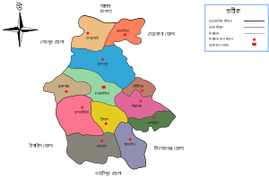
Mymensingh district was established in 1787,[3] which was later on reorganized into six districts, namely, Tangail, Jamalpur, Kishoreganj, Sherpur, Netrokona, and Mymensingh. Currently, Mymensingh district has a city corporation, eight municipalities and thirteen Upazilas.
| No. | Upazila (subdistrict) name | Area (square kilometer) | Population |
| 1 | Bhaluka | 444.05 | 264,991 |
| 2 | Trishal | 338.98 | 336,797 |
| 3 | Haluaghat | 356.07 | 242,339 |
| 4 | Muktagachha | 314.71 | 321,759 |
| 5 | Dhobaura | 251.05 | 157,027 |
| 6 | Fulbaria | 402.41 | 345,283 |
| 7 | Gaffargaon | 401.16 | 379,803 |
| 8 | Gauripur | 374.07 | 247,945 |
| 9 | Ishwarganj | 286.19 | 306,977 |
| 10 | Mymensingh Sadar | 388.45 | 566,368 |
| 11 | Nandail | 326.13 | 328,847 |
| 12 | Phulpur | 580.21 | 459,046 |
| 13 | Tarakanda | ----1 | ----- |
Town
Mymensingh town, earlier known as Nasirabad, is placed on the west bank of Brahmaputra River. The population is around 225,811. Having Bangladesh Agricultural University,[4] Mymensingh Engineering College, Teachers Training College-Women, Teachers Training College-Both, Government Laboratory High School, Mymensingh Zilla School, Govt. Mumenunnesa College, Ananda Mohan College, huge bridge on Brahmaputra river, 2 medical colleges (Mymensingh Medical College,[5] Community Based Medical College), 8 high schools, Raj bari, natural beauty of farm lands, etc., Mymensingh is one of the best places for living and educating children in Bangladesh. Because there are very few fuel run-vehicles, sound pollution and air pollution levels are very low. It is also one of the best towns in Bangladesh to educate child up to grade ten. There is no public boys college in Mymensingh town; however, every years lots of students from this town get admission in different universities and medical college in Bangladesh. The first military high school for girls in the country, Mymensingh Girls Cadet College, is also located in Mymensingh town. A huge amount of land occupied by various churches in Mymensingh city in relation to number of followers.
Religious institutions include 2,362 mosques, 1,020 temples, 600 Buddhist temples, and 36 churches.
References
| Wikimedia Commons has media related to Mymensingh District. |
- ↑ Samar Pal (2012). "Mymensingh District". In Sirajul Islam and Ahmed A. Jamal. Banglapedia: National Encyclopedia of Bangladesh (Second ed.). Asiatic Society of Bangladesh.
- ↑ Bangladesh District Gazetters Mymensingh
- ↑ The Central Administration of the East India Company 1773–1834
- ↑ Encyclopædia Britannica
- ↑ Mymensingh Medical College website
-
 This article incorporates text from a publication now in the public domain: Chisholm, Hugh, ed. (1911). "Mymensingh". Encyclopædia Britannica (11th ed.). Cambridge University Press.
| Barisal Division | 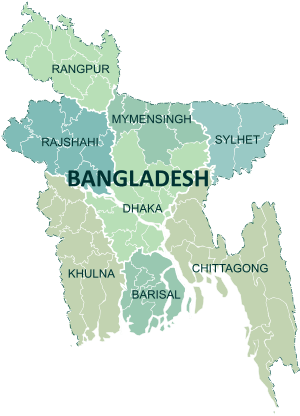 | |
|---|---|---|
| Chittagong Division | ||
| Dhaka Division | ||
| Khulna Division | ||
| Mymensingh Division | ||
| Rajshahi Division | ||
| Rangpur Division | ||
| Sylhet Division | ||