Natore District
| Natore নাটোর | |
|---|---|
| District | |
|
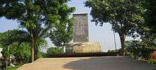
Uttara Gano Bhaban, earlier known as Natore Rajbari, is now used as the Prime Minister's local residence and office in the northern region of Bangladesh | |
 Location of Natore in Bangladesh | |
| Coordinates: BD 24°25′N 88°56′E / 24.41°N 88.93°ECoordinates: BD 24°25′N 88°56′E / 24.41°N 88.93°E | |
| Country |
|
| Division | Rajshahi Division |
| Area | |
| • Total | 1,900.19 km2 (733.67 sq mi) |
| Population (2011 census) | |
| • Total | 1,706,673 |
| • Density | 900/km2 (2,300/sq mi) |
| Time zone | BST (UTC+6) |
.JPG)
Natore is a district of Rajshahi Division[1] located in northern Bangladesh. It borders the metropolitan city of Rajshahi, and used to be part of Rajshahi district.
Origin of name
At first Natore was a beel (a large water body) whose name was Chaivhanga. In 1706 Raja Ramjibon Rai established his capital here by filling the beel. Up until 1821 Natore was the central office of Rajshahi district. In 1845 Natore Mahakuma was established. Natore Municipality was established in 1869. Natore became a fullfledged district in 1984. “Indigo resistance” movements took place in this district during 1859 and 1860.
Geography
Most part of Natore district is plain land. Chalan Beel, the largest beel in Bangladesh is in part of Natore district.
Natore District (Rajshahi division) with an area of 1896.05 km², is bordered by Naogaon and Bogra districts to the north, Pabna and Kushtia districts to the south, Pabna and Sirajganj districts to the east, Rajshahi district to the west. The road distance from Natore to Dhaka is 220 kilometres. Lalpur is the lowest Average annual rainfall area of Bangladesh.
Infrastructure
Communication facilities: Roads: pucca 236.04 km, semi pucca 35 km and mud road 1703.85; railways 64 km.
NGO activities Operationally important NGOs are BRAC, CARE, Grameen Bank, ITCL, Thengamara Mahila Sabuj Sangha (TMSS) etc.
Administrative structure
Upazilas
Natore was the District HQ of Rajshahi since 1769-1825. At the eve of that replacement,Natore was declared as a Subdivision; that's why Natore is the first Subdivision of Bangladesh. Natore was established as a district in 1984.
There are seven upazilas in the district:[1][2]
- Gurudaspur Upazila
- Natore Sadar Upazila
- Baraigram Upazila
- Bagatipara Upazila
- Lalpur Upazila
- Singra Upazila
- Naldanga Upazila
Pourasavas
There are eight (8) pourasavas in Natore district, 4 of them being the seat of upazilas (sub-districts). They are:
- Natore (Natore Upazila)
- Singra
- Boraigram (Baraigram Upazila)
- Gurudaspur
- Bagatipara (Bagatipara Upazila)
- Gopalpur (Lalpur Upazila)
- Naldanga (Naldanga Upazila)
- Bonpara (Baraigram Upazila)
- LALPUR
Natore town
The town has a population of 72615; male 51.57%, female 48.43%; density of population is 4825.Chalkbuddhnath,Station bajar,Borgasa, Alaipur, Kanaikhali, Nichabazar, Lalbazar, Madrasamor, Bongojal are the most populated areas of Natore Town.
Mayor : Alhaz Sheikh Emdadul Haque Al-Mamun.
Administration
Deputy Commissioner (DC): Muhammad Moshiur Rahman
Superintendent of Police (SP): Bashudeb Banik
Administrator of Zila Porishod: Advocate Sajedur Rahman Khan
Notable persons
- Farida Parveen, Bangladeshi folk singer
- Zunaid Ahmed Palak - MP
- Maharanee Bhabanee (1715–1802) was an Independent Jamindar of Natore during British India.[3]
- Jadunath Sarkar (1870–1958)
- Banalata Sen of Natore (fictional character)
- Kumar Sharatkumar Roy (1876–1946)
- Sarafat-ullah Talukder (1900–1996)
- Shree Shongkor Gobinda - MP
History
Natore was the District Headquarters of Rajshahi since 1769-1825.[4] Administrative Natore subdivision was established in 1825 under Rajshahi district, on the eve of the shifting of the HQ.
During the Bangladesh Liberation War in 1971 a direct battle was fought between the Pakistani occupation army and the freedom fighters of Mukti Bahini on 29 March in which about 40 members of the Pakistani army including Major Aslam and Captain Ishaq were killed. On 5 May 1971 Pakistani Army killed 42 employees of North Bengal Sugar Mills (Lalpur) including the then General Manager of the mill, Lieutenant Anwarul Azim; they were killed near a pond in the mill campus. The pond is now known as "Shaheed Sagar" and there is a memorial beside the pond.
Marks of the War of Liberation: Mass grave 5, memorial 1.
Economy
Population 1521359. Sectoral share of occupations are Agriculture 41.75%, agricultural laborer 28.84%, wage laborer 3.01%, commerce 10%, service 5.02%, fishing 1.32% and others 10.06%. Economy of Natore is based on agriculture.
There are 2 sugar mills in Natore: 1. Natore Sugar Mills Limited 2. North Bengal Sugar Mills Limited. Natore Sugar Mills Limited, Natore Sadar, Natore (1985), Natore Sugar Mills Limited is 2.5 kilometres (1.6 mi) from Natore town. North Bengal Sugar Mills Limited, Lalpur, Natore (1933). This two sugar mills are the enterprises of the Bangladesh Sugar & Food Industries Corporation (BSFIC). Pran Agro Ltd., Ekdala, Natore Sadar (2005) is a private food manufacturing plant of Pran-RFL Group. Jamuna Distillery Limited (1995)is another private industry of Jamuna Group, the distillery produces industrial alcohol, the Distillery is situated near Natore Sugar Mills Limited. More industries will be set up if gas is supplied through pipeline in Natore. That's why it is becoming a public demand to supply gas through pipeline as soon as possible.
Hats, bazaars and fairs
Total number of hats and bazaars are 152, fairs 13. Tebaria Hat, which is situated 3 km from Natore town is a traditional hat which sits every Sunday. Tebaria is the biggest Hat of Natore.
Exports
Main exports are sugar, paddy and vegetables.
Transportation
- Roads & Highways:
Natore in literature
Famous romantic poet of Bengal , Jibanananda Das has written a poem named Banalata Sen regarding one "Banalata Sen from Natore".
.JPG)
Places of interest
Tourist attractions in Natore include Rani Bhabanir Rajbari, the palace of Queen Bhabani. Rani Bhabani was a great social worker.[5] She was the pioneer to spread education for the women of Bengal. It is a historical palace, situated in the Bongojol area nearby Natore zero (Madrasamore/old bus stand). There is a college, a school, and other institutions named after Rani Bhobani. Rani Bhabanir Rajbari is surrounded by a wonderful lake, which beautifies this area.
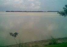
Chalan Beel is a large natural wetland. During the monsoon, the area of the Bil increases and touches four upazilas (sub-districts) of the Natore district. The picnic parties come to Cholon Bil every season. They cook, sing, dance, and do everything they wish in their boats. It looks like a sea, especially during the monsoon.
Dighapatiya Rajbari is the most popular sight with visitors. The kings of Natore lived here. Today, it is called Uttara Gano Bhaban, and is one of the official residences of the president of Bangladesh. It is situated in large grounds, with decorative gates, a large garden, and hundreds of rooms. There is a lake surrounded proper palace area and some spectacular sculpture here. It is 3km distance from Natore Zero point district town.

Other places to visit include:
- Natore Rajbari
- Uttara Gonobhaban
- Halti Beel (mini Cox-bazar)
- Pagla Raja's Palace (jubo park)
- Palace of Bagatipara Upazila
- Modoner Pukur Par
- Natore Adhunik Stadium
- Maharaja's Palace
- Beautiful village of Moshinda
- Natore Sugar Mills
- North Bengal Sugar Mills and the "Shaheed Sagar" memorial on the mill campus.
- Pran-Agro Limited
- Chalan Beel
- St.Merry Catholic Church which is situated at Boraigram.
See also
References
| Wikivoyage has a travel guide for Natore District. |
| Wikimedia Commons has media related to Natore District. |
- 1 2 Md. Rezaul Karim (2012). "Natore District". In Sirajul Islam and Ahmed A. Jamal. Banglapedia: National Encyclopedia of Bangladesh (Second ed.). Asiatic Society of Bangladesh.
- ↑ Mohammad Zakaria (21 May 2014). "59.47% vote in 6th phase upazila polls". Dhaka Tribune. Retrieved 23 November 2014.
- ↑ William Hunter , Annals of Rural Bengal.
- ↑ Natoer Gaurab ( The Glory of Natore), edited by Md. Mokshuder Rahman, A Publication of Natore District Administration,December 1989.
- ↑ ABM Mahmood (2012). "Rani Bhabani". In Sirajul Islam and Ahmed A. Jamal. Banglapedia: National Encyclopedia of Bangladesh (Second ed.). Asiatic Society of Bangladesh.
| Barisal Division | 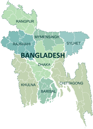 | |
|---|---|---|
| Chittagong Division | ||
| Dhaka Division | ||
| Khulna Division | ||
| Mymensingh Division | ||
| Rajshahi Division | ||
| Rangpur Division | ||
| Sylhet Division | ||