Cadet, Missouri
| Cadet, Missouri | |
|---|---|
| Unincorporated community | |
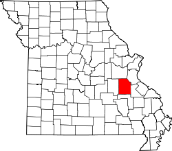 Location of Cadet, Missouri | |
| Country | United States |
| State | Missouri |
| County | Washington |
| Elevation | 801 ft (244 m) |
| Time zone | Central (CST) (UTC-6) |
| • Summer (DST) | CDT (UTC-5) |
| ZIP code | 63630 |
| Area code(s) | 573 |
Cadet is an unincorporated community in Union Township in eastern Washington County, Missouri, United States. It is located on Route 47 about 6 miles (10 km) northeast of Potosi.[1][2] The origin of its name is unknown. Cadet was founded in 1857 when the St. Louis, Iron Mountain and Southern Railway was built.
Geography
Elevation 801 feet. Land Area: 70.45 square miles Water Area: 0.32 square miles Latitude: 38.020743 Longitude: -90.745575 37°59′15″N 90°41′18″W / 37.98750°N 90.68833°W
References
External links
Municipalities and communities of Washington County, Missouri, United States | ||
|---|---|---|
| Cities | | |
| Villages | ||
| Townships |
| |
| Unincorporated communities | ||
Coordinates: 37°59′15″N 90°41′18″W / 37.98750°N 90.68833°W
This article is issued from Wikipedia - version of the 8/19/2014. The text is available under the Creative Commons Attribution/Share Alike but additional terms may apply for the media files.