Central Circular Route (Shuto Expressway)

The Central Circular Route (中央環状線 Chūō Kanjō-sen), signed as Route C2, is one of the routes of the Shuto Expressway system serving the central part of the Greater Tokyo Area. The route is a circumferential highway running through the outer wards of Tokyo. The route is the middle of three ring expressways planned for the city; the other two being the C1 Inner Circular Route and the C3 Tokyo Gaikan Expressway.
The complete route is 48.8 km in length. Construction work on underground sections of the route began in 1992 with the final section opened to traffic on 7 March, 2015. Given the extensive tunneling and engineering challenges involved construction costs for the route were estimated to be 2 Trillion yen.[1]
The route is approximately 8km from the center of the city and goes through the wards of Edogawa, Katsushika, Adachi, Kita, Itabashi, Toshima, Shinjuku, Nakano, Shibuya, Meguro, and Shinagawa.
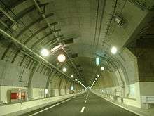
The Yamate Tunnel forms a key part of the Central Circular Route. A deep underground tunnel constructed beneath Yamate Dori, the first section over 11km in length, was opened to traffic on December 22, 2007. From 2010 the tunnel extended the Central Circular Route south from near Ikebukuro to Ohashi Junction connecting with Route 3. The last 9.4 km through Meguro and Shinagawa was opened to traffic on March 7, 2015.[2] When this last section of the tunnel opened the Yamate Tunnel formed Japan's longest, and the world's second longest road tunnel.[3] During the tunnel's first week of operations, traffic volume on the Inner Circular Route was reduced by seven percent from the previous week, and congestion on expressways inside the Central Circular Route (an index measured by recording segments where average traffic speed is less than 40 km/h, and multiplying the affected distance by the affected time) was approximately halved from the previous week.[4]
The C2 begins and ends at the Bayshore Route, which serves to close the loop.
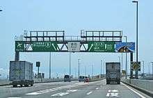
Exit List
List of currently existing interchanges and exits ordered following the outer loop (clockwise):
| Municipality | Exit/interchange name | Destinations | Notes |
|---|---|---|---|
| Shinagawa-ku | Ōi JCT | Bayshore Route | |
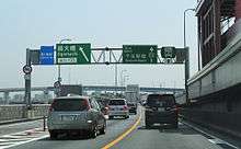
| Meguroku-ku | Ōhashi JCT | Route 3 (Shuto Expressway) Outbound to Yoga and Tōmei Expressway. Inbound to Tanimachi from Inner Loop. | |
| Shibuya-ku | Tomigaya C22 |
||
| Shibuya-ku | Hatsudai-Minami C23 |
||
| Shinjuku-ku | Nishi-shinjuku JCT | Route 4 Outbound to Takaido and Chūō Expressway. Inbound to Miyakezaka from Inner Loop. | |
| Nakano-ku | Nakano-chojabashi C24 |
Shinjuku Station, Tokyo Metropolitan Government Office | Inner loop exit/outer loop entrance only |
| Shinjuku-ku | Naka-ochiai JCT (Planned) | Planned Nerima Route outbound to Nerima and Kan-etsu Expressway. | Tokyo Metropolitan Expressway Corporation plans to connect between C2 and Kan-estu Expressway through Nerima Route. |
| Toshima-ku | Nishi-ikebukuro Entrance C25 |
Ikebukuro Station | Inner loop entrance/outer loop exit only |
| Toshima-ku | Nishi-ikebukuro Exit C26 |
Ikebukuro Station | Inner loop exit. |
| Itabashi-ku | Takamatsu Entrance C28 |
Yamate-dori street | Outer loop entrance only. Inner loop exit has closed and moved to Nishi-ikebukuro in 2007, due to the extension of Yamate Tunnel. |
| Itabashi-ku | Kumanocho JCT | Route 5 inbound to Higashi-ikebukuro and Takebashi JCT from Inner loop.
Route C2 Outer Loop to Route 5 inbound is not connected. |
inbound only |
| Itabashi-ku | Itabashi JCT | Route 5 outbound to Ōmiya and Kan-etsu Expressway via Tokyo Gaikan Expressway. | outbound only |
| Itabashi-ku | Shin-itabashi C29 |
National Route 17, also known as Nakasendō avenue | Outer loop exit only |
| Itabashi-ku | Takinogawa C31 |
National Route 17, also known as Nakasendō avenue | Inner loop entrance only |
| Kita-ku | Ōji-minami C33 |
Ōji Station, Asukayama Park. | Under construction: Inner loop entrance/outer loop exit. This interchange is currently being reconstructed into a full interchange in combination with Oji-kita Rampway. |
| Kita-ku | Ōji-kita C34 |
Ōji Station, Asukayama Park. | Inner loop exit/outer loop entrance Note: this interchange is currently being reconstructed into a full interchange in combination with Oji-minami Rampway. |
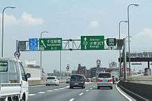
| Adachi-ku | Kōhoku JCT | Route S1 to Angyō and Tōhoku Expressway | |
| Adachi-ku | Ogiohashi C35, C36 |
||
| Adachi-ku | Senju-shimbashi C37, C38 |
Kita-senju Station, National Route 4, also known as Nikkō Kaidō avenue | |
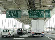
| Katsushika-ku | Kosuge JCT | Route 6 outbound to Misato and Jōban Expressway | |
| Katshushika-ku | Kosuge C40 |
Inner loop exit/outer loop entrance | |
| Katshushika-ku | Horikiri JCT | Route 6 inbound to Ginza and Hakozaki | |
| Katsushika-ku | Yotsugi C41, C42 |
National Route 6, also known as Mito Kaidō avenue | |
| Katsushika-ku | Hirai-ōhashi C43 |
Outer loop exit/inner loop entrance | |
| Edogawa-ku | Komatsugawa JCT (Planned) | Crosses over Route 7 without connection. Tokyo Metropolitan Expressway Corporation plans to connect between C2 inner loop and route 7 inbound. | |
| Edogawa-ku | Funaboribashi C44 |
Inner loop exit/outer loop entrance | |
| Edogawa-ku | Seishinchō C45 |
Outer loop exit/inner loop entrance This freeway stub will become part of Route 10 | |
| Edogawa-ku | Kasai JCT | Bayshore Route East to Urayasu and Higashi-Kantō Expressway Bayshore Route West to Shin-kiba and Haneda Airport |
References
- ↑ "Tokyo's 47-km-long expressway loop fully opens". The Japan Times. Jiji. 7 March 2015. Retrieved 7 March 2015.
- ↑ "Completion Date of Central Circular Route". Press Release. Metropolitan Expressway Co. Ltd. 16 April 2013. Retrieved 7 April 2014.
- ↑ "Planning and Construction - Urban Long Tunnels, Yamate Tunnel". Shutoko. Metropolitan Expressway Company Limited. Retrieved 6 March 2015.
- ↑ 下田, 健太郎 (19 March 2015). "中央環状線内側の首都高各線で渋滞・混雑量が半減". Nihon Keizai Shimbun. 日経コンストラクション. Retrieved 20 March 2015.
| Tokyo Routes |
|
|---|---|
| Kanagawa Routes |
|
| Saitama Routes |
|
| East Nippon Expressway Company | |
|---|---|
| Central Nippon Expressway Company | |
| West Nippon Expressway Company |
|
| Honshū-Shikoku Bridge Expressway Company |
|
| Urban Expressways | |