Chanteloup-les-Vignes
| Chanteloup-les-Vignes | ||
|---|---|---|
|
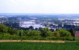
A view of Chanteloup-les-Vignes and the River Seine | ||
| ||
 Chanteloup-les-Vignes | ||
|
Location within Île-de-France region  Chanteloup-les-Vignes | ||
| Coordinates: 48°58′45″N 2°01′55″E / 48.9792°N 2.0319°ECoordinates: 48°58′45″N 2°01′55″E / 48.9792°N 2.0319°E | ||
| Country | France | |
| Region | Île-de-France | |
| Department | Yvelines | |
| Arrondissement | Saint-Germain-en-Laye | |
| Canton | Andrésy | |
| Intercommunality | Deux rives de la Seine | |
| Government | ||
| • Mayor (2001–2008) | Pierre Cardo | |
| Area1 | 3.33 km2 (1.29 sq mi) | |
| Population (2006)2 | 8,980 | |
| • Density | 2,700/km2 (7,000/sq mi) | |
| Time zone | CET (UTC+1) | |
| • Summer (DST) | CEST (UTC+2) | |
| INSEE/Postal code | 78138 / 78570 | |
| Elevation |
38–171 m (125–561 ft) (avg. 20 m or 66 ft) | |
|
1 French Land Register data, which excludes lakes, ponds, glaciers > 1 km² (0.386 sq mi or 247 acres) and river estuaries. 2 Population without double counting: residents of multiple communes (e.g., students and military personnel) only counted once. | ||

Chanteloup-les-Vignes is a commune in the Yvelines department in the Île-de-France in north-central France.
The town was used for a large part of the film La Haine.
Demographic evolution
| Year | 1962 | 1968 | 1975 | 1982 | 1990 | 1999 | 2006 |
|---|---|---|---|---|---|---|---|
| Population | 1777 | 2075 | 4616 | 10297 | 10175 | 9535 | 8924 |
| From the year 1962 on: No double counting—residents of multiple communes (e.g. students and military personnel) are counted only once. | |||||||
See also
References
| Wikimedia Commons has media related to Chanteloup-les-Vignes. |
This article is issued from Wikipedia - version of the 5/26/2015. The text is available under the Creative Commons Attribution/Share Alike but additional terms may apply for the media files.