Septeuil
| Septeuil | |
|---|---|
 Septeuil | |
|
Location within Île-de-France region  Septeuil | |
| Coordinates: 48°53′36″N 1°40′56″E / 48.8933°N 1.6822°ECoordinates: 48°53′36″N 1°40′56″E / 48.8933°N 1.6822°E | |
| Country | France |
| Region | Île-de-France |
| Department | Yvelines |
| Arrondissement | Mantes-la-Jolie |
| Canton | Houdan |
| Intercommunality | Pays houdanais |
| Government | |
| • Mayor (2001–2008) | Yves Gouëbault |
| Area1 | 9.40 km2 (3.63 sq mi) |
| Population (2006)2 | 2,135 |
| • Density | 230/km2 (590/sq mi) |
| Time zone | CET (UTC+1) |
| • Summer (DST) | CEST (UTC+2) |
| INSEE/Postal code | 78591 / 78790 |
| Elevation |
52–165 m (171–541 ft) (avg. 70 m or 230 ft) |
| Website | http://www.mairie-septeuil.fr/ |
|
1 French Land Register data, which excludes lakes, ponds, glaciers > 1 km² (0.386 sq mi or 247 acres) and river estuaries. 2 Population without double counting: residents of multiple communes (e.g., students and military personnel) only counted once. | |
Septeuil is a commune in the Yvelines department in the Île-de-France in north-central France.
River
Septeuil is traversed by a small river, la Flexanville. This waterway flows through eight other communes for a total distance of 11.1 kilometres (6.9 mi). The Flexanville is a tributary of the Vaucouleurs which in turn empties into the Seine.[1]
-
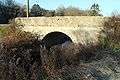
Bridge over la Flexanville
See also
- Communes of the Yvelines department . it's an historic commune with an old church from the 12th century
References
- ↑ Sandre (2010). "La Flexanville (H3074000)". Eaufrance.fr (in French). Office national de l’eau et des milieux aquatiques. Retrieved 3 January 2012.
| Wikimedia Commons has media related to Septeuil. |
This article is issued from Wikipedia - version of the 3/18/2013. The text is available under the Creative Commons Attribution/Share Alike but additional terms may apply for the media files.