Jouars-Pontchartrain
| Jouars-Pontchartrain | ||
|---|---|---|
|
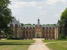
Castle of Ponchartrain | ||
| ||
 Jouars-Pontchartrain | ||
|
Location within Île-de-France region  Jouars-Pontchartrain | ||
| Coordinates: 48°48′14″N 1°54′08″E / 48.8039°N 1.9022°ECoordinates: 48°48′14″N 1°54′08″E / 48.8039°N 1.9022°E | ||
| Country | France | |
| Region | Île-de-France | |
| Department | Yvelines | |
| Arrondissement | Rambouillet | |
| Canton | Montfort-l'Amaury | |
| Intercommunality | Cœur d'Yvelines | |
| Government | ||
| • Mayor (2001–2014) | Marie-Laure Roquelle | |
| Area1 | 9.65 km2 (3.73 sq mi) | |
| Population (2006)2 | 5,129 | |
| • Density | 530/km2 (1,400/sq mi) | |
| Time zone | CET (UTC+1) | |
| • Summer (DST) | CEST (UTC+2) | |
| INSEE/Postal code | 78321 / 78760 | |
| Elevation |
67–171 m (220–561 ft) (avg. 112 m or 367 ft) | |
|
1 French Land Register data, which excludes lakes, ponds, glaciers > 1 km² (0.386 sq mi or 247 acres) and river estuaries. 2 Population without double counting: residents of multiple communes (e.g., students and military personnel) only counted once. | ||

Jouars-Pontchartrain is a commune in the Yvelines department in the Île-de-France region in north-central France. It is approximately 35 kilometres from Paris.
Monuments
- The Château de Pontchartrain built in the 17th century. It was held for many years by the family Phélypeaux.
- St Martin's Church from the 12th century.
- St-Lin's church.
Twin towns
See also
References
| Wikimedia Commons has media related to Jouars-Pontchartrain. |
This article is issued from Wikipedia - version of the 10/7/2015. The text is available under the Creative Commons Attribution/Share Alike but additional terms may apply for the media files.