Cléré-les-Pins
| Cléré-les-Pins | |
|---|---|
|
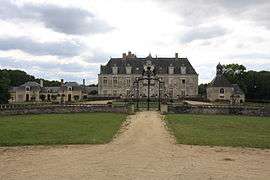
Chateau of Champchevrier | |
 Cléré-les-Pins | |
|
Location within Centre-Val de Loire region  Cléré-les-Pins | |
| Coordinates: 47°25′34″N 0°23′30″E / 47.4261°N 0.3917°ECoordinates: 47°25′34″N 0°23′30″E / 47.4261°N 0.3917°E | |
| Country | France |
| Region | Centre-Val de Loire |
| Department | Indre-et-Loire |
| Arrondissement | Chinon |
| Canton | Langeais |
| Government | |
| • Mayor (2008–2014) | Alain Kuntz |
| Area1 | 35.62 km2 (13.75 sq mi) |
| Population (2009)2 | 1,273 |
| • Density | 36/km2 (93/sq mi) |
| Time zone | CET (UTC+1) |
| • Summer (DST) | CEST (UTC+2) |
| INSEE/Postal code | 37081 / 37340 |
| Elevation | 80–111 m (262–364 ft) |
|
1 French Land Register data, which excludes lakes, ponds, glaciers > 1 km² (0.386 sq mi or 247 acres) and river estuaries. 2 Population without double counting: residents of multiple communes (e.g., students and military personnel) only counted once. | |
Cléré-les-Pins is a commune in the Indre-et-Loire department in central France.
Population
| Historical population | ||
|---|---|---|
| Year | Pop. | ±% |
| 1793 | 1,061 | — |
| 1800 | 1,037 | −2.3% |
| 1806 | 1,032 | −0.5% |
| 1821 | 1,201 | +16.4% |
| 1831 | 1,317 | +9.7% |
| 1836 | 1,236 | −6.2% |
| 1841 | 1,220 | −1.3% |
| 1846 | 1,290 | +5.7% |
| 1851 | 1,330 | +3.1% |
| 1856 | 1,370 | +3.0% |
| 1861 | 1,338 | −2.3% |
| 1866 | 1,323 | −1.1% |
| 1872 | 1,230 | −7.0% |
| 1876 | 1,239 | +0.7% |
| 1881 | 1,213 | −2.1% |
| 1886 | 1,174 | −3.2% |
| 1891 | 1,186 | +1.0% |
| 1896 | 1,179 | −0.6% |
| 1901 | 1,201 | +1.9% |
| 1906 | 1,211 | +0.8% |
| 1911 | 1,208 | −0.2% |
| 1921 | 1,187 | −1.7% |
| 1926 | 1,204 | +1.4% |
| 1931 | 1,139 | −5.4% |
| 1936 | 1,072 | −5.9% |
| 1946 | 1,057 | −1.4% |
| 1954 | 1,068 | +1.0% |
| 1962 | 1,004 | −6.0% |
| 1968 | 909 | −9.5% |
| 1975 | 797 | −12.3% |
| 1982 | 891 | +11.8% |
| 1990 | 1,049 | +17.7% |
| 1999 | 1,166 | +11.2% |
| 2006 | 1,166 | +0.0% |
| 2009 | 1,273 | +9.2% |
See also
References
| Wikimedia Commons has media related to Cléré-les-Pins. |
This article is issued from Wikipedia - version of the 6/8/2014. The text is available under the Creative Commons Attribution/Share Alike but additional terms may apply for the media files.