Chambourg-sur-Indre
| Chambourg-sur-Indre | |
|---|---|
|
Town hall | |
 Chambourg-sur-Indre | |
|
Location within Centre-Val de Loire region  Chambourg-sur-Indre | |
| Coordinates: 47°10′56″N 0°58′05″E / 47.1822°N 0.9681°ECoordinates: 47°10′56″N 0°58′05″E / 47.1822°N 0.9681°E | |
| Country | France |
| Region | Centre-Val de Loire |
| Department | Indre-et-Loire |
| Arrondissement | Loches |
| Canton | Loches |
| Government | |
| • Mayor (2014–2020) | Laurent Couraud |
| Area1 | 28.39 km2 (10.96 sq mi) |
| Population (2012)2 | 1,344 |
| • Density | 47/km2 (120/sq mi) |
| Time zone | CET (UTC+1) |
| • Summer (DST) | CEST (UTC+2) |
| INSEE/Postal code | 37049 / 37310 |
| Elevation | 62–119 m (203–390 ft) |
|
1 French Land Register data, which excludes lakes, ponds, glaciers > 1 km² (0.386 sq mi or 247 acres) and river estuaries. 2 Population without double counting: residents of multiple communes (e.g., students and military personnel) only counted once. | |
Chambourg-sur-Indre is a French commune the department of Indre-et-Loire in region of Centre.
Perhaps already occupied in the Neolithic era, the site was colonized at the time of the Roman Empire; witnessed by many traces of an aqueduct, a Roman villa, a Roman road. Hosting a Viguerie (medieval administrative court) and a medieval fief, Chambourg became a commune in 1789, following an exchange of hamlets hitherto undivided with its neighbor Chédigny. Flooding of the Indre, always to be feared in 2014, has not deterred people from settling permanently in Chambourg on the banks of the river.
Formed as Chambourg-sur-Indre in 1920, the town is one of the few rural areas of Lochois that as not experienced population decline in the 20th century. In 2011, its population was 1,317. Over the last 30 years, agriculture in the community has refocused around large farms specializing in the cultivation of cereals, oil seeds and protein crops. In industry, since 1961, Chambourg-sur-Indre has welcomed a major French company in the field of traffic signs.
Between the Gâtine of Loches plateau, the Loches forest and the Indre valley, Chambourg has in its territory varied wildlife worthy of being partially integrated with multiple national conservation efforts including (ZNIEFF) and (Natura 2000) for the assessment and protection of biodiversity.
Geography
Location and surrounding communities
The town of Chambourg-sur-Indre is located in the southeast quadrant of the Indre-et-Loire department, in the historical region of Touraine. Chambourg-sur-Indre is located at 31.8 kilometres (19.8 mi) southeast of Tours, as the crow flies[1] prefecture of the Indre-et-Loire department is 6.3 kilometres (3.9 mi) north in Loches.[2]
Geology and topology
The main geological formation Chambourg-sur-Indre is Cenomanian sandstone, deposited about 95 million years (Ma) ago by a sea that covered Touraine. Deposits laid on top of this are a yellow Turonian limestone (deposited 90 Ma), then a layer of Senonian chalk (between 89 and 65.5 Ma); the sea receded at the end of this period, which corresponds to the end of Mesozoic ear.[3] In the northwest corner of the commune, a different seas deposited the limestone lake in the middle and the end of the Eocene epoch (37 to 34 Ma), characteristic of the small fertile agricultural region of Champeigne tourangelle.[4] The rest of the plateau is irregularly covered with loess (wind blown sediment) from the Quaternary period,[5] forms an infertile soil called "bournais".[6] The valleys of the Indre and its tributaries, which have cut the base of the limestone plateau during alternating glacial and interglacial periods of the Pleistocene, are covered with recent alluvium, giving the soil a hydromorphous tendency, often with a shallow water table. The slopes between the plateau and the valleys are eroded washed silt or gravel deposits and clay from the Turonian and Senonian strata;[7] this type of soil is called "perruche" (parakeet) in the Loire Valley.[8]
The land area of Chambourg-sur-Indre is 2,839 hectares (on 1 January 2014), the average area of a French commune being 1,510.2 hectare.[INSEE 1][INSEE 2]
The altitude of this area varies between 62 metres (203 ft) and 119 metres (390 ft).[9] The lowest point is on the edge of Indre within the municipal boundary of Azay-sur-Indre and the highest is on the west plateau, bordering Chanceaux-près-Loches and Dolus-le-Sec.[4]
Natural landscapes
Woods and forests are still present in Chambourg-sur-Indre where they still account for about a fifth of the total area of the municipality.[10] They are found in the east, near Saint-Quentin-sur-Indrois and Ferrière-sur-Beaulieu (limit of Loches National Forest), as in the west, where they form a band from commune headquarters to the municipal boundary with Chanceaux-près-Loches. The broad valley of the Indre offers a landscape of meadows, most of which are flooded during flood periods, bordered by groves of poplars to enhance area once covered in grass. The rest of the municipality, namely non-forested parts of the plateau adjoining the Indre Valley by wooded slopes, dedicated to agriculture, of an average fertility, except for the extreme north-western tip of the town, established in Champeigne "a locality there besides that name", with much more favorable agronomic characteristics.[10]
Waterways

The municipality of Chambourg-sur-Indre is crossed from south-southeast to north-north-east by the Indre river which cut into the plateau a broad valley about 500 metres (1,600 ft) wide. At the bottom of this valley, and due to its shallow slope, the Indre navigates many bends and oxbow lakes, even forming downstream of the urban core Chambourg-sur-Indre, two separate lakes enclosing an island. Indre is fed with a half-dozen streams originating on the plateau to the left side or in the forest of Loches for the right bank. Their courses are usually perpendicular to that of the Indre, including at their confluence.[11] Floods of the Indre are of the flood plain type,[Note 1] threatening areas of the town built closer to the river.[12]
The Indre is mentioned for the first time by Gregory of Tours in the 6th century under the name fluvium Angerem". This name is often attributed to a change in the Frankish language anger (prairie grass) from the root ang- or 'angr-.[13]
Climate
The geographical location of Chambourg-sur-Indre gives it a temperate ocean climate;[14] The coast at Rochelle is 200 kilometres (120 mi) away "as the crow flies". This type of climate, subject to prevailing westerly flow over the year is characterized by mild temperatures, the average monthly minimum is never below freezing, even in winter, while in summer it is common to have a heatwave for a few days. No month is truly dry, average monthly rainfall is always greater than 40 millimetres (1.6 in).
Below are the meteorological data for Tours Station (33.2 kilometres (20.6 mi) north-northwest of Chambourg-sur-Indre).
| Climate data for Tours Weather Station | |||||||||||||
|---|---|---|---|---|---|---|---|---|---|---|---|---|---|
| Month | Jan | Feb | Mar | Apr | May | Jun | Jul | Aug | Sep | Oct | Nov | Dec | Year |
| Average high °F (°C) | 45.1 (7.3) |
47.3 (8.5) |
54.1 (12.3) |
59.4 (15.2) |
66.4 (19.1) |
73 (22.8) |
77.9 (25.5) |
77.9 (25.5) |
71.2 (21.8) |
62.2 (16.8) |
33.6 (0.9) |
45.5 (7.5) |
61 (16.1) |
| Daily mean °F (°C) | 40.5 (4.7) |
41.4 (5.2) |
46.6 (8.1) |
50.7 (10.4) |
57.6 (14.2) |
63.5 (17.5) |
67.6 (19.8) |
67.3 (19.6) |
61.7 (16.5) |
54 (12.2) |
46 (7.8) |
41 (5.0) |
53.2 (11.8) |
| Average low °F (°C) | 35.6 (2.0) |
35.4 (1.9) |
39 (3.9) |
42.1 (5.6) |
48.6 (9.2) |
53.8 (12.1) |
57.2 (14.0) |
56.8 (13.8) |
52 (11.1) |
47.5 (8.6) |
40.3 (4.6) |
36.5 (2.5) |
45.5 (7.5) |
| Average precipitation inches (mm) | 2.61 (66.3) |
2.201 (55.9) |
1.976 (50.2) |
2.201 (55.9) |
2.453 (62.3) |
1.815 (46.1) |
2.094 (53.2) |
1.677 (42.6) |
2.098 (53.3) |
2.795 (71.0) |
2.744 (69.7) |
2.803 (71.2) |
27.398 (695.9) |
| Mean monthly sunshine hours | 69.2 | 92.0 | 142.1 | 180.4 | 202.5 | 228.2 | 249.1 | 239.0 | 186.0 | 123.3 | 79.5 | 57.1 | 1,848 |
| Source: MétéoCentre : Tours[15] | |||||||||||||
Around these average values, we sometimes observe substantial differences, having an unsurpassed record 2012; thus the 10 August 2003, during the European heat wave, the maximum temperature was observed 39.8 °C (103.6 °F); the lowest temperature ever recorded in Tours is −18.5 °C (−1.3 °F) on 29 December 1964; a record rainfall of 958 millimetres (37.7 in) was recorded in 1999.[15]
Comparing averages from the thirty stations in Tours[15](given below) appears to highlight a certain level rise of temperatures (minimum, average and maximum) on the three reference periods; the sunshine and precipitation parameters do not change noticeably.[Note 2]
| 1961-1990 | 1971-2000 | 1981-2010 | |
|---|---|---|---|
| mean minimum temperature | 6.9 °C (44.4 °F) | 7.1 °C (44.8 °F) | 7.5 °C (45.5 °F) |
| mean temperature | 11.2 °C (52.2 °F) | 11.4 °C (52.5 °F) | 11.8 °C (53.2 °F) |
| mean maximum temperature | 15.4 °C (59.7 °F) | 15.7 °C (60.3 °F) | 16.1 °C (61.0 °F) |
| hours of sunlight | 1815.6 | 1799.0 | 1848.0 |
| precipitation | 678.9 millimetres (26.73 in) | 704.0 millimetres (27.72 in) | 695.9 millimetres (27.40 in) |
Communication and transport
Air travel
A 53 minutes road trip from Chambourg,[16] the Tours Val de Loire Airport in 2014 offered regular services to Ajaccio, Figari, Toulouse, Dublin, London, Marrakech and Porto; other destinations, seasonal or charter, are available.[17]
Rail travel
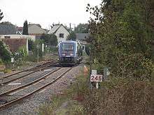
The people of Chambourg can go to Loches and Tours by train, using the TER Centre line Tours-Loches, accessible by train from the Chambourg train station or by bus, which stops in the center of town according to schedules.[18] Chambourg-sur-Indre offers a parking area for the carpooling, equipped with a charging point for electric vehicles.[Site 1]
Roads
The main road through Chambourg-sur-Indre is the D943 (formerly N143) that crosses the plateau west of the Indre almost right on the 28 kilometres (17 mi) marker separating Tours from Chambourg-sur-Indre; it then descends into the valley of the Indre to join Loches 12 kilometres (7.5 mi) from Chambourg-sur-Indre; between Cormery and Chambourg-sur-Indre, is joined by D17 after the Indre valley on the left bank and directly serves the center of the town before joining the D943 at the southern end of the town center. It is also possible to go from Loches Chambourg using the D25 along the right bank of the Indre between the Island Thimée (Chambourg) and Corbery (Loches).
City planning
City changes
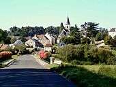
The urban center of Chambourg-sur-Indre is grouped around the pole formed by the church and the town hall from the intersection of the D94 (north-east south-east) and D17 (northwest southeast). The site overlooks by 10 metres (33 ft) the left side of the Indre Valley flowing northeast, is immune to flooding.[19] The town has expanded since 1980 as subdivisions are built along new roads, west and east of the town in recent projects, being established more directly in the bottom of the valley of the Indre. To the west of the town is business district. Once having crossed the series of three bridges that cross the D94 to the Indre valley towards the northeast and Chédigny we find Thimée Island, an important hamlet also benefiting from new construction, with the town center hanging somehow on the right bank of the Indre.[Site 2]
Several other villages, mostly located at the foot of the hill on the right bank of the Indre, are experiencing the same level of development. Part of the area situated on the plateau on the right bank of the Indre is much less populated, with the exception of "one-road town" built not far from the castle Marray on a promontory surrounded by the valleys of two parallel streams, tributaries of the left bank of the Indre.[Site 2]
Housing
The table below presents a comparison of housing in Chambourg-sur-Indre and throughout the Indre-et-Loire in 2011, through some indicators:[INSEE 3][INSEE 4]
| Chambourg-sur-Indre | Indre-et-Loire | |
|---|---|---|
| Portion of Primary Residences (in %) | 87.0 | 88.4 |
| Portion of vacant residences (in %) | 5.6 | 7.1 |
| Share of homeowners (in %) | 76.7 | 58.6 |
Chambourg-sur-Indre is typically characterized by a proportion of households owning their home being very much higher (+ 31%) than the county average; rental housing represents only 21.9% of primary residences. In 2011, 59.5% of households lived in the town for more than 10 years. Between 1991 and 2008, 101 main residences were built, 97 houses and 4 apartment units, an increase of 19.7%.[INSEE 3]
Second homes account for 7.4% of homes in Chambourg-sur-Indre, a value well above the average of the Indre-et-Loire, which stood at 4.4%.[INSEE 3][INSEE 4]
Recent and future improvements
In 2013, the municipality undertook the burial of electrical networks in many of its streets.[20] On November 24, 2014, a new first response center of firefighters was dedicated.[Site 3]
At its meetings of May and June 2014, the City Council discussed several interesting development projects for urbanism and habitat, such as the construction of a car park and the redevelopment of a Street Chambourg-sur-Indre, preceded by burying electricity and telecommunications networks.[Site 4]
Major natural hazards
On 28 April 2005, the prefecture of Indre-et-Loire adopted a plan to prevent flooding for all municipalities in the Indre department, which includes Chambourg-sur-Indre; accordingly, the land located in the Chambourg extreme flood hazard zone are unsuitable for.[21] A prefectural order dated 29 April 2011 specifies the nature of natural hazards to which Chambourg-sur-Indre is subject;[22] they are of two types: flooding due to an overflow of the Indre or flooding from storm water runoff. The same document details the decrees of acknowledgment of natural disasters made between 1983 and 2011 for the municipality of Chambourg-sur-Indre, two decrees for floods and mudslides (1983 and 1985), two decrees for landslides following a drought (1993 and 2005) and one decree for floods, mudslides and landslides (1999). This paper also indicates that Chambourg-sur-Indre is located in a low risk earthquake zone: level 2 on a scale of 1-5.
The risk of landslides after drought is due to the successive phases of shrinking and swelling clays could undermine the foundations of buildings.[23] All of the plateau of Chambourg-sur-Indre, on both sides of the Indre, is subject to a "medium" or "strong" rating for this risk, while in the valley of the Indre, this risk is considered "lower" or "a priori", according to the scale defined by the (BRGM).[24]
Name origin
The place name Chambourg appears for the first time in the founding charter of the abbey of Cormery from 791 as Condita Cambortensis. In the tenth century, villa Cambort was used, Chamborc' ' in the ecclesiastical register of Tours from 1290 or Chambourt in a cartulary of chartreuse du Liget in 1304.[25]
As shown in the older forms, it is kind Gallic name Cambo-ritu, based on two Celtic roots cambo- (curve, bend) and rito, ritu (ford), hence the overall sense of "stepping into the curve" or "ford of the meander".[26][27][25] The etymology continued to change to, among others, Château de Chambord or Chambors (Oise).[28] Indeed, the element ritu- preceded by -o-, has led to a regular termination -or- written variously as -ort (for example Niort, Jort), -ors or -ord. Chambort was reinterpreted Cham-bourg (Cham-town) by analogy with the term bourg (village) in the Middle Ages.
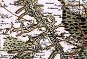
The current spelling appears in the Cassini map; the final name of the town, Chambourg-sur-Indre was fixed by the order of 23 August 1920, the complementary suffix 'sur-Indre' avoiding possible confusion elsewhere with the same name.[Site 5]
The names l'Île Thimée (Thimée Island) and l'Île Auger (Auger Island) refers to a time when these place names, were in the area of the Indre; this is no longer the case in modern times. According to written sources, both spellings "isle" (old spelling) or "île" (modern spelling) are used indiscriminately. In this article, the modern spelling is used.
History
Prehistory and early history
The oldest traces of human presence on the site Chambourg-sur-Indre manifest themselves in the form of a racloir (scraper), a typical tool of Mousterian,[29] found by chance during of a survey of soil in the forest of Loches; Neolithic tools were also found.[30] We presume the existence of a Neolithic settlement at a place called "Chatres". The possible origin of the place name in the Gallo-Roman CASTRU (from the Latin castrum "fortified camp") and the layout "limited to a promontory east through the valley of the Indre and north and south by the courts of two of its tributaries streams" (translated) suggest the existence of a promontory fort; however, no excavation has yet verified the validity of this hypothesis.[30]
Antiquity

The Gallo-Roman site at Cornillé, on the left bank of the Indre 3.5 kilometres (2.2 mi) upstream of the town contains reticulated walls (opus reticulatum) that were still visible at the beginning of the nineteenth century, and a hypocaust (underfloor heating) and the remains of an aqueduct; in 2014 the only remaining portions of walls in basements.[30] This site was perhaps that of a mansio[31] (way station). On the right bank of the Indre, between Corbery (village of Loches) and Auger Island on Chambourg-sur-Indre, D25 follows almost exactly an ancient road[30] which continued in antiquity to Azay-sur-Indre beyond the Thimée Island without leaving the right bank of the Indre.[31] Coins bearing the image of the emperors Nero, who reigned from 54 to 68, and Septimius Severus (193-211) were discovered in the town, on the site of a domus[32] It should be noted that there is a medieval bridge on Auger Island nicknamed "Roman bridge" on many documents (maps [Institut géographique national|National Geographic Institute (IGN)] ] for example) and on the signs.
Middle ages
Chambourg was promoted to the rank of Viguerie in the ninth century;[10] while these honors were often temporary, Chambourg Viguerie, whose existence is supported for more than a century and a half, was an exception, or at least a rarity.[33] At the end of the tenth century early eleventh century, the Count of Anjou and the house of Blois fought over Touraine, snatching and taking each other's territories. No document seems to mention such problems for Chambourg. In the Middle Ages, Chambourg was a fief, subordinate to Castle Bray,[34] which was named at that time, Reignac-sur-Indre in the thirteenth to fifteenth centuries.[35]
From modern day to the Empire
In the seventeenth century, Chambourg was one of eighteen priories subject to the Benedictine Abbey of Cormery.[36] However, the monks of the Beaulieu-lès-Loches Abbey (also Benedictine) collected taxes on
fisheries in Indre, Chambourg to Azay-le-Brûlé (today Azay-sur-Indre) in the amount of 60 pounds.[37]
Also, in the seventeenth century, several titled aristocrats arrived in the area of Chambourg.[38][Site 5] The forest of Loches was considered a rich source of food for it contains game, chestnuts, honey, the firewood and lumber that provides for heating and buioling,[39] and any offense committed against the forest was severely punished; between 1750 and 1790, several residents of the Auger Island and other villages in Chambourg were arrested for illegal logging of 60 oaks in the massive forest of Loches, and of other timber theft.[40]
Until the French Revolution, some hamlets close to the boundary between the parishes of St. Martin and St. Chambourg Michel Chédigny (the parish gathering the inhabitants of the left bank of the Indrois), which hamlets were called "turning and twisting" (translated), that is to say, they were subject to one or the other parish, alternating annually, had at its center, a complex system of financial compensation between the parishes concerned.[41] This ended with the creation of the commune on December 14, 1789 and the delimitation of their territories; these hamlets were then attached permanently to Chambourg, or Chédigny.
Modern day
The creation of the railway line connecting Tours Châteauroux, opened between Joué-lès-Tours and Loches in 1879 with the creation of a stop in Chambourg in 1879[42] can be considered a milestone for the town ; at the time when the rural exodus began to be felt in the villages, it limited the impact to Chambourg allowing the inhabitants of the town to continue to live there, or even to settle in town while working Tours, but especially Loches.[30] This demographic dynamic was reinforced by the installation at the beginning of the 20th century, businesses related to agriculture, mills on the Indre and grain storage silos, the latter taking advantage of the proximity of rail service. These companies gradually disappeared in the second half of the 20th century but were replaced by others, such as a large road sign factory located in Chambourg since 1961 which has more than one hundred employees.[30]
Forty-eight Chambourgeois died in combat during World War I,[43] or about one out of 20.
On June 19, 1940, when German troops were reported in the eastern department, the French army was trying to slow their advance by blowing up the bridges over the Indre, including Chambourg.[44] Between June 22, 1940 and 28 February 1943, the demarcation line ran north-south in the town of Le Château-le-Sec, bordering Chambourg-sur-Indre on the west: Chambourg-sur-Indre was in zone libre (unoccupied territory), but only a few kilometers from the line; the municipality was rejoined on 28 February 1943 to the prefecture of Indre.[45] As early as June 1940, the prefect of Indre replaced the elected mayor by a special delegation of four members who served until October 1944.[46] In the last decade of August 1944, German troops gradually withdrew to the north and east of the department after Loches was recaptured they had to leave for a few days. Their headquarters was temporarily set up in St. Valentin, a hamlet of Chambourg near the municipal boundary with Loches.[47]
Policy and administration
Administration
Chambourg-sur-Indre is part of Canton of Loches, which includes twenty towns around Loches, the chief town of the district. It is attached to the arrondissements (district) of Loches and the third electoral district of the Indre-et-Loire, whose MP is Marisol Touraine, Socialist Party since 2012.[48]
Political tendencies and results
The results of the last two presidential elections show an electorate anchored to the left, in a town that has elected a mayor belonging to the French Communist Party between 1995 and 2014; the results of regional elections and the last two parliamentary elections confirm this trend. The incumbent mayor did not seek a fifth term in municipal elections in 2014 which the voting, similar to the municipal elections in 2008, does not bring out a decisive political orientation. The European election results do not lend themselves to analysis with a relatively low participation and voting in one round which promotes the dispersion of votes but for the first time, the electorate middle class nominated National Front candidates at the top of their votes.[Note 2]
Latest presidential elections
In the second round of the presidential elections of 2007, Nicolas Sarkozy, Union for a Popular Movement was elected, obtaining 48.33% of the vote Segolene Royal, Socialist Party, 51.67% of the vote; turnout was 86.56%.[49] In the second round of the presidential elections of 2012, François Hollande, Socialist Party was elected, receiving 52.57% of the vote Nicolas Sarkozy, Union for a Popular Movement, 47.43% of the vote; turnout was 82.57%.[50]
Latest municipal elections

The population at the last census being between 500 and 1499 inhabitants, the number of council members is 15.[51] In the municipal elections of 2008, 15 councilors were elected in the first round; turnout was 66.13%.[52] In the municipal elections of 2014, 15 councilors were elected in the first round, with a participation rate of 56.85%; the only list presented obtained three seats on the community council.[53]
List of mayors
| From | To | Name | Party | Notes |
|---|---|---|---|---|
| 1802 | 1826 | Pierre Cellier | ||
| 1826 | 1834 | Perfus | ||
| 1835 | 1843 | Pierre Cellier | ||
| 1843 | Aug 1847 | Descombes | ||
| Aug 1847 | Dec 1847 | Robellandes | [Note 4] | |
| Jan 1848 | Nov 1848 | Douard | [Note 5] | |
| Nov 1848 | Dec 1869 | Charles Deplais | ||
| Jan 1870 | Aug 1870 | Simon Dubois | ||
| Sep 1870 | Sep 1876 | Louis Cellier | ||
| Oct 1876 | Apr 1883 | Lucien Monnessier | [Note 6] | |
| Apr 1883 | Apr 1883 | Jean Arrault | [Note 7] | |
| May 1883 | Dec 1886 | Étienne Gripouilleau | [Note 8] | |
| Dec 1886 | Dec 1886 | Jean Arrault | [Note 9] | |
| Jan 1887 | Jan 1887 | Louis Girard | [Note 10] | |
| Feb 1887 | Aug 1899 | Louis Crépin | ||
| Aug 1899 | May 1904 | Joseph Perreau | ||
| May 1904 | May 1908 | Couchelay Deroche | ||
| Jun 1908 | Apr 1933 | Émile Douard | [Note 11] | |
| May 1933 | Jun 1933 | Léon Marcadier | [Note 12] | |
| May 1933 | Aug 1940 | Léon Marcadier | ||
| Aug 1940 | Oct 1944 | Identité=no mayor | a special delegation held the office | |
| Oct 1944 | 1952 ? | Marcel Viraud | ||
| Mar 1995 | Mar 2014 | Guy Moreau | PCF | |
| 29 Mar 2014 | Laurent Couraud | [55] |
Judicial and administrative bodies
Until late 2009, the people of Chambourg-sur-Indre were within the jurisdiction of the Loches District Court. Since the judicial redistricting on 1 January 2010, Chambourg-sur-Indre was placed in the jurisdiction of the District Court of Tours, except for which is responsible for the entire department. All jurisdictions in Chambourg-sur-Indre are thus grouped in Tours, with the exception of administrative court based in Orleans.[56]
The town is located in the area of gendarmerie of proximity brigade of Loches.[57]
Intercommunal relations
Chambourg-sur-Indre is part of Association for Development of Loches Communes since its inception on December 31, 1995. which includes twenty municipalities with a population of 21,550 of which 6455 inhabit Loches as of 2011.
The inter-community energy union of Indre-et-Loire (SIEIL) provides control and coordination of all dealers operating in the Indre-et-Loire in the field of distribution of gas and electricity; it also focuses on strengthening electricity resourcing and distribution. Founded in 1937, it has gradually evolved in the context of opening energy markets to competition.[58] By prefectural decree dated April 23, 2008, all municipalities in Indre-et-Loire, Tours excepted, each adhere to SIEIL.
A single-purpose intercommunal union (SIVU), to which Chambourg-sur-Indre belongs, as well as 48 other municipalities in the Lochois, supports the transport of high school students between their respective municipalities and public and private secondary schools, open in the scope of this SIVU skills. It is the municipal association of school transport Lochois headquartered at Ferrière-sur-Beaulieu and operates in agreement with a professional carrier.[59]
Environmental policy
Communauté de communes Loches Développement (Organization of Communes of Loches for Development) administers a common environmental policy throughout its territory.
Water and sanitation
Since 1 January 2012, the Régie eau potable et assainissement (Department of drinking water and sanitation) supports the organization of the drinking water distribution and maintenance of sewer systems.[L.Dév. 1] On December 31, 2012, the drinking water was supplied to 634 subscribers. This water is taken from three wells exploiting the water Seno-Turonian[60] in the area of the municipality of Reignac-sur-Indre. After removal of iron and UV treatment, the water is distributed or sent to a storage tank in Chambourg-sur-Indre.[L.Dév. 2][61]
For 265 subscribers in Chambourg-sur-Indre (as of December 31, 2012), wastewater treatment is provided by:[L.Dév. 3]
- A wastewater treatment plant using artificial wetland, with a capacity of 600 EH (population equivalent) for the town;
- Two treatment plants (STEP) equipped with a reed bed filter device; with a capacity of 200 and 110 EH, they respectively serve the hamlets of Thimée Island and Upper Luain;
- A septic tank (FSTE) with a sand filter with a capacity of 40 EH for tiny Luain.
Household waste
There is a weekly garbage collection and household waste at each home. Glass containers and newspapers-magazines are located on two sites in the municipality. Collection of bulky items is performed once a year door-to-door. The people of Chambourg-sur-Indre, who are likely to have a garden, can also get bins for composting their garden waste. Finally, they have access to waste disposal of Chanceaux-près-Loches or Tauxigny, at a distance, respectively, of 6.5 kilometres (4.0 mi) and 12 kilometres (7.5 mi).[L.Dév. 4]
Local finance
The table below shows some elements of the local finances of Chambourg-sur-Indre, over a period of nine years:[62]
| Years | Accounting income | Requirement ( financing of investments |
Self Financing Capacity (CAF) | |||
|---|---|---|---|---|---|---|
| Chambourg | Average | Chambourg | Average | Chambourg | Average | |
| 2005 | 604 | 140 | |
|
152 | 142 |
| 2006 | - 318 | 148 | |
|
133 | 151 |
| 2007 | 160 | 148 | |
|
160 | 152 |
| 2008 | 123 | 147 | |
|
123 | 151 |
| 2009 | 120 | 142 | |
|
124 | 147 |
| 2010 | 94 | 143 | |
|
107 | 150 |
| 2011 | 108 | 160 | |
|
121 | 168 |
| 2012 | 148 | 160 | |
|
161 | 168 |
| 2013 | 101 | 148 | |
|
114 | 156 |
Some general trends, always comparing Chambourg-sur-Indre with the average of its group (municipalities with 500-2000 inhabitants belonging to a tax-group), are released for consideration by these data.[Note 2]
The year 2006 is the only year among those observed where Chambourg-sur-Indre showed a negative accounting income;[Note 13] all other years have seen a positive result even if, since 2008, it is even very slightly below average. The change in the municipalities ability to finance investment shows no clear trend or issues with sustainability.[Note 14] Cash flow,[Note 15][63] like the accounting profit was less than the average of the comparable group since 2008.
Population and society
Demographics[Note 16]
The people of Chambourg-sur-Indre are called 'Chambourgeois'.
In 1687, the parish registers indicated that Chambourg had 187 feu fiscal (tax allocation units), then 208 units in 1789, the last known value before the first census in population.[10]
In 2011, the municipality had 1317 inhabitants. The changing number of inhabitants is known throughout the population census carried out in the town since 1793. From the twenty-first century, the actual census of municipalities with fewer than 10,000 inhabitants are held every five years, in contrast to other cities that have a survey every year.[Note 17][Note 18]
| Historical population | ||
|---|---|---|
| Year | Pop. | ±% |
| 1793 | 689 | — |
| 1800 | 804 | +16.7% |
| 1806 | 861 | +7.1% |
| 1821 | 853 | −0.9% |
| 1831 | 969 | +13.6% |
| 1836 | 966 | −0.3% |
| 1841 | 1,011 | +4.7% |
| 1846 | 1,049 | +3.8% |
| 1851 | 1,069 | +1.9% |
| 1856 | 1,075 | +0.6% |
| 1861 | 1,056 | −1.8% |
| 1866 | 1,034 | −2.1% |
| 1872 | 990 | −4.3% |
| 1876 | 1,046 | +5.7% |
| 1881 | 1,034 | −1.1% |
| 1886 | 1,046 | +1.2% |
| 1891 | 1,006 | −3.8% |
| 1896 | 1,015 | +0.9% |
| 1901 | 1,027 | +1.2% |
| 1906 | 947 | −7.8% |
| 1911 | 945 | −0.2% |
| 1921 | 934 | −1.2% |
| 1926 | 881 | −5.7% |
| 1931 | 890 | +1.0% |
| 1936 | 866 | −2.7% |
| 1946 | 851 | −1.7% |
| 1954 | 881 | +3.5% |
| 1962 | 925 | +5.0% |
| 1968 | 883 | −4.5% |
| 1975 | 779 | −11.8% |
| 1982 | 857 | +10.0% |
| 1990 | 1,080 | +26.0% |
| 1999 | 1,194 | +10.6% |
| 2006 | 1,272 | +6.5% |
| 2009 | 1,287 | +1.2% |
| 2012 | 1,344 | +4.4% |
In contrast to many rural communities, Chambourg-sur-Indre has not experienced a mass exodus during the 20th century; its population has nearly doubled since the French Revolution and increased by nearly 70% between 1975 and 2011, an average gain of 15 inhabitants per year over this period. Examination of the pyramid shows a real lack of population in the age group of 15 29 years, men and women, compared to the county average, while the portion 45–59 years is overrepresented.
Demographic change is due, during the period 1982 - 2010, to both natural growth at net migration, both positive; However, if during the decade 1982 -1990 the net migration accounts for the largest share in the increase in population in the first decade of the 21st century, the increase in population is mainly due to natural increase, as shown by the data in the table below.[INSEE 5][Note 19]
| 1982 - 1990 | 1990 - 1999 | 1999 - 2010 | |
|---|---|---|---|
| Annual rate of population change | + 2,9 | + 1,1 | + 0,7 |
| Natural growth | + 0,3 | + 0,2 | + 0,4 |
| Net immigration | + 2,6 | + 0,9 | + 0,2 |
Education
The town of Chambourg-sur-Indre is part of Orleans-Tours School District. This district is part of the Zone B for its school vacation calendar.
In 2014, the town has, in the Jean Moulin school group, a pre-school and an elementary school with 5 classes and 109 students for the 2013-2014 school year;[64] secondary schools are close to Loches, with two colleges, one public, the other private,[65] and three high schools, two of which are general education schools, one public and one private, and one technical high school.[66]
School children in pre-school and elementary school have a cafeteria in Chambourg-sur-Indre. High school students and students enrolled in Loches have access to transportation allowing them to go to their secondary schools.
Institutions of higher education are located in Tours or in the immediate periphery. Among them, the François Rabelais University offers, in école polytechnique de l'université de Tours and two polytechnic institutes having on forty research laboratories, seven departments for teaching and research; the Graduate School of Business Management of Tours-Poitiers offers at its two sites training baccalaureate+3 or baccalaureate+5; the Brassart school of Tours specializes in graphic arts.[67] In agriculture, the Agricultural High School of Tour Fondettes prepares students to graduate with a senior technician certificate (BTS, Bac + 2).[68]
Cultural events and festivities
Every year in Chambourg-sur-Indre, on the third Sunday of July, the traditional festival "Chambourg beside the Water" is celebrated with dining, entertainment, concerts and fireworks. The event held in 2013 its forty-ninth birthday.[69]
Cultural facilities, social and sporting
A multipurpose room is available in the town,[Site 6] located in a former tile manufactory constructed in 1862. Under the auspices of the General Council of Indre-et-Loire, within the network of the "Department Libraries and Books of Touraine" Chambourg-sur-Indre provides its residents a library[70] with a digital public space.
A recreation area kitchen, a sports field, a tennis court and a bowling green can also be used in Chambourg-sur-Indre.
Associations
Twenty-five associations are available in the town of Chambourg-sur-Indre, seventeen in the field of cultural action, four in the area of social action and five in sport.[71]
Health and emergency services
There is a medical office in Chambourg-sur-Indre; it provides the services of a general pracitioner, a physiotherapist and a nurse.[Site 7] The nearest hospital is the hospital Rives de Loches Indre.[72]
The closest fire and rescue center is in Chambourg-sur-Indre.
Media
The regional newspaper La Nouvelle République du Centre-Ouest in its Indre-et-Loire, Touraine East edition devotes a few pages to the news of the Township of Loches. La Renaissance lochoise, l'hebdomadaire de la Touraine du Sud[73] is a weekly local information sheet on townships in southern Touraine.
In the field of audiovisual media, both television channels of digital terrestrial television are available to all residents of Chambourg-sur-Indre and relay local information on France 3 Centre and fr:TV Tours Val de Loire. Among the numerous radio stations available include fr:France Bleu Touraine and Graffic,[74] based in Loches, is especially dedicated to the music and local information in an area from Tours to Poitiers and Châteauroux.
Telecommunications
In 2014, the entire fixed network deployed in Chambourg-sur-Indre gives access to high speed internet via G.992.5 (ADSL 2+).[75]
Economy
The table below shows the number of companies operating in Chambourg-sur-Indre according to their industry:[INSEE 6]
| Number of institutions involved | |
|---|---|
| TOTAL | 97 |
| Agriculture | 17 |
| Industry | 8 |
| Construction | 17 |
| Trade, transport and other services | 45 |
| Public administration, education, health, and social action | 10 |
Of the 97 companies listed in Chambourg-sur-Indre on December 31, 2011, 79 had no employees, 15 had between 1 and 9 employees, 2 have a staff of between 10 and 19 employees; the latter alone accounts for 105 of 169 jobs available in the town.[INSEE 6]
In 2012 and 2013, nine companies were created Chambourg-sur-Indre, including eight in the area of trade, transport and other services and one in public administration, education, health, and social action.[INSEE 7][INSEE 8]
Businesses and shops
Agriculture
The table below shows the main characteristics of farms surrounding Chambourg-sur-Indre, observed over a period of 22 years:[76]
| 1988 | 2000 | 2010 | |
|---|---|---|---|
| Number of farms | 37 | 19 | 13 |
| Equivalent annual work units | 35 | 14 | 10 |
| Useful Agricultural Area (UAA) (ha) | 1,477 | 1,173 | 1,105 |
| Livestock (heads) | 479 | 188 | 34 |
| Arable land (ha) | 1,311 | 1,149 | 1,098 |
| Average size of a farm (ha) | 39.9 | 61.7 | 85.0 |
Industry
The company Sécurité et Signalisation Nouvelle (New Safety and Signals) (SES), a subsidiary of Colas Group after its restructuring in 2011. It specializes in road signs (panel manufacturing and light frames), employing on its site in Chambourg in late 2013, a hundred people.[77] The company, founded in 1957, moved to Chambourg-sur-Indre in 1961 on the site of an old shoe factory.[10][78]
Tourist trade
On December 31, 2012, the commune of Chambourg-sur-Indre had no hotel or camping on its territory.[INSEE 9] In 2014, the proposed Chambourg-sur-Indre tourist accommodations are spread over four bed and breakfasts and (or) home stays.[79][Site 8]
Revenue and taxation
In 2011, the taxable income by household in France was 32642 Euro, placing Chambourg-sur-Indre in 11,319 rank among 31,886 communities with more than 49 households in mainland France.[INSEE 10]
Indicators of income tax from Chambourg-sur-Indre and throughout the Indre-et-Loire in 2011 were below average:[INSEE 11][INSEE 12]
| Chambourg | Indre-et-Loire | Fluctuation | |
|---|---|---|---|
| Reported net income per household (in €) | 24,869 | 24,480 | + 1,6 % |
| Share of taxable households taxed across all taxable households (in %) | 61.9 | 58.3 | + 6.1% |
The average income per household is slightly higher than the county average, the proportion of taxable households is also higher.[Note 2]
Jobs
The two tables below show the key figures of employment for Chambourg-sur-Indre and how they have changed over the last six years:[INSEE 13][INSEE 14]
| Chambourg 2011 | Chambourg 2006 | |
|---|---|---|
| Population 15 to 64 years | 817 | 812 |
| Active Job Seekers (%) | 75.6 | 75.8 |
| of which : | ||
| Active employment (%) | 68.5 | 71.2 |
| Unemployed (%) | 7.0 | 4.6 |
| Chambourg 2011 | Chambourg 2006 | |
|---|---|---|
| Number of jobs in the area | 246 | 247 |
| Concentration indicator of employment | 43.0 | 42.2 |
Over six years, the workforce of Chambourg-sur-Indre remained stable, but the employment rate of the population is down slightly by 3 points. Unemployment has risen sharply. The number of jobs in the area remained stable, the number of active as well; the concentration indicator of employment is keeping an almost constant level (about 43 employed out of 100 active).[Note 2]
In 2011, active job seekers living in Chambourg-sur-Indre working mainly in a different department (77.7%), more than three quarters. There are only 15.9% working onsite and 6.3% outside the department.[INSEE 15]
Local culture and heritage
Places and monuments
The gothic bridge of Auger Island, built in the 15th century, has been declared a monument historique (historical monument), registered since October 24, 1927.[80] This bridge connected the two banks of the Indre near an ancient ford which is assumed to be Roman and has a, perhaps unfair, nickname of "Roman bridge" and is even mentioned as such in various print and on signs. The Napoleonic map reports this bridge as the 'Old Bridge', without reference to its date of construction.[81] There now remains only two arches and four bases.[30]
The church of Chambourg-sur-Indre is one of 3,700 religious buildings in France dedicated to St. Martin.[82] Built in the 11th or 12th centuries, it underwent a major restoration around 1870, but the Romanesque door that opens into the south side of the nave was not altered.
The Grand Marray was the site of a villa mentioned in the cartulary of Cormery in 861[30] and built in the dependent fief of Reignac-sur-Indre, at the time a property of the family Menou[34] which also owned the castle Genillé until the French Revolution.[83] A château was built in the 19th century.
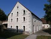
The Chavigny mansion, in the 17th century belonged to a Marshal General of the King's camps and armies. King Louis XI sometimes stayed there.[Note 20] The oldest part of this house, dating from the 15th century, is flanked by a rectangular turret.[30]
- Places and monuments of Chambourg-sur-Indre.
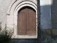
The Romanesque door of the church of St. Martin. 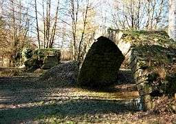
The eastern arch of the bridge of the Auger Island.
Natural heritage
National zones of ecological interest, fauna and flora
Having as its goal an inventory of plant and animal species in the area, the creation of Zone naturelle d'intérêt écologique, faunistique et floristique (ZNIEFF) is accompanied by no measure of regulatory protection. The municipality of Chambourg-sur-Indre is integrated to the tip of its territory, as far as Chédigny, Saint-Quentin-sur-Indrois and Ferrière-sur-Beaulieu, the ZNIEFF of Massif forestier de Loches (Loches Forest): This ZNIEFF contains 5066 hectares and extends over 10 communes. Considered one of the richest wooded areas of Indre-et-Loire, the forest of Loches hosts several remarkable species. Some of them are protected at national or regional level, such as the lesser horseshoe bat, a species of bat that hunts on the edge of this forest, the stag beetle (Lucanus cervus), whose larvae live in the trunks of dead trees on which they feed, or the adder's-tongue (Ophioglossum vulgatum), a rare fern.[84]
Natura 2000 network
Sance 2006, about a fifth of Chambourg-sur-Indre, to the west, next to the communes of Azay-sur-Indre and Dolus-le-Sec has been included in the Natura 2000 nework of nature protection areas. The Special Protection Area (ZPS) thus formed, called site Natura 2000 Champeigne, is found on the ZNIEFF of plateau Champeigne between Bléré and Loches; it aims at the preservation of bird species encountered in its territory, as the little bustard (Tetrax Tetrax),[L.Dév. 5] through appropriate agoenvironmental measures imposed on farms,[85] in accordance with Birds Directive of 30 November 2009 enacted by the European Union.
Other natural heritage items
The Eurasian beaver, which is reclaiming streams in Touraine after its reintroduction in the Loire about thirty years ago, and the European otter (Lutra lutra) are present on the Indre, in Chambourg-sur-Indre, for the 2014-2015 season.[86]
Hiking trail 46, which enters Tours at Cahuzac-sur-Vère in Tarn department travels through Chambourg-sur-Indre via the Indre Valley.[87]
- Specimens of Protected Fauna and Flora in Chambourg-sur-Indre (ZNIEFF and Natura 2000).
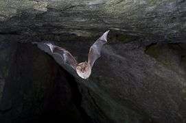
Lesser Horseshoe Bat" 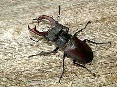
stag beetle
(male).
Adder's tongue. 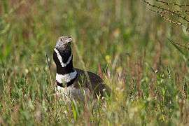
Little bustard.
Gastronomic heritage

The town of Chambourg-sur-Indre is located near Sainte-Maure-de-Touraine where a goat cheese is produced that has geographical indications and traditional specialities in the European Union (Appellation d'origine contrôlée (AOC) in French) status. 24 products in the Chambourg-sur-Indre have a fr:indication géographique protégée (protected geographical indication (PGI)): fr:rillettes de Tours, volailles du Berry (Berry chickens), ins du Val de Loire (Loire Valley wines), de l'Allier, du Cher, de l'Indre, du Pays de Retz et primeur.[88]
Personalities linked to the town
Delataille Emile (1848-1902), carpenter, Compagnons du Tour de France, a member of the National Academy of Fine Arts of the Institute France and the Regional School of Fine Arts in Tours, was born in Chambourg-sur-Indre.[89]
See also
References
- ↑ (French) "Orthodromie entre "Chambourg-sur-Indre" et "Tours"" [Great Circle between "Chambourg-sur-Indre" and "Tours"] (in French). le site lion1906 de Lionel Delvarre. Retrieved 17 September 2014.
- ↑ "Orthodromie entre "Chambourg-sur-Indre" et "Loches"" [Great Circle between "Chambourg-sur-Indre" and "Loches"] (in French). le site lion1906 de Lionel Delvarre. Retrieved 17 September 2014.
- ↑ (Couderc, pp. 47–48)
- 1 2 "Carte géologique de Chambourg-sur-Indre" [Geological map of Chambourg-sur-Indre] (in French). Géoportail. Retrieved 26 Oct 2014.
- ↑ (Couderc, pp. 67–68)
- ↑ "Les sols" [Soils] (in French). le site de la chambre départementale d'agriculture d'Indre-et-Loire. Retrieved 27 October 2014.
- ↑ "Étude des paysages de l'Indre-et-Loire" [Study landscapes of Indre-et-Loire)] (PDF) (in French). Regional Directorate of environment, planning and Housing,. 2001. Retrieved 26 October 2014.
- ↑ Maury, Regis (November 1977). "Les vignobles de la Touraine" [The vineyards of Touraine]. Norois (in French) (95b): 146. Retrieved 26 October 2014.
- ↑ "Répertoire géographique des communes" [Gazetteer of the Communes] (in French). Institut national de l'information géographique et forestière (National Institute of Geographic and Forestry Information). Retrieved 25 October 2014.
- 1 2 3 4 5 (Couderc, p. 240)
- ↑ "Carte hydrologique de Chambourg-sur-Indre" [Hydrological map of Chambourg-sur-Indre] (in French). Géoportail. Retrieved 25 October 2014.
- ↑ "Notice informative sur le risque inondation" [Information notice on flood risk] (PDF) (in French). Services de l'État en Indre-et-Loire (State Services of Indre-et-Loire). Retrieved 17 September 2014.
- ↑ (Gendron, p. 37)
- ↑ "Les climats du monde" [Climates of the World] (in French). l'encyclopédie Larousse. Retrieved 17 September 2014.
- 1 2 3 "Records météorologiques pour Tours entre 1956 et 2012" [Records for weather Tours between 1956 and 2012] (in French). Météo Centre. Retrieved 17 September 2014.
- ↑ "Calcul d'itinéraire Reignac-sur-Indre / Aérodrome de Tours Saint-Symphorien" [Itinerary Reignac-sur-Indre / Tours Saint-Symphorien Airfield] (in French). Via Michelin. Retrieved 30 September 2014.
- ↑ "Infos vols" [Flight info] (in French). l'aéroport de Tours Val-de-Loire. Retrieved 30 September 2014.
- ↑ "Télécharger une fiche horaire" [Download a time sheet] (in French). TER Centre - SNCF. 2014. Retrieved 17 September 2014.
- ↑ "Carte topologique de Chambourg-sur-Indre" [Topological Map of Chambourg-sur-Indre] (in French). GeoPortail. Retrieved 26 October 2014.
- ↑ "rapport d'activités 2013" [Report of Activities 2013] (in French). Municipal Energy Association of Indre-et-Loire. p. 45. Retrieved 17 September 2014.
- ↑ "Urbanisme, travaux / PLU / PPRI (Planning, execution / PLU / IRPP)" (PDF). chambourg-sur-indre.fr. Retrieved 17 September 2014.
- ↑ "Arrêté préfectoral relatif à l'information (...) sur les risques naturels et technologiques majeurs dans la commune de Chambourg-sur-Indre" [Prefectural decree on the information (...) on the major natural and technological hazards in the town of Chambourg-sur-Indre] (PDF) (in French). la Préfecture d’Indre-et-Loire. 24 January 2011. Retrieved 27 October 2014.
- ↑ "Argiles - Aléa retrait-gonflement des argiles - Description du phénomène" [Clays - Hazards of shrinking and swelling clays - Description of the phenomenon] (in French). "Argiles" du Bureau de Recherches Géologiques et Minières (BRGM). Retrieved 27 October 2014.
- ↑ "Argiles - Aléa retrait-gonflement des argiles - Carte d'aléa pour le secteur de Chambourg-sur-Indre" [Clays - Hazard of shrinking and swelling clays - Map of ratings for the sector Chambourg-sur-Indre]. Argiles (in French). BRGM. Retrieved 27 October 2014.
- 1 2 (Gendron, pp. 72–74)
- ↑ Dauzat, Albert; Rostaing, Charles (1 July 1998). Dictionnaire étymologique des noms de lieux en France [Etymological dictionary of names in France] (in French) (2nd ed.). librairie Guénégaud. p. 169a. ISBN 978-2850230769.
- ↑ Delamarre, Xavier (2003). Dictionnaire de la langue gauloise [Dictionary of the Gallic language] (in French). éditions Errance. ISBN 978-2877721981.
- ↑ ibid'
- ↑ L., Capitan (1891). "Nouveau type d'instrument moustérien : le disque racloir" [New Type of Mousterian Instrument: the scraper disk]. Bulletins de la Société d'anthropologie de Paris (in French). Society of Anthropology of Paris. 2, 4th series: 564–565. Retrieved 17 September 2014.
- 1 2 3 4 5 6 7 8 9 (Couderc, p. 241) .
- 1 2 Briais, Bernard (1980). Découvrir la Touraine ; la vallée de l'Indre [Explore Touraine; the Indre Valley] (in French). Illustrated by Brigitte Champion. Chambray-lès-Tours: CLD. p. 203.
- ↑ Briais, Bernard (2010). Le pays lochois et la Touraine côté Sud [Lochois Area and South Touraine] (in French). Chambourg-sur-Indre: Editions PBCO. p. 111. ISBN 978 2 35042 014 1.
- ↑ Elisabeth Zadora-Rio (2010). "Les ressorts administratifs du haut Moyen Age : conditae et vicariae (8e-10e s.)" [Administrative jurisdictions of the High Middle Ages: Conditae and vicariae (8th-10th c.)]. Atlas Archéologique de Touraine (in French). Retrieved 27 October 2014.
- 1 2 (Ranjard, p. 246)
- ↑ (Ranjard, p. 546)
- ↑ Mabille, Emile (1866). "Notice sur les divisions territoriales et la topographie de l'ancienne province de Touraine" [Notice on the territorial divisions and topography of the former province of Touraine]. Bibliothèque de l'École des Chartes (in French). 27: 343. Retrieved 27 October 2014.
- ↑ de Grandmaison Loizeau, Charles (1891). "36". Archives ecclésiastiques antérieures à 1790 - Inventaire sommaire de la série H Clergé régulier – H 12 [Previous ecclesiastical archives to 1790 - Summary Inventory H series regular Clergy - H 12] (PDF) (in French). General Council of Indre-et-Loire.
- ↑ "36". Fours à chaux, tuileries et briqueteries en Indre-et-Loire - 97 J 19 [Lime kilns, tile and brick in Indre-et-Loire - 97 J 19] (PDF) (in French). General Council of Indre-et-Loire. 1996.
- ↑ (Croubois, p. 152)
- ↑ de Grandmaison Loizeau, Charles (1891). Archives ecclésiastiques antérieures à 1790 - Série B Maîtrise des Eaux et Forêts – B 197 [Previous ecclesiastical archives to 1790 - Mastery Series B Forestry - 197 B] (PDF) (in French). General Council of Indre-et-Loire.
- ↑ Leturcq, Samuel (2010). "Changer de paroisse tous les ans... Les tournants et virants de Touraine d'après le pouillé de 1290" [Changing parish every year ... the twisters and turners of Touraine from the pouillé 1290] (PDF). Écritures de l'espace social. HAL archives ouvert (in French). Publications de la Sorbonne: 197–217. ISBN 978-2-85944-654-3. Retrieved 27 October 2014.
- ↑ (Croubois, pp. 354–355)
- ↑ "État récapitulatif des fiches de la commune 37049 - Chambourg-sur-Indre" [Summary of documents of commune 37049 - Chambourg-sur-Indre]. Mémorial GenWeb (in French). France GenWeb. Retrieved 27 October 2014.
- ↑ (Briais, p. 24)
- ↑ (Briais, p. 40)
- ↑ (Briais, pp. 51–52)
- ↑ (Briais, p. 151)
- ↑ "Résultats des élections législatives 2012" [Parliamentary Election Results 2012] (in French). ministère de l'Intérieur. Retrieved 17 September 2014.
- ↑ "Résultats de l'élection présidentielle 2007" [Results of the 2007 (French) Presidential Election] (in French). ministère de l'Intérieur. Retrieved 17 September 2014.
- ↑ "Résultats de l'élection présidentielle 2012" [Results of the 2023 (French) Presidential Election] (in French). Ministry of the Interior. Retrieved 17 September 2014.
- ↑ "Code général des collectivités territoriales - Article L2121-2". legifrance.gouv.fr. 17 May 2013. Retrieved 27 October 2013.
- ↑ "Résultats des élections municipales 2008" [Results of Municipal Elections 2008] (in French). Minister of the Interior. Retrieved 17 September 2014.
- ↑ "Résultats des élections municipales et communautaires 2014" [Results of Municipal and Community Elections 2014] (in French). Minister of the Interior. Retrieved 17 September 2014.
- ↑ "Archives départementales d'Indre-et-Loire - Collection des registres d'état civil numérisés" [Departmental Archives of Indre-et-Loire - Collection of digital vital records] (in French). General Council of Indre-et-Loire. Retrieved 17 September 2014.
- ↑ "Laurent Couraud élu Mayre" [Laurent Couraud Elected Mayor] (in French). La Nouvelle République du Centre-Ouest. 1 April 2014. Retrieved 17 September 2014.
- ↑ "Les juridictions" [The Courts] (in French). conseil départemental de l'accès aux droits d'Indre-et-Loire. Retrieved 28 October 2014.
- ↑ "Brigade la plus proche / Chambourg-sur-Indre" [Nearest Brigade / Chambourg-sur-Indre] (in French). National Gendarmerie. Retrieved 28 October 2014.
- ↑ "Missions et compétences" [Tasks and responsibilities] (in French). syndicat intercommunal d'énergie d'Indre-et-Loire. Retrieved 28 October 2014.
- ↑ "Compte rendu de la réunion du SI de transport scolaire du Lochois du 24 novembre 2008" [Minutes of the meeting of the SI busing of Lochois of November 24, 2008] (PDF) (in French). la mairie de Ferrière-sur-Beaulieu. Retrieved 27 October 2014.
- ↑ "Contexte géographique et géologique - Séno-turonien" [Geographical and geological context - Seno-Turonian] (in French). BRGM - Système d’information pour la gestion des eaux souterraines en région Centre (SIGES Centre). Retrieved 28 October 2014.
- ↑ "Ouvrages CC Loches Développement" [CC Loches Development Words] (in French). l'observatoire national des services d'eau et d'assainissement. Retrieved 28 October 2014.
- ↑ "Comptes de la commune de Chambourg-sur-Indre" [Accounts of the Municipality of Chambourg-sur-Indre] (in French). ministère des Finances. Retrieved 28 October 2014.
- ↑ "Mémento financier et fiscal du maire" [Mayor's Financial Report] (PDF) (in French). ministère du Budget. April 2008. p. 34. Retrieved 28 October 2014.
- ↑ "Annuaire des établissements d'enseignement public - Écoles de Chambourg-sur-Indre" [Directory of public educational institutions - Schools in Chambourg-sur-Indre] (in French). ministère de l'Éducation nationale. Retrieved 28 October 2014.
- ↑ "Annuaire des établissements d'enseignement public - Collèges de Loches" [Directory of public educational institutions - Colleges of Loches] (in French). Ministère de l'Éducation nationale. Retrieved 28 October 2014.
- ↑ "Annuaire des établissements d'enseignement public - Lycées de Loches" [Directory of public schools - High schools of Loches] (in French). Ministère de l'Éducation nationale. Retrieved 28 October 2014.
- ↑ "Découverte du territoire / Enseignement supérieur et recherche" [Exploring the Territory / Higher Education and Research] (in French). communauté d'agglomération de Tours. Retrieved 28 October 2014.
- ↑ "Tours-Fondettes agrocampus" [Tours-Fondettes Agricultural Campus] (in French). Ministère de l'Agriculture. Retrieved 28 October 2014.
- ↑ "Chambourg-sur-Indre Star'Ac et musique gipsy" [Chambourg-sur-Indre Star'Ac and Gipsy Music]. La nouvelle République du Centre-ouest (in French). 21 July 2013. Retrieved 28 October 2014.
- ↑ "Bibliothèque de Chambourg-sur-Indre" [Chambourg-sur-Indre Library] (in French). Lire en Touraine. 2012. Retrieved 17 September 2014.
- ↑ "Accueil / Indre-et-Loire / Chambourg-sur-Indre" [Welcome / Indre-et-Loire / Chambourg-sur-Indre] (in French). l'association Fédération ASSO1901. Retrieved 28 October 2014.
- ↑ "Trouver un établissement" [Find an establishment] (in French). Fédération hospitalière de France. Retrieved 28 October 2014.
- ↑ "Page d'accueil" (in French). La Renaissance lochoise. Retrieved 28 October 2014.
- ↑ "Page de présentation" [Front page] (in French). la station de radio "Graffic". Retrieved 28 October 2014.
- ↑ "Central de Chambourg (37049CI1 - CI137)" (in French). société Ariase SARL. Retrieved 28 October 2014.
- ↑ "Recensement agricole 2010 - Principaux résultats par commune" [Agricultural Census 2010 - Key findings by town]. Agreste (in French). service de la statistique et de la prospective (SSP) du ministère de l’Agriculture, de l’Agroalimentaire et de la Forêt. Retrieved 27 October 2014.
- ↑ Frachot, Stephen (27 December 2013). "Panneaux routiers : SES rénove son parc de machines" [Road signs: SES renovates its machinery]. Les Échos (in French). Retrieved 28 October 2014.
- ↑ "Notre histoire" [Our History] (in French). SES Sécurité et Signalisation. Retrieved 28 October 2014.
- ↑ "Location de vacances Chambourg-sur-Indre- Gîtes de France® Chambourg-sur-Indre" [Holiday rentals in Chambourg-sur-Indre Gîtes de France Chambourg-sur-Indre] (in French). SAS Gîtes de France. Retrieved 28 October 2014.
- ↑ "Monuments historiques - Vestiges du pont sur l'Indre du 15e siècle" [Monuments - Remnants of the bridge over the Indre built in the 5th century] (in French). Ministry of Interior. Retrieved 31 October 2014..
- ↑ Archives départementales d'Indre-et-Loire. "extrait du cadastre napoléonien - Chambourg, L'isle Auger, section B2" [Extract of the Napoleonic cadastre - Chambourg, L'isle Auger, section B2] (in French). conseil général d'Indre-et-Loire. Retrieved 31 October 2014..
- ↑ de la Brosse, Gaëlle (27 March 2014). "Renaissance des chemins de saint Martin" [Renaissance of St. Martin Roads]. Pèlerin (in French). Retrieved 31 October 2014..
- ↑ Meunier, Christophe (2006). Genillé... au fil des temps [Genillé over ... time] (in French). Chemillé-sur-Indrois: Éditions Hugues de Chivré. pp. 52–58. ISBN 978-2916043104..
- ↑ "ZNIEFF 240031220 - MASSIF FORESTIER DE LOCHES" [ZNIEFF 240031220 - LOCHES FOREST] (in French). Inventaire national du patrimoine naturel. Retrieved 31 October 2014.
- ↑ "Les mesures agri-environnementales territorialisées" [Regional Agri-environmental Measures] (in French). l'Atelier technique des espaces naturels du ministère de l'Écologie, du Développement durable et de l'Énergie. Retrieved 31 October 2014.
- ↑ "Arrêté définissant les secteurs où la présence de la loutre ou du castor d'Eurasie est avérée pour la campagne 2014-2015" [Order defining the areas where the presence of the otter or beaver Eurasia is to be demonstrated for the 2014-2015 campaign] (PDF) (in French). Fédération régionale des chasseurs du Centre. Retrieved 31 October 2014.
- ↑ "GR 46 - De Artannes-sur-Indre (Indre-et-Loire) à Buzançais (Indre)" [GR 46 - From Artannes-sur-Indre (Indre-et-Loire) to Buzançais (Indre)] (in French). GR Infos - Sentiers de Grande Randonnée. Retrieved 31 October 2014..
- ↑ "Liste des produits par commune - Chambourg-sur-Indre" [List of products by town - Chambourg-sur-Indre] (in French). nstitut national de l'Origine et de la Qualité (INAO). Retrieved 31 October 2014..
- ↑ "Qui était Émile Delataille ?" [Who was Emile Delataille?] (in French). lycée Émile-Delataille de Loches. Retrieved 31 October 2014..
Notes
- ↑ Flood plain refer to when the level of a river, usually following heavy rainfall, rises slowly until inundation of the flood plain, for a longer or shorter period.
- 1 2 3 4 5 These remarks are not the result of a statistical analysis of the data presented. They are only indicative.
- ↑ This image is a photo-editing: the sign is actually farther from the bridge.
- ↑ Mayor Robellandes dies in office.
- ↑ Deputy Mayor Douard served as acting mayor after the death of Mr. Mayor Robellandes.
- ↑ Mayor Lucien Monnessier died while in office.
- ↑ Deputy Mayor Jean Arrault served as acting mayor after the death of Mayor Lucien Monnessier.
- ↑ Mayor Stephen Gripouilleau died while in office.
- ↑ Deputy Mayor Jean Arrault acted as mayor after the death of Mayor Stephen Gripouilleau.
- ↑ Deputy Mayor Louis Girard acted as mayor after the death of Mayor Stephen Gripouilleau.
- ↑ Mayor Emile Douard died while in office.
- ↑ Deputy Mayor Leon Marcadier was acting mayor after the death of Mayor Emile Douard.
- ↑ The accounting profit is the difference between operating income and expenses.
- ↑ The need or ability to finance investments is the difference between resources and investment projects; if resources exceed the cost of projects, there is excess financing capacity; higher cost of projects indicates a need for funding.
- ↑ The "cash flow" is the surplus from operations; This allows the use of surplus to make debt repayments. The surplus (cash flow - debt repayments) in addition to investment income (grants, subsidies, plus capital gains) is used to fund capital expenditures. This amount represents the funding available to the commune
- ↑ Translator's note: The format for populations pyramids in the French Wikipedia is different from the English (which requires five year increments). The translator invites a willing party to research the population ages in five year increments and a population pyramid similar to the one in the French article.
- ↑ In the early twenty-first century, the terms of the census were amended by Law No. 2002-276 of 27 February 2002, namely "Act of grassroots democracy" on local democracy and in particular Title V "census operations" to allow, after a transitional period running from 2004 to 2008, the annual publication of the legal population of the different French administrative districts. For municipalities with a population greater than 10,000 people, a survey is conducted annually, the entire territory of these municipalities is taken into account at the end of the five-year period. Later than the first of 1999 and enrolling in this new legal device population came into force on 1 January 2009 and corresponds to the census of 2006.
- ↑ In the table and graph of the censuses, by convention in Wikipedia, and to allow a proper comparison between spaced a five-year period censuses, the principle was applied for after 1999 official population of only displaying in the table and graph census populations for the years 2006, 2011, 2016, etc., as well as the latest legal population published by INSEE.
- ↑ Due to rounding of the first decimal values provided by INSEE, totals may appear inaccurate.
- ↑ This information, which cannot be confirmed from any source, appears to be a common belief of the area.
INSEE site
- ↑ "Code officiel géographique - présentation" [Official Geographic Code - Presentation] (in French). INSEE. Retrieved 25 October 2014.
- ↑ "Population, superficie et densité des principaux pays du Monde en 2013" [Population, area and density of the major countries of the World in 2013] (in French). INSEE. Retrieved 25 October 2014.
- 1 2 3 "Chiffres clés - Logement en 2011 à Chambourg-sur-Indre" [Key figures - Housing in Chambourg-sur-Indre in 2001]. insee.fr (in French). Retrieved 17 September 2014.
- 1 2 "Chiffres clés - Logement en 2011 en Indre-et-Loire" [Key figures - Housing in Indre-et-Loire in 2011]. insee.fr (in French). Retrieved 17 September 2014.
- ↑ "POP T2M - Indicateurs démographiques" [POP T2M - Demographic Indicators] (in French). INSEE. Retrieved 28 October 2014.
- 1 2 "CEN T1 - Établissements actifs par secteur d'activité au 31 décembre 2011" [CEN T1 - Active Establishments by Business December 31, 2011] (in French). INSEE. December 31, 2011. Retrieved 28 October 2014.
- ↑ "DEN T1 - Créations d'entreprises par secteur d'activité en 2012" [DEN T1 - Creation of companies by industry in 2012] (in French). INSEE. 2012. Retrieved 28 October 2014.
- ↑ "DEN T4 - Créations d'établissements par secteur d'activité en 2013" [T4 DEN - Creation of establishments by industry in 2013] (in French). INSEE. Retrieved 28 October 2014.
- ↑ "Chiffres clés Tourisme" [Key Figures for Tourism] (in French). INSEE. Retrieved 28 October 2014.
- ↑ "Fichier RFDM2011COM : Revenus fiscaux localisés des ménages - Année 2011" [File RFDM2011COM: Local Tax Revenue of Households - Year 2011]. insee.fr (in French). Retrieved 28 October 2014.
- ↑ "REV T1 Impôt sur le revenu des foyers fiscaux - Chambourg-sur-Indre" [REV T1 tax income tax households - Chambourg-sur-Indre] (in French). INSEE. Retrieved 28 October 2014.
- ↑ "REV T1 Impôt sur le revenu des foyers fiscaux - Indre-et-Loire" [REV T1 income tax for households - Indre-et-Loire] (in French). INSEE. Retrieved 28 October 2014.
- ↑ "EMP T1 - Population de 14 à 64 ans par type d'activité" [EMP T1 - Population 14-64 years old by type of activity] (in French). INSEE. Retrieved 28 October 2014.
- ↑ "EMP T5 - Population Emploi et activité." [EMP T5 - Population and employment activity.] (in French). INSEE. Retrieved 28 October 2014.
- ↑ "ACT T4 - Lieu de travail des actifs de 15 ans ou plus ayant un emploi qui résident dans la zone" [ACT T4 - Location of job seekers 15 years or older with a job residing in the area] (in French). INSEE. Retrieved 28 October 2014.
Commune official website
- ↑ "Accueil : parking co-voiturage" [Welcome to Car-park]. chambourg-sur-indre.fr (in French). Retrieved 17 September 2014.
- 1 2 "Urbanisme - Travaux : le Plan local d'Urbanisme" [Planning and Public Works: Local Development Plan]. chambourg-sur-indre.fr (in French). Retrieved 17 September 2014.
- ↑ "Mairie : inauguration caserne" [Mayor's Office: inauguration of firestation] (PDF). chambourg-sur-indre.fr (in French). Retrieved 17 September 2014.
- ↑ "Mairie : compte-rendus des réunions du conseil municipal" [Mayor's Office: Records of council meetings] (PDF). chambourg-sur-indre.fr (in French). Retrieved 17 September 2014.
- 1 2 "Histoire". Mairie de Chambourg-sur-Indre. Retrieved 27 October 2014.
- ↑ "Salles polyvalentes" [Multipurpose rooms] (in French). chambourg-sur-indre.fr. Retrieved 28 October 2014.
- ↑ "Renseignements pratiques" [Practical Information]. chambourg-sur-indre.fr (in French). Retrieved 28 October 2014.
- ↑ "Artisans - Loisirs - Tourisme ; Hébergement" [Artisans - Leisure - Tourism; accommodation] (in French). chambourg-sur-indre.fr. Retrieved 28 October 2014.
Community website for Shared Loches Development
- ↑ "Eau et assainissement" [Water and Sewers] (in French). communauté de communes Loches Développement. Retrieved 27 October 2014.
- ↑ "Rapport annuel sur le prix et la qualité du service public de l'eau potable" (PDF). Communauté de Communes Loches Développement. Retrieved 28 October 2014.
- ↑ "Rapport annuel sur le Prix et la Qualité du Service public de l'assainissement collectif" [Annual Report on the Price and Quality of Collective Public Sanitation Service] (PDF) (in French). Communauté de Communes Loches Développement. 2012. Retrieved 27 October 2014.
- ↑ "Déchets ménagers" [Trash]. lochesdeveloppement.com (in French). Retrieved 28 October 2014.
- ↑ "Natura 2000 - Champeigne" (in French). Communaute de Commune de Loches Developpement. Retrieved 31 October 2014..
Bibliography
- Briais, Bernard (1988). Le Lochois pendant la guerre 1939-1945 [The Lochois during the 1939-1945 war] (in French). Chambray-lès-Tours: CLD. p. 191. Briais.
- Couderc, Jean-Mary (1987). Dictionnaire des communes de Touraine [Dictionary of the Communes of Touraine] (in French). Chambray-lès-Tours: C.L.D. p. 967. ISBN 978-2854431360.
- Croubois, Claude (1986). L’indre-et-Loire – La Touraine, des origines à nos jours [The Indre-et-Loire - La Touraine, from its origins to today]. L’histoire par les documents (in French). Saint-Jean-d’Angely: Bordessoules. p. 470. ISBN 2 90350 409 1. Croubois.
- Gendron, Stéphane (2012). L'origine des noms de lieux de l'Indre-et-Loire [The origin of the place names of the Indre-et-Loire] (in French). Chemillé-sur-Indrois: Hugues de Chivré. p. 303. ISBN 978-2916043456.
- Ranjard, Robert (1986). La Touraine archéologique [Archaeology of Touraine] (in French). Mayenne: Imprimerie de la Manutention. p. 735. ISBN 978-2-855-54017-7. Ranjard.
External links
| Wikimedia Commons has media related to Chambourg-sur-Indre. |
- (French) Website of the mayor's office