Clairvaux-d'Aveyron
| Clairvaux-d'Aveyron | |
|---|---|
|
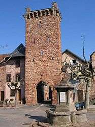
The entrance gate in Clairvaux-d'Aveyron | |
 Clairvaux-d'Aveyron | |
|
Location within Occitanie region  Clairvaux-d'Aveyron | |
| Coordinates: 44°25′42″N 2°24′41″E / 44.4283°N 2.4114°ECoordinates: 44°25′42″N 2°24′41″E / 44.4283°N 2.4114°E | |
| Country | France |
| Region | Occitanie |
| Department | Aveyron |
| Arrondissement | Rodez |
| Canton | Marcillac-Vallon |
| Intercommunality | Causse et Vallon de Marcillac |
| Government | |
| • Mayor (2008–2014) | Jean-Marie Lacombe |
| Area1 | 25.14 km2 (9.71 sq mi) |
| Population (2008)2 | 1,135 |
| • Density | 45/km2 (120/sq mi) |
| Time zone | CET (UTC+1) |
| • Summer (DST) | CEST (UTC+2) |
| INSEE/Postal code | 12066 / 12330 |
| Elevation |
319–734 m (1,047–2,408 ft) (avg. 432 m or 1,417 ft) |
|
1 French Land Register data, which excludes lakes, ponds, glaciers > 1 km² (0.386 sq mi or 247 acres) and river estuaries. 2 Population without double counting: residents of multiple communes (e.g., students and military personnel) only counted once. | |
Clairvaux-d'Aveyron is a commune in the Aveyron department in southern France.
Population
| Historical population | ||
|---|---|---|
| Year | Pop. | ±% |
| 1806 | 2,411 | — |
| 1821 | 2,200 | −8.8% |
| 1831 | 2,266 | +3.0% |
| 1836 | 2,070 | −8.6% |
| 1841 | 2,318 | +12.0% |
| 1846 | 2,559 | +10.4% |
| 1851 | 2,523 | −1.4% |
| 1856 | 2,400 | −4.9% |
| 1861 | 2,450 | +2.1% |
| 1866 | 1,925 | −21.4% |
| 1872 | 1,807 | −6.1% |
| 1876 | 1,940 | +7.4% |
| 1881 | 1,796 | −7.4% |
| 1886 | 1,853 | +3.2% |
| 1891 | 1,826 | −1.5% |
| 1896 | 1,788 | −2.1% |
| 1901 | 1,718 | −3.9% |
| 1906 | 1,593 | −7.3% |
| 1911 | 1,639 | +2.9% |
| 1921 | 1,470 | −10.3% |
| 1926 | 1,502 | +2.2% |
| 1931 | 1,419 | −5.5% |
| 1936 | 1,395 | −1.7% |
| 1946 | 1,262 | −9.5% |
| 1954 | 1,031 | −18.3% |
| 1962 | 937 | −9.1% |
| 1968 | 834 | −11.0% |
| 1975 | 857 | +2.8% |
| 1982 | 923 | +7.7% |
| 1990 | 911 | −1.3% |
| 1999 | 1,039 | +14.1% |
| 2008 | 1,135 | +9.2% |
See also
References
| Wikimedia Commons has media related to Clairvaux-d'Aveyron. |
This article is issued from Wikipedia - version of the 2/12/2016. The text is available under the Creative Commons Attribution/Share Alike but additional terms may apply for the media files.