Yarrowitch River
Yarrowitch River, a perennial stream of the Macleay River catchment, is located in the Northern Tablelands district of New South Wales, Australia.
Course and features
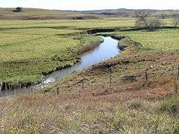
Yarrowitch River rises within Mummel Gulf National Park on the northern slopes of the Great Dividing Range southwest of Yarrowitch, and flows generally north northeast, joined by the Warnes River before reaching its confluence with the Apsley River, southwest of Tia. The river descends 822 metres (2,697 ft) over its 62 kilometres (39 mi) course;[2] spilling over the Yarrowitch Falls in the Oxley Wild Rivers National Park.
In its middle reaches, the Yarrowitch River passes through rich grazing country used for rearing livestock, principally beef cattle.
See also
References
External links
|
|---|
|
| |
|---|
|
- Oxley
- Rous
- Tweed
- Byrrill
- Cudgen
- Cudgera
- Crystal
- Doon Doon
- Dunbible
- Hopkins
- Hopping Dicks
- Jacksons
- Korrumbyn
- Mooball
- Nobbys
- Rolands
- Smiths
- Tyalgum
|
|
|
| |
|---|
|
- Brunswick
- Belongil
- Broken Head
- Kings
- Mullumbimby
- Simpsons
- Tallow
|
|
|
| |
|---|
|
- Back
- Coopers
- Eden
- Evans
- Leycester
- Richmond
- Sandy
- Shannon
- Wilsons
- Bingeebeebra
- Black Horse
- Boomerang
- Boorabee
- Branch
- Bungawalbin
- Byrangery
- Calico
- Cherry Tree
- Cob O'Corn
- Deep
- Doubtful
- Dyraaba
- Emigrant
- Fawcetts
- Findon
- Goolmangar
- Gradys
- Horse Station
- Iron Pot
- Jeffries
- Jiggi
- Lynchs
- Mongogarie
- Mulgum
- Oaky
- O'Donnell
- Rileys
- Rose
- Roseberry
- Salty Lagoon
- Simpkins
- Smiths
- Terrace
- Terania
- Theresa
- Tuntable
- Wyndham
- Yankey
|
|
|
|
|
| |
|---|
|
- Bellinger
- Kalang
- Never Never
- Rosewood
- Arrawarra
- Boambee
- Boggy
- Bonville
- Bundageree
- Coffs
- Cooks
- Dalhousie
- Darkum
- Flat Top Point
- Hearns
- Hydes
- Moonee
- Pine Brush
- Pipe Clay
- Woods
- Woolgoolga Lake
|
|
|
|
|
|
|
|
Coordinates: 31°02′S 152°03′E / 31.033°S 152.050°E / -31.033; 152.050