Dilgry River
| Dilgry River | |
| Perennial river[1] | |
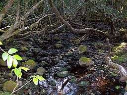 Dilgry River, with Antarctic Beech, at elevation 1,420 metres (4,660 ft) | |
| Country | Australia |
|---|---|
| State | New South Wales |
| Regions | New England Tablelands (IBRA), NSW North Coast, Upper Hunter, Mid North Coast |
| Local government area | Mid-Coast Council |
| Part of | Manning River catchment |
| Source | Mount Royal Range, Barrington Tops, Great Dividing Range |
| - location | near Tunderbolts Lookout, Barrington Tops National Park |
| - elevation | 1,440 m (4,724 ft) |
| Mouth | confluence with the Cobark River |
| - location | near Boranel Mountain |
| - elevation | 339 m (1,112 ft) |
| Length | 27 km (17 mi) |
| National park | Barrington Tops |
| Waterfall | Dilgry Falls |
| [2] | |
Cobark River, a perennial river of the Manning River catchment, is located in the Upper Hunter district of New South Wales, Australia.
Course and features
Dilgry River rises in the Barrington Tops within the Great Dividing Range, near Tunderbolts Lookout in the Barrington Tops National Park, and flows generally east then south by east, before reaching its confluence with the Cobark River, north north east of Boranel Mountain. The river descends 1,100 metres (3,600 ft) over its 26 kilometres (16 mi) course.[2]
See also
References
- ↑ "Dilgry River". Geographical Names Register (GNR) of NSW. Geographical Names Board of New South Wales. Retrieved 16 March 2013.
- 1 2 "Map of Dilgry River, NSW". Bonzle Digital Atlas of Australia. Retrieved 16 March 2013.
River systems and rivers of Hunter-Central Rivers catchment, New South Wales, Australia | |||||||
|---|---|---|---|---|---|---|---|
| |||||||
| |||||||
| |||||||
|
Coordinates: 31°56′S 151°40′E / 31.933°S 151.667°E
This article is issued from Wikipedia - version of the 7/26/2016. The text is available under the Creative Commons Attribution/Share Alike but additional terms may apply for the media files.