Stjørdal
| Stjørdal kommune | |||
|---|---|---|---|
| Municipality | |||
 | |||
| |||
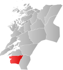 Stjørdal within Nord-Trøndelag | |||
| Coordinates: 63°28′30″N 011°10′15″E / 63.47500°N 11.17083°ECoordinates: 63°28′30″N 011°10′15″E / 63.47500°N 11.17083°E | |||
| Country | Norway | ||
| County | Nord-Trøndelag | ||
| District | Stjørdalen | ||
| Administrative centre | Stjørdalshalsen | ||
| Government | |||
| • Mayor (2013) | Ivar Vigdenes (Sp) | ||
| Area | |||
| • Total | 938.05 km2 (362.18 sq mi) | ||
| • Land | 913.26 km2 (352.61 sq mi) | ||
| • Water | 24.79 km2 (9.57 sq mi) | ||
| Area rank | 117 in Norway | ||
| Population (2011) | |||
| • Total | 21,659 | ||
| • Rank | 48 in Norway | ||
| • Density | 23.7/km2 (61/sq mi) | ||
| • Change (10 years) | 17.3 % | ||
| Demonym(s) | Stjørdaling[1] | ||
| Time zone | CET (UTC+1) | ||
| • Summer (DST) | CEST (UTC+2) | ||
| ISO 3166 code | NO-1714 | ||
| Official language form | Neutral | ||
| Website |
www | ||
|
| |||

![]() Stjørdal is a municipality in Nord-Trøndelag county, Norway. It is part of the Stjørdalen region. The administrative centre of the municipality is the town of Stjørdal, also called Stjørdalshalsen. Other villages in the municipality include Elvran, Flornes, Hegra, Hell, Kvithammer, Prestmoen, Skatval, Skjelstadmarka, Sona, and Værnes.
Stjørdal is a municipality in Nord-Trøndelag county, Norway. It is part of the Stjørdalen region. The administrative centre of the municipality is the town of Stjørdal, also called Stjørdalshalsen. Other villages in the municipality include Elvran, Flornes, Hegra, Hell, Kvithammer, Prestmoen, Skatval, Skjelstadmarka, Sona, and Værnes.
The municipality is known for the village of Hell which is located in the Lånke area of Stjørdal. Hell is especially known for its train station, Hell Station, where you find the old sign saying Godsexpedition (meaning "Cargo handling").
General information

Stjørdalen was established as a municipality on 1 January 1838 (see formannskapsdistrikt). On 1 January 1850, Stjørdalen was divided into Øvre Stjørdal and Nedre Stjørdal. Later, Øvre Stjørdal was divided into Hegra and Meråker on 1 January 1874 and Nedre Stjørdal was divided into Lånke, Skatval, and (a smaller) Stjørdal on 1 January 1902. All of these municipalities (except for Meråker) were merged on 1 January 1962 to form a new, larger Stjørdal municipality.[2]
Name
The Old Norse form of the name was Stjórardalr. The first element is the genitive case of the river name Stjór (now called Stjørdalselva) and the last element is dalr which means "valley" or "dale". The meaning of the river name is unknown.[3]
The pronunciation of the name Stjørdal in the local dialect is [ʃøɽdaɽːɲ].
Coat of arms and flag
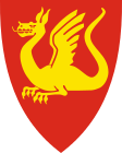
On September 29, 1983, by resolution of its municipal council, Stjørdal adopted a new municipal coat of arms in red and gold, bearing a gold or yellow Lindworm (a two-legged dragon or wyvern) on a field of red.[4] The arms were granted on November 25, 1983.[5]
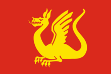
Most Norwegian municipalities have a banner of their respective coats of arms as a flag, and accordingly, the municipal flag of Stjørdal similarly bears a yellow wyvern on a red field.
Although the coat of arms is from modern times, the dragon motif of the arms was inspired by a medieval seal for the district, dating from 1344.[6] The old municipal seal was considered unsuitable for selection as the municipal coat of arms, because to obtain a municipal coat of arms and flag, a Norwegian municipality must fulfill certain heraldic requirements that do not apply to a seal.[4] For example, a coat of arms will generally contain only one pictorial motif, while Stjørdal's seal had three motifs and failed to meet additional requirements concerning color elements.[4] The municipality sought assistance from the National Archives of Norway, and was referred to archivist Hallvard Trætteberg, resulting in a collaboration to develop the new coat of arms.[4]
The dragon is a symbol of Saint Margaret of Antioch, and its depiction is derived from Stjørdal's old seal, which showed Saint Margaret standing on a slain dragon.[4][7] According to Stjørdal's municipal website, both the four-legged dragon and the two-legged wyvern are used in ancient designs of arms going back thousands of years, and have "always stood as a symbol of authority, power, and exalted dignity of great national cultures."[4]
Churches
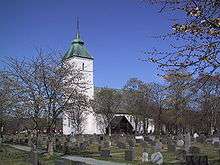
The Church of Norway has four parishes (sokn) within the municipality of Stjørdal. It is part of the Stjørdal deanery and the Diocese of Nidaros.
| Parish (Sokn) | Church Name | Location of the Church | Year Built |
|---|---|---|---|
| Hegra | Hegra Church | Hegra | 1783 |
| Flora Chapel | Flornes | 1936 | |
| Okkelberg Chapel | Skjelstadmarka | 1905 | |
| Lånke | Lånke Church | Lånke | 1899 |
| Elvran Chapel | Elvran | 1893 | |
| Skatval | Skatval Church | Skatval | 1901 |
| Stjørdal | Værnes Church | Prestmoen | 1100 |
History
| Historical population | ||
|---|---|---|
| Year | Pop. | ±% |
| 1951 | 5,105 | — |
| 1960 | 6,128 | +20.0% |
| 1970 | 13,545 | +121.0% |
| 1980 | 16,107 | +18.9% |
| 1990 | 17,276 | +7.3% |
| 2000 | 18,238 | +5.6% |
| 2010 | 21,375 | +17.2% |
| 2011 | 21,659 | +1.3% |
| Source: Statistics Norway. | ||


Stjørdal is the location of Steinvikholm Castle, the residence of Norway's last Catholic archbishop, Olav Engelbrektsson. It is located on the Skatval peninsula.
Hegra Fortress is located in the central part of the municipality. It was used as a defense against the Swedish military. It was also used during World War II in the Battle of Hegra Fortress.
Government
All municipalities in Norway, including Stjørdal, are responsible for primary education (through 10th grade), outpatient health services, senior citizen services, unemployment and other social services, zoning, economic development, and municipal roads. The municipality is governed by a municipal council of elected representatives, which in turn elect a mayor.
Municipal council
The municipal council (Kommunestyre) of Stjørdal is made up of 41 representatives that are elected to every four years. Currently, the party breakdown is as follows:[8]
| Party Name | Name in Norwegian | Number of representatives | |
|---|---|---|---|
| Labour Party | Arbeiderpartiet | 16 | |
| Progress Party | Fremskrittspartiet | 2 | |
| Conservative Party | Høyre | 6 | |
| Christian Democratic Party | Kristelig Folkeparti | 1 | |
| Green Party | Miljøpartiet De Grønne | 1 | |
| Red Party | Rødt | 1 | |
| Centre Party | Senterpartiet | 11 | |
| Socialist Left Party | Sosialistisk Venstreparti | 1 | |
| Liberal Party | Venstre | 2 | |
| Total number of members: | 41 | ||
Geography
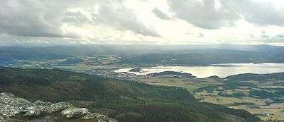
Stjørdal consists of the old municipalities of Skatval, Hegra, Lånke, and Stjørdal. The Stjørdalselva river runs through the Stjørdalen valley, with the Skatval peninsula on the northern side. The Forbordsfjellet mountain sits in the northern part of the municipality. The Skarvan and Roltdalen National Park lies in the eastern part of the municipality, as is a tiny part of the lake Feren.
The village of Stjørdal declared township in 1997. Stjørdal is the fastest growing municipality in Nord-Trøndelag due to its proximity to the city of Trondheim and also to Statoil's presence (it controls a large part of the petroleum activity in the Norwegian Sea from Stjørdal).
Trondheim is only about 32 kilometres (20 mi) from Stjørdal either by road (European route E6) or train (Trønderbanen). Stjørdal is in the process of "growing together" with Trondheim, a show of regional urbanization. The distance to Steinkjer is about 90 kilometres (56 mi), and the towns of Levanger and Verdal are both about 48 to 60 kilometres (30 to 37 mi) to the north. All four of these towns are located on the eastern shore of the Trondheimsfjorden. Stjørdal is now considered a part of Trondheim due to its urbanization process and close location
Birdlife
The Stjørdal area has a rich bird life with well over 260 recorded species and several good birding localities. Though Stjørdal can not boast of a long coastline (it's only 25 kilometres or 16 miles long) some of best birding areas are to be found along Stjørdalfjorden. Halsøen is virtually situated near the centre of Stjørdal, and can be easily viewed from a number of advantage points from route E6 in the east or Langøra in the west. Formed by the old river outlet, this tidal area is well worth checking. Due to the shallow waters and extensive areas of mud at low tide, Halsøen is used both as a wintering area and a migration stopover point by many species.
Transportation
Stjørdal is a regional transportation centre that is near the regional airport, Trondheim Airport, Værnes, as well as port facilities, European route E6, European route E14, and the Nordlandsbanen railway line going through the municipality from Trondheim to Bodø with stops at Hell Station, Trondheim Airport Station, Stjørdal Station, and Skatval Station. In addition, the Meråkerbanen railway line goes from Hell east to Åre Municipality in Sweden. Stations on that railway line include Hell Station, Hegra Station, Sona Station, and Flornes Station.
Twin cities
References
- ↑ "Navn på steder og personer: Innbyggjarnamn" (in Norwegian). Språkrådet. Retrieved 2015-12-01.
- ↑ Jukvam, Dag (1999). "Historisk oversikt over endringer i kommune- og fylkesinndelingen" (PDF) (in Norwegian). Statistisk sentralbyrå.
- ↑ Rygh, Oluf (1903). Norske gaardnavne: Nordre Trondhjems amt (dokpro.uio.no) (in Norwegian) (15 ed.). Kristiania, Norge: W. C. Fabritius & sønners bogtrikkeri. p. 30.
- 1 2 3 4 5 6 "Kommunevåpen (Municipal Arms)". Stjørdal Kommune. Archived from the original on 2015-01-14.
- ↑ Heimer, Željko (2007). "Stjørdal, Nord-Trøndelag (Norway)". Flags of the World. Archived from the original on 2013-03-08.
- ↑ Norske Kommunevåpen (1990). "Nye kommunevåbener i Norden". Retrieved 17 November 2008.
- ↑ Hartemink, Ralf. "Stjørdal". Civic heraldry of Norway/Norske Kommunevåpen. Heraldry of the World. Archived from the original on 2015-01-14.
- ↑ "Table: 04813: Members of the local councils, by party/electoral list at the Municipal Council election (M)" (in Norwegian). Statistics Norway. 2015.
- ↑ "Kolme vuosikymmentä pohjoismaisia ystäväkuntasuhteita Karstulassa" (PDF) (in Finnish). Karstulan Pohjola-Norden ry. Retrieved 7 May 2012.
External links
| Wikimedia Commons has media related to Stjørdal. |
- Official website
 Nord-Trøndelag travel guide from Wikivoyage
- Municipal fact sheet from Statistics Norway
- Angling in the Stjørdalselva (river)