CT postcode area

Postcode district boundaries: Bing / Google

KML is from Wikidata
Canterbury postcode area
CT
Postcode area CT
Postcode area name Canterbury
Post towns 13
Postcode districts 22
Postcode sectors 83
Postcodes (live) 14,730
Postcodes (total) 18,844
Statistics as at February 2012[1]

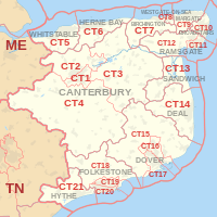
The CT postcode area, also known as the Canterbury postcode area,[2] is a group of 21 postcode districts in England, which are subdivisions of 13 post towns. These postcode districts cover much of East Kent, including Canterbury, Dover, Folkestone, Birchington, Broadstairs, Deal, Herne Bay, Hythe, Margate, Ramsgate, Sandwich, Westgate-on-Sea and Whitstable.

Coverage

The approximate coverage of the postcode districts:

Postcode district Post town Coverage Local authority area
CT1 CANTERBURY Canterbury (south and city centre) Canterbury
CT2 CANTERBURY Canterbury (north), Harbledown, Rough Common, Sturry, Fordwich, Blean, Tyler Hill, Broad Oak, Westbere Canterbury
CT3 CANTERBURY Wingham Canterbury, Dover
CT4 CANTERBURY Chartham, Bridge Canterbury, Ashford
CT5 WHITSTABLE Whitstable, Seasalter, Tankerton, Chestfield, Swalecliffe, Yorkletts Canterbury
CT6 HERNE BAY Herne Bay, Herne, Broomfield, Greenhill, Eddington, Beltinge, Reculver Canterbury
CT7 BIRCHINGTON Birchington-on-Sea, St Nicholas-at-Wade, Sarre, Acol Thanet
CT8 WESTGATE-ON-SEA Westgate-on-Sea Thanet
CT9 MARGATE Margate, Cliftonville, Birchington Thanet
CT10 BROADSTAIRS Broadstairs, St Peters Thanet
CT11 RAMSGATE Ramsgate Thanet
CT12 RAMSGATE Northwood, Minster-in-Thanet, Cliffsend, Monkton, Manston Thanet
CT13 SANDWICH Sandwich, Eastry, Woodnesborough, Great Stonar, Richborough Dover
CT14 DEAL Deal, Walmer, Kingsdown, Ringwould, Sholden, Great Mongeham, Worth, Ripple, Tilmanstone, Betteshanger Dover
CT15 DOVER Alkham, Lydden, Eythorne, St Margaret's at Cliffe, Elvington Dover
CT16 DOVER Whitfield, Temple Ewell Dover
CT17 DOVER River Dover
CT18 FOLKESTONE Hawkinge, Lyminge, Etchinghill, Capel-le-Ferne, Densole, Newington Shepway, Dover
CT19 FOLKESTONE Folkestone (north), Cheriton Shepway
CT20 FOLKESTONE Folkestone (south), Sandgate Shepway
CT21 HYTHE Hythe, Saltwood, Lympne, Postling, Newingreen, West Hythe, Westenhanger Shepway
CT50 FOLKESTONE Saga Group non-geographic[3]

Map

KML is from Wikidata
CT postcode area map, showing postcode districts, post towns and neighbouring postcode areas. ME postcode area TN postcode area
CT postcode area map, showing postcode districts in red and post towns in grey text, with links to nearby ME and TN postcode areas.

See also

References

  1. "ONS Postcode Directory Version Notes" (ZIP). National Statistics Postcode Products. Office for National Statistics. February 2012. Table 2. Retrieved 21 April 2012. Coordinates from mean of unit postcode points, "Code-Point Open". OS OpenData. Ordnance Survey. February 2012. Retrieved 21 April 2012.
  2. Royal Mail, Address Management Guide, (2004)
  3. "Non Geographic Codes" (PDF). Royal Mail Address Management Unit. July 2012. Retrieved 29 November 2012.

External links

This article is issued from Wikipedia - version of the 9/14/2016. The text is available under the Creative Commons Attribution/Share Alike but additional terms may apply for the media files.