AL postcode area
Postcode district boundaries: Bing / Google
| St Albans postcode area | |
|---|---|
 AL | |
| Postcode area | AL |
| Postcode area name | St Albans |
| Post towns | 5 |
| Postcode districts | 10 |
| Postcode sectors | 39 |
| Postcodes (live) | 7,808 |
| Postcodes (total) | 10,928 |
| Statistics as at February 2012[1] | |
The AL postcode area, also known as the St Albans postcode area,[2] is a group of ten postcode districts in central Hertfordshire which are subdivisions of five post towns.
Mail posted in this area is processed at the Home Counties North Mail Centre in Hemel Hempstead, and is delivered from offices at St Albans (Brick Knoll Park AL1), Harpenden (Station Road AL5), and Hatfield (Town Centre AL10). The area covered includes most of the St Albans and Welwyn Hatfield districts, plus the northeastern part of the Dacorum district and very small parts of the Hertsmere, North Hertfordshire and East Hertfordshire districts.
Coverage
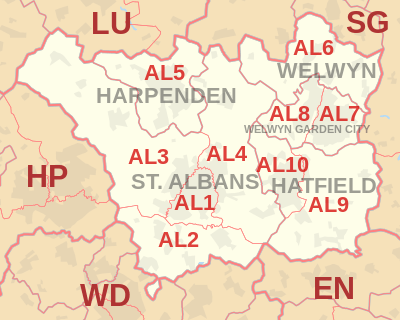
The approximate coverage of the postcode districts:
| Postcode district | Post town | Coverage | Local authority area |
|---|---|---|---|
| AL1 | ST ALBANS | St Albans | St Albans |
| AL2 | ST ALBANS | St Albans, Bricket Wood, Colney Street, Frogmore, London Colney, Napsbury, Park Street, Potters Crouch, Chiswell Green | St Albans, Hertsmere |
| AL3 | ST ALBANS | St Albans, Childwickbury, Flamstead, Gorhambury, Markyate, New Greens, Porters Wood, Redbourn, Sandridge | St Albans, Dacorum |
| AL4 | ST ALBANS | St Albans, Blackmore End, Colney Heath, London Colney, Jersey Farm, Marshalswick, Oaklands, Sandridge, Smallford, Tyttenhanger, Wheathampstead | St Albans, Hertsmere, North Hertfordshire |
| AL5 | HARPENDEN | Harpenden, Kinsbourne Green | St Albans |
| AL6 | WELWYN | Welwyn, Ayot St Peter, Ayot St Lawrence, Digswell, Rabley Heath, Tewin | Welwyn Hatfield, East Hertfordshire, North Hertfordshire |
| AL7 | WELWYN GARDEN CITY | Welwyn Garden City (east) | Welwyn Hatfield |
| AL8 | WELWYN GARDEN CITY | Welwyn Garden City (west), Lemsford | Welwyn Hatfield |
| AL9 | HATFIELD | Hatfield, Brookmans Park, Essendon, North Mymms | Welwyn Hatfield |
| AL10 | HATFIELD | Hatfield | Welwyn Hatfield |
Map
See also
References
- ↑ "ONS Postcode Directory Version Notes" (ZIP). National Statistics Postcode Products. Office for National Statistics. February 2012. Table 2. Retrieved 21 April 2012. Coordinates from mean of unit postcode points, "Code-Point Open". OS OpenData. Ordnance Survey. February 2012. Retrieved 21 April 2012.
- ↑ Royal Mail, Address Management Guide, (2004)
External links
This article is issued from Wikipedia - version of the 10/20/2016. The text is available under the Creative Commons Attribution/Share Alike but additional terms may apply for the media files.