LD postcode area
Postcode district boundaries: Bing / Google
| Llandrindod Wells postcode area | |
|---|---|
 LD | |
| Postcode area | LD |
| Postcode area name | Llandrindod Wells |
| Post towns | 8 |
| Postcode districts | 8 |
| Postcode sectors | 16 |
| Postcodes (live) | 2,203 |
| Postcodes (total) | 2,583 |
| Statistics as at February 2012[1] | |
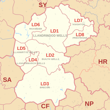
The LD postcode area, also known as the Llandrindod Wells postcode area,[2] is a group of eight postcode districts in Wales. These postcode districts cover much of south Powys, including Llandrindod Wells, Brecon, Builth Wells, Presteigne, Knighton, Rhayader, Llanwrtyd Wells and Llangammarch Wells. The LD7 and LD8 districts extend across the border into England, covering very small parts of Shropshire and Herefordshire.
The LD area covers a sparsely populated area and contains fewer postcodes than any other area on the British mainland, except for the KW area in the north-east of Scotland.[3]
Coverage
The approximate coverage of the postcode districts:
| Postcode district | Post town | Coverage | Local authority area |
|---|---|---|---|
| LD1 | LLANDRINDOD WELLS | Llandrindod Wells, Crossgates, Newbridge-on-Wye | Powys |
| LD2 | BUILTH WELLS | Builth Wells, Llanafan Fawr, Erwood | Powys |
| LD3 | BRECON | Brecon, Talgarth | Powys |
| LD4 | LLANGAMMARCH WELLS | Llangammarch Wells, Garth, Cefn Gorwydd | Powys |
| LD5 | LLANWRTYD WELLS | Llanwrtyd Wells, Beulah, Abergwesyn | Powys |
| LD6 | RHAYADER | Rhayader, St Harmon, Pant-Y-Dwr | Powys |
| LD7 | KNIGHTON | Knighton, Knucklas, Llangunllo, Llanfair Waterdine | Powys, Shropshire |
| LD8 | PRESTEIGNE | Presteigne, New Radnor, Norton, Stapleton | Powys, Herefordshire |
Map
See also
References
- ↑ "ONS Postcode Directory Version Notes" (ZIP). National Statistics Postcode Products. Office for National Statistics. February 2012. Table 2. Retrieved 21 April 2012. Coordinates from mean of unit postcode points, "Code-Point Open". OS OpenData. Ordnance Survey. February 2012. Retrieved 21 April 2012.
- ↑ Royal Mail, Address Management Guide, (2004)
- ↑ "National Statistics Postcode Directory" (PDF). Office for National Statistics Postcode Directory (November 2006). Office for National Statistics. November 2006. Retrieved 2009-05-29.
External links
- Royal Mail's Postcode Address File
- A quick introduction to Royal Mail's Postcode Address File (PAF)
- Using Welsh alternative addresses within Royal Mail's Postcode Address File (PAF)
This article is issued from Wikipedia - version of the 8/1/2016. The text is available under the Creative Commons Attribution/Share Alike but additional terms may apply for the media files.