ZE postcode area
Postcode district boundaries: Bing / Google
| Lerwick postcode area | |
|---|---|
 ZE | |
| Postcode area | ZE |
| Postcode area name | Lerwick |
| Post towns | 1 |
| Postcode districts | 3 |
| Postcode sectors | 4 |
| Postcodes (live) | 634 |
| Postcodes (total) | 724 |
| Statistics as at February 2012[1] | |
The ZE postcode area, also known as the Lerwick postcode area,[2] is a group of three postcode districts covering the Shetland Islands in Scotland. ZE is taken from Zetland, the name for the council area until 1975 and the traditional name for the Island group.
Coverage
The approximate coverage of the postcode districts:
| Postcode district | Post town | Coverage | Local authority area |
|---|---|---|---|
| ZE1 | SHETLAND | Lerwick, Scalloway | Shetland Islands Council |
| ZE2 | SHETLAND | Most of Mainland, Yell, Unst, Fetlar, Foula, Fair Isle | Shetland Islands Council |
| ZE3 | SHETLAND | Virkie | Shetland Islands Council |
Map
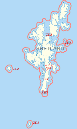
ZE postcode area map, showing postcode districts in red and the post town in grey text.
The KW postcode area is situated to the southwest.
See also
- Postcode Address File
- List of postcode areas in the United Kingdom
- Extreme points of the United Kingdom
References
- ↑ "ONS Postcode Directory Version Notes" (ZIP). National Statistics Postcode Products. Office for National Statistics. February 2012. Table 2. Retrieved 21 April 2012. Coordinates from mean of unit postcode points, "Code-Point Open". OS OpenData. Ordnance Survey. February 2012. Retrieved 21 April 2012.
- ↑ Royal Mail, Address Management Guide, (2004)
External List
This article is issued from Wikipedia - version of the 4/14/2016. The text is available under the Creative Commons Attribution/Share Alike but additional terms may apply for the media files.