Dhanbad
| Dhanbad धनबाद,دھنباد | |
|---|---|
| Metropolitan City | |
|
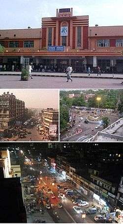
From top clockwise: Dhanbad Railway Station, Golchakkar, | |
| Nickname(s): 'The Coal Capital of India' , 'Koylanchal' . | |
 Dhanbad Location of Dhanbad in Jharkhand | |
| Coordinates: 23°48′N 86°27′E / 23.8°N 86.45°ECoordinates: 23°48′N 86°27′E / 23.8°N 86.45°E | |
| Country |
|
| State | Jharkhand |
| District | Dhanbad |
| Government | |
| • Body | Municipal corporation |
| • Mayor | Chandrashekhar Agarwal[1] |
| Area | |
| • Total | 2,052 km2 (792 sq mi) |
| Elevation | 222 m (728 ft) |
| Population (2011) | |
| • Total | 2,684,487 |
| • Rank | 42nd |
| • Density | 1,316/km2 (3,410/sq mi) |
| Languages | |
| • Official | Hindi, English, Urdu |
| Time zone | IST (UTC+5:30) |
| PIN | 826001 |
| Telephone code | +91-326 |
| Vehicle registration | JH 10 |
| Website |
www |
Dhanbad is a city in the Indian state of Jharkhand, India.[2] It is the second most populated city in Jharkhand.[3] Dhanbad along with its urban areas population ranks 42nd in population amongst other cities in India.
Dhanbad is famous for its coal mining, has some of the largest mines in India[4] and is called Coal Capital of India.[5] Tata Steel, Bharat Coking Coal Limited (BCCL), Eastern Coalfields Limited (ECL) and Indian Iron And Steel Company (IISCO) are some of the companies who operate coal mines in the district.[6][7][8] The IIT (ISM), Dhanbad is located in Dhanbad.
Among the rail divisions of Indian Railway, Dhanbad Rail Division is the second largest in terms of revenue generation after the Mumbai division.[9]
The city has one parliamentary seat and six seats in the Legislative Assembly.
Etymology
The Dhanbad originated from the district of Manbhum occupied by Mundari or Kolarian races in the wilderness of South undivided Bihar. In the seventh century A.D. some information is available from the account of the travels of Hieun Tsang. These accounts narrate existence of a powerful kingdom which comprised the district and adjoining areas, ruled by Sasanka.[10]
Manbhum was one of the districts of the East India during the British Raj. After India’s independence, the district became a part of Bihar state, and upon re-organization of the Indian states in the mid-1950s, the district became a part of the West Bengal. Present Purulia district was carved out of the district of Manbhum.[11]
Manbhum region has thick forests, with good mineral resources, and has a mixed demographic profile with people from different religious and social groups, including adivasis, particularly the Santals and the Mundas.[11]
Geography and climate
| Dhanbad | ||||||||||||||||||||||||||||||||||||||||||||||||||||||||||||
|---|---|---|---|---|---|---|---|---|---|---|---|---|---|---|---|---|---|---|---|---|---|---|---|---|---|---|---|---|---|---|---|---|---|---|---|---|---|---|---|---|---|---|---|---|---|---|---|---|---|---|---|---|---|---|---|---|---|---|---|---|
| Climate chart (explanation) | ||||||||||||||||||||||||||||||||||||||||||||||||||||||||||||
| ||||||||||||||||||||||||||||||||||||||||||||||||||||||||||||
| ||||||||||||||||||||||||||||||||||||||||||||||||||||||||||||
Dhanbad has an average elevation of 227 m (745 ft). Its geographical length (extending from north to south) is 15 miles (24 km) and the breadth (stretching across east to West) is 10 miles (16 km). It shares its boundaries with West Bengal in the eastern and southern part, Dumka and Giridih in the North and Bokaro in the west. Dhanbad comes under the Chota Nagpur Plateau.
Dhanbad features climate that is transitional between a humid subtropical climate and a tropical wet and dry climate. Summer starts from last week of March and ends in mid-June. Peak temperature in summer can reach 48 °C. Dhanbad also receives heavy rainfall. In winter, the minimum temperature remains around 10 °C with a maximum of 22 °C. Damodar River is the main river flowing through the district. Katri, Jamunia, Gobai, Khudia and Irji are the other rivers flowing through the district.
| Climate data for Dhanbad | |||||||||||||
|---|---|---|---|---|---|---|---|---|---|---|---|---|---|
| Month | Jan | Feb | Mar | Apr | May | Jun | Jul | Aug | Sep | Oct | Nov | Dec | Year |
| Average high °C (°F) | 25 (77) |
28 (82) |
33 (91) |
38 (100) |
39 (102) |
35 (95) |
31 (88) |
31 (88) |
31 (88) |
31 (88) |
28 (82) |
25 (77) |
31.3 (88.2) |
| Average low °C (°F) | 11 (52) |
14 (57) |
18 (64) |
23 (73) |
25 (77) |
25 (77) |
24 (75) |
24 (75) |
23 (73) |
20 (68) |
16 (61) |
11 (52) |
19.5 (67) |
| Average precipitation mm (inches) | 17 (0.67) |
18 (0.71) |
18 (0.71) |
22 (0.87) |
49 (1.93) |
192 (7.56) |
342 (13.46) |
311 (12.24) |
282 (11.1) |
105 (4.13) |
7 (0.28) |
5 (0.2) |
1,368 (53.86) |
| Source: IMD | |||||||||||||
History
The present district used to be a part of Manbhum. In the Settlement Report for Manbhum (1928) it was stated that no rock inscriptions, copper plates or old coins were discovered and not a single document of copper plate or palm leaf was found, during the Survey and Settlement operations. The oldest authentic documents produced were all on paper and barely even a hundred years old.[12] Dhanbad was in Manbhum district from 1928 up to 1956.[12]
Demography
As of 2011 India provisional census[13] Dhanbad had a population of 2,684,487. Males (1,405,956 ) constitute 53% of the population and females (1,278,531 ) 47%. It has a sex ratio of 908. Dhanbad has an average literacy rate of 80.78%, higher than the national average of 74.04%: male literacy is 87.93% and female literacy is 72.69%.[14] In Dhanbad, 10.57% of the population is under 5 years of age.
Religion
Hinduism is the dominant religion and Islam is the second largest religion in Dhanbad. As of the 2011 census, the population of Dhanbad is as follows.[15]
| Religion | Total | Percentage |
|---|---|---|
| Hindu | 2,149,480 | 80.07% |
| Muslims | 431,762 | 16.08% |
| Christian | 11,243 | 0.42% |
| Sikh | 9,727 | 0.36% |
| Buddhist | 331 | 0.01% |
| Jain | 1,268 | 0.05% |
| Not Stated | 3,494 | 0.13% |
| Others | 77,182 | 2.88% |
Government and PSU organisations
Though managed by a municipal corporation, Dhanbad was listed the least cleanest of all according to the latest Swachh Sarvekshan of 73 Indian cities in 2016.[16] Indian School of Mines (ISM) launched Total Waste Solution, or ToWaSo, a waste management start-up.[17] Taking note of the rising pollution in the coal city, the Municipal Corporation of Dhanbad (MCD) is plannng to plant trees which can absorb toxic gases from the atmosphere.[18]
Education
Universities and colleges
- Indian Institute of Technology (Indian School of Mines), Dhanbad
- Birsa Institute of Technology, Sindri
- Guru Nanak College[19]
- Law College of Dhanbad[20]
- Patliputra Medical College and Hospital[19]
- Raja Shiva Prasad College
Jharkhand chief minister Raghubar Das announced the setting up of a university in Dhanbad named after the legendary Binod Behari Mahto, a pioneer of the Jharkhand statehood movement and a JMM founder-member. The new university is also expected to serve the higher education needs of students of Bokaro and Giridih.[21] Vinoba Bhave University (VBU) has zeroed in on vacant land inside the premises of RS More College in Govindpur, Dhanbad, for setting up of the proposed Vinod Bihari Mahto Koylanchal University.[22]
Schools
- DAV Public School, Koyla Nagar / D.A.V Public School, Mahuda/ Moonidih/Alkusa/Putki/ /Baniahir (Lodna)/Barora/Dari Muhalla/CFRI (Digwadih)/Lodna/Moonidih/Purana/Sijua/Kusunda
- Tata D.A.V School, Jamadoba
- Delhi Public School, Dhanbad
- Carmel School Digwadih
- De Nobili School, FRI
- Jharia Raj High School
- Jharia Gujarati Hindi High School
Transport
Rail

Dhanbad Rail Division comes under East Central Railway zone. Grand Chord rail-line passes through Dhanbad junction, it connects Howrah and New Delhi. CIC rail line starts from Dhanbad and ends at Singrauli in Madhya Pradesh. There is one more rail line passing through the district, it starts at Kharagpur and ends at Gomoh, this rail line comes under South Eastern Railway. Dhanbad is connected with almost all states through rail network.
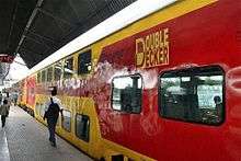
On 1 October 2011, India's first AC double-decker train was flagged off to connect Howrah and Dhanbad.[23][24][25][26]
Roads
National Highway 19 and National Highway 18 are the major highways passing through Dhanbad.[27] previously NH 2 now NH 19 and also AH1 is part of Golden Quadrilateral (GQ) highway network; Dhanbad lies in Kolkata-Delhi link of the Golden Quadrilateral network.[28] previously NH2 now NH19 is being converted into six lane expressway;previously NH 32 now NH 18 connects Dhanbad to Bokaro, Purulia and Jamshedpur. Private and State buses are available for inter-city travelling.[28]
Air
Dhanbad Airport is used for private small aircraft and helicopters, currently there is no public air-link at the airport. The nearest public airports to Dhanbad are[29]
Politics
Chandra Shekhar Agrawal is the mayor, otherwise known as the first citizen, of Dhanbad Municipal Corporation. He won by the margin of 42,525 votes.[30][31][32]
Raj Sinha of BJP won in the 40-Dhanbad assembly constituency defeating Mannan Malick of Congress in 2014.[33] Pashupati Nath Singh of BJP defeated Mannan Mallik of Congress in 2005, Prasadi Sao of RJD in 2000, and Ramadhar Yadav of JD in 1995. Surendra Prasad Roy of Congress defeated S.K. Shriva of JD in 1990 and Ram Chander Singh of Janata Party in 1985. Yogeshwar Prasad Yogesh of Congress defeated Gopi Kant Bakshi of CPI(M) in 1980 and Kalawati Devi of Janata Party.[34][35]
Dhanbad assembly constituency is part of Dhanbad (Lok Sabha constituency).[36]
Sports
Cricket is the most popular sport in Dhanbad, followed by Football. Dhanbad is one of the centres where 34th National Games[37] was organised. Cricket Stadiums at present are at Tata Steel Stadium Digwadih, Nehru Stadium Jealgora and Railway Stadium where Ranji Trophy matches are organised. Women's International Cricket were also played at Railway Stadium. Football matches of national level were played at Railway Stadium but now it is converted into Cricket Stadium by the Railway management and Sijua Stadium.
Dhanbad officially became the second town in the state to boast a cricket stadium with floodlights, with the inauguration of floodlights at Tata Digwadih Stadium.[38]
People from Dhanbad
- Anurag Dikshit - born in Dhanbad, ranked 207th richest person in the world by Forbes in 2006.[39]
- Deven Sharma, former Global President of Standard & Poor's
- Meenakshi Seshadri, Bollywood Actress
- Meiyang Chаng, Bollywood Actor
- Zeishan Quadri, Bollywood Actor, Film Maker
- Madhurima Tuli, Bollywood and South Indian Actress
- Shiv Khera, Author and Professional Speaker
References
- ↑ "Chandrashekhar is Dhanbad Mayor". Daily Pioneer. 30 May 2015.
- ↑ Eleven Indian cities among 100 fastest growing cities in the world. Merinews.com. Retrieved on 2012-04-14.
- ↑ Census- Jharkhand
- ↑ "Racketeering in coal: 'Coal crisis' in India presents a highly confusing picture : Cover Story - India Today". India Today. 18 February 2015.
- ↑ "The Sad State of India's Coal Capital". Wall Street Journal. 5 April 2010.
- ↑ "List of Coal Mines:Dhanbad District Of Jharkhand". dhanbad.nic.in.
- ↑ "Coal mines bleed in job mafia wars". The Telegraph. 9 April 2015.
- ↑ "Pollution choking Dhanbad as coal companies flout rules". Times of India. 9 August 2013.
- ↑ "Dhanbad Rail Division OVERVIEW". The Telegraph. Calcutta, India. 4 April 2012. Retrieved 10 October 2013.
- ↑ "DHANBAD DISTRICT OVERVIEW". Archived from the original on 17 March 2011. Retrieved 6 October 2011.
- 1 2 Encyclopædia Britannica, Eleventh Edition, a publication now in the public domain
- 1 2 Dhanbad Introduction/Jharkhand-Dhanbad Sightseeing-Dhanbad Jharkhand Transport-Places of Interest in Dhanbad. Indiatravelite.com. Retrieved on 2012-04-14.
- ↑ "Jharkhand Provisional Result-Census 2011" (PDF). Censusindia,gov,in. Census India. Retrieved 1 October 2011.
- ↑ Provisional 2011 Results. censusindia.gov.in
- ↑ http://www.census2011.co.in/census/district/96-dhanbad.html
- ↑ "Dhanbad among 10 least clean cities". zeenews.india.com.
- ↑ "ISM techies vow to clean up Dhanbad". timesofindia.indiatimes.com.
- ↑ "Green belt to fight pollution in Dhanbad". timesofindia.indiatimes.com.
- 1 2 http://dhanbad.nic.in/Education/colleges.html
- ↑ "Welcome to Law College Dhanbad". Retrieved 28 July 2015.
- ↑ "CM Das moots varsity tribute". telegraphindia.com.
- ↑ "Dhanbad land for new varsity". telegraphindia.com.
- ↑ "Double-decker train to run from howrah". Deccan Chronicle. 1 October 2011. Retrieved 2 October 2011.
- ↑ Kanwar, Disha (2 October 2011). "First AC double-decker train flagged off from Bengal". Business Standard. Retrieved 2 October 2011.
- ↑ "India's first AC double-decker train flagged off". Videos News. The Times of India. Retrieved 2 October 2011.
- ↑ "Double decker train frequency increased". Business Line. 2 January 2012.
- ↑ National Highways and their Length National Highway Authority of India (NHAI)
- 1 2 The Public Website of Dhanbad (Black Diamond City of India). dhanbad.jharkhand.org.in. Retrieved on 2015-08-15.
- ↑ "Dhanbad Railway Station". onefivenine.com. Retrieved 31 March 2012.
- ↑ http://www.telegraphindia.com/1150530/jsp/jharkhand/story_22836.jsp#.ViYs_vmqqko
- ↑ http://www.dailypioneer.com/state-editions/ranchi/chandrashekhar-is-dhanbad-mayor.html
- ↑ https://www.facebook.com/chandrashekharagrawaldhanbad/
- ↑ "Jharkhand State Election Results 2009". Travel India Guide. Retrieved 2010-04-09.
- ↑ "State Elections 2006 – Partywise Comparison for 40-Dhanbad assembly constituency of Jharkhand". Election Commission of India. Retrieved 2010-04-09.
- ↑ "State Elections 2006 – Partywise Comparison for 40-Dhanbad assembly constituency of Jharkhand". Election Commission of India. Retrieved 2010-04-09.
- ↑ "Dhanbad Loksabha Constituency (Jharkhand)". India Study Channel.com. Retrieved 2010-04-09.
- ↑ COMPUTER Ed. "Official website for the 34th National Games 2009, Jharkhand - Ranchi - Jamshedpur - Dhanbad - India". Archived from the original on 24 September 2010. Retrieved 28 July 2015.
- ↑ "Glowing Dhanbad stadium". telegraphindia.com.
- ↑ http://www.forbes.com/lists/2006/10/7XUE.html
External links
| Wikimedia Commons has media related to Dhanbad. |
| Wikivoyage has a travel guide for Dhanbad. |