Southern Mallee District Council
| Southern Mallee District Council South Australia | |||||||||||||
|---|---|---|---|---|---|---|---|---|---|---|---|---|---|
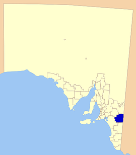
 The position of Southern Mallee District Council in SA. | |||||||||||||
| Population | 2,058 (2015 est)[1] | ||||||||||||
| • Density | 0.343/km2 (0.89/sq mi) | ||||||||||||
| Established | 1 July 1997 | ||||||||||||
| Area | 6,000 km2 (2,316.6 sq mi) | ||||||||||||
| Mayor | Andrew Grieger [2] | ||||||||||||
| Region | Murray and Mallee [3] | ||||||||||||
| State electorate(s) | Chaffey | ||||||||||||
| Federal Division(s) | Barker | ||||||||||||
 | |||||||||||||
| Website | Southern Mallee District Council | ||||||||||||
| |||||||||||||
The Southern Mallee District Council is a local government area in the Murray Mallee region of South Australia. The council offices are in Pinnaroo and Lameroo.[4] It was established on 1 July 1997 when the District Council of Lameroo and District Council of Pinnaroo agreed to merge. Their predecessors date from 1908.[5]
The largest towns are Lameroo and Pinnaroo; the council also includes the localities of Geranium, Karte, Parilla and Parrakie, and parts of Jabuk and Ngarkat.[6]
Council
| Ward | Councillor | Notes | |
|---|---|---|---|
| Kelly Scales [2] | Dennis Hyde | ||
| Stacey Milde | |||
| Bruce Summerton | |||
| Mark White | |||
| Bews [2] | Allan Dunsford | ||
| Andrew Grieger | Mayor | ||
| Neville Pfeiffer | Deputy Mayor | ||
| Robert Sexton | |||
| Brian Toogood | |||
References
- ↑ "3218.0 – Regional Population Growth, Australia, 2014–15". Australian Bureau of Statistics. Retrieved 29 September 2016.
- 1 2 3 "Councillors". Southern Mallee District Council. Retrieved 1 April 2016.
- ↑ "Murray and Mallee SA Government region" (PDF). The Government of South Australia. Retrieved 10 October 2014.
- ↑ "District Offices". Southern Mallee District Council. 2005-03-15. Retrieved 2007-04-09.
- ↑ "District History". Southern Mallee District Council. 11 May 2009. Retrieved 3 February 2016.
- ↑ "Location SA Map Viewer". Government of South Australia. Retrieved 1 April 2016.
External links
Coordinates: 35°15′36″S 140°54′31″E / 35.26°S 140.908611°E
This article is issued from Wikipedia - version of the 12/4/2016. The text is available under the Creative Commons Attribution/Share Alike but additional terms may apply for the media files.