Downingtown, Pennsylvania
| Borough of Downingtown | |
| Borough | |
 | |
| Country | United States |
|---|---|
| State | Pennsylvania |
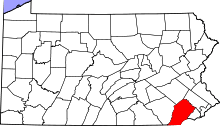
| County | Chester |
| Elevation | 239 ft (72.8 m) |
| Coordinates | 40°00′40″N 75°42′19″W / 40.01111°N 75.70528°WCoordinates: 40°00′40″N 75°42′19″W / 40.01111°N 75.70528°W |
| Area | 2.2 sq mi (5.7 km2) |
| - land | 2.2 sq mi (6 km2) |
| - water | 0.0 sq mi (0 km2), 0% |
| Population | 7,891 (2010) |
| Density | 3,586.8/sq mi (1,384.9/km2) |
| Incorporated | May 12, 1859 |
| Mayor | Josh Maxwell (D) |
| Timezone | EST (UTC-5) |
| - summer (DST) | EDT (UTC-4) |
| ZIP codes | 19335, 19372 |
| Area code | 610, 484 |
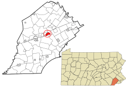 Location in Chester County and the state of Pennsylvania. | |
.svg.png) Location of Pennsylvania in the United States | |
| Website: http://www.downingtown.org | |
Downingtown is a borough in Chester County, Pennsylvania, 33 miles (53 km) west of Philadelphia. As of the 2010 census it had a population of 7,891. Downingtown was settled by English and European colonists in the early 18th century and has a number of historic buildings and structures.
History
The town was originally named Milltown due to its number of mills along the East Branch Brandywine Creek, the first of which was founded by Daniel Butter. The Butter family also had paper mills in the area, and Frederick Bicking from Winterburg, Germany, was the patriarch of the Bicking paper families. Around the time of the American Revolution, Milltown became more commonly known as Downingtown after the prominent businessman Thomas Downing,[1] a Quaker immigrant in 1717 from Bradninch, Devon, England, who owned a number of those mills. The town was officially named Downingtown in 1812.
The town is located along the Lincoln Highway (now part of U.S. Route 30) which runs from the East Coast to the West Coast. It was an early westward road in the wagon days as the Philadelphia and Lancaster Turnpike. The Lincoln Highway was the first paved road to cross the nation from the Atlantic to the Pacific. Construction of the Pennsylvania Turnpike started in the early 1940s and was completed in the early 1950s; it runs north of US 30, bypassing Downingtown.
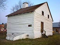
About 1705 Sami Warren built what has become known as the Downingtown Log House. In 1713 the next owner Hickman sold the 1½ story, 21' 9"×25' structure to Thomas and Mary Moore. Thomas Moore moved from the Log House in 1729 and died in 1738.
Thomas Downing acquired the Log House in 1739. It remained in the Downing family until 1940, when Thomas W. Downing died and left it to the borough of Downingtown. The borough did some restoration work to the Downingtown Log House in 1947. It served as the home to the Downingtown Chamber of Commerce from 1950 until 1988. But the Log House was deteriorating as Route 30 had been built close to it. Located 18 inches (46 cm) below street level, the house suffered water damage due to runoff from Route 30 and vibration from traffic weakened the structure.
From 1988 until 1990 the Downingtown Historical Society relocated the house and did an extensive restoration with money raised for the project. It now sits approximately 70 feet (21 m) west of its original location, 22 feet (6.7 m) from the Route 30 sidewalk, and slightly above street level.[2]
In 1904 John S. Trower and William A. Creditt, prominent black Philadelphians, founded the Downingtown Industrial and Agricultural School (DIAS) in Downingtown, to serve as an academic and vocational high school for African-American youths to prepare them for work.[3] Creditt was pastor of the First African Baptist Church in Philadelphia, and Trower, a successful caterer and one of the wealthiest black businessmen in the nation,[4] was a member of his congregation.[3] Believing the North needed a school like the Tuskegee Institute, the men found land in Chester County and built the school on a 100-acre campus.[3] They both served as principals until their respective deaths in 1921 (Creditt) and 1921.[3] Originally a private, non-denominational school, in 1907 DIAS began to be state supported. Students were admitted from major northeastern cities.[3] Among its trustees in the early decades was Adam Clayton Powell, Sr., pastor of Abyssinian Baptist Church in Harlem, New York.[5] The school operated until 1993. A new facility was constructed on the property and opened in 2002 as the Chester County campus of the Delaware County Community College.
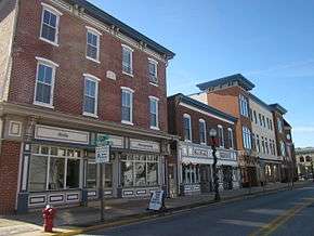
The city has initiated some widespread and continuing renovation in downtown, particularly to the streetscape; private owners have similarly renovated many commercial buildings. There has also been residential development on recovered industrial lands (brown fields) in the southeastern part of the borough. Downingtown is the location of some large regional and national businesses, including DNB (Downingtown National Bank), First National Bank of Chester County, and Victory Brewing Company. In 1988, a stall in its farmer's market was the first place where pretzels were sold by the founders of Auntie Anne's, now a global company with 1,000 stores and $375 million in annual sales.[6]
President Lincoln's funeral train passed through Downingtown. The famous Irish patriot and martyr Wolfe Tone briefly lived here.
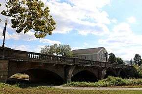
The County Bridge No. 124, Downingtown Log House, East Lancaster Avenue Historic District, General Washington Inn, and Roger Hunt Mill are listed on the National Register of Historic Places.[7]
In popular culture
- The 1958 movie, The Blob, was filmed in and around Downingtown. The diner featured in the movie, then called the "Downingtown Diner", was sold and transported to another state and has been replaced with a similar 50's style diner. Continuing to be advertised as the "home of the Blob," it has changed ownership numerous times over the years but is still open as of 2016.
Geography
Downingtown is located at 40°0′23″N 75°42′22″W / 40.00639°N 75.70611°W (40.006406, −75.706239).[8]
According to the United States Census Bureau, the borough has a total area of 2.2 square miles (5.7 km2), all of it land.
Demographics
| Historical population | |||
|---|---|---|---|
| Census | Pop. | %± | |
| 1860 | 761 | — | |
| 1870 | 1,077 | 41.5% | |
| 1880 | 1,480 | 37.4% | |
| 1890 | 1,920 | 29.7% | |
| 1900 | 2,133 | 11.1% | |
| 1910 | 3,326 | 55.9% | |
| 1920 | 4,024 | 21.0% | |
| 1930 | 4,548 | 13.0% | |
| 1940 | 4,645 | 2.1% | |
| 1950 | 4,948 | 6.5% | |
| 1960 | 5,598 | 13.1% | |
| 1970 | 7,437 | 32.9% | |
| 1980 | 7,650 | 2.9% | |
| 1990 | 7,749 | 1.3% | |
| 2000 | 7,589 | −2.1% | |
| 2010 | 7,891 | 4.0% | |
| Est. 2015 | 7,946 | [9] | 0.7% |
| Sources:[10][11][12] | |||
At the 2010 census, the borough was 76.0% non-Hispanic White, 12.0% Black or African American, 0.1% Native American, 2.7% Asian, 0.1% Native Hawaiian or other Pacific Islander, and 3.2% were two or more races. 7.2% of the population were of Hispanic or Latino ancestry.[13]
As of the census[11] of 2000, there were 7,589 people, 3,059 households, and 1,853 families residing in the borough. The population density was 3,473.2 people per square mile (1,338.0/km²). There were 3,197 housing units at an average density of 1,463.2 per square mile (563.6/km²). The racial makeup of the borough was 83.65% White, 10.79% African American, 0.12% Native American, 2.29% Asian, 0.04% Pacific Islander, 1.44% from other races, and 1.67% from two or more races. Hispanic or Latino of any race were 3.53% of the population.
Downingtown has a large population of residents that have Italian ancestry. The town has two different Italian American organizations and is listed as one of the Italian-American strongholds in the U.S.
There are 3,059 households, out of which 31.4% have children under the age of 18 living with them, 42.8% were married couples living together, 12.9% had a female householder with no husband present, and 39.4% were non-families. 32.2% of all households were made up of individuals, and 11.2% had someone living alone who was 65 years of age or older. The average household size was 2.40 and the average family size was 3.09.
The borough's population is spread out, with 25.3% under the age of 18, 8.7% from 18 to 24, 32.6% from 25 to 44, 19.2% from 45 to 64, and 14.1% who were 65 years of age or older. The median age was 35 years. For every 100 females there were 89.9 males. For every 100 females age 18 and over, there were 87.4 males.
The median income for a household in the borough was $45,979, and the median income for a family was $53,468. Males had a median income of $38,893 versus $29,284 for females. The per capita income for the borough was $21,634. About 3.0% of families and 4.8% of the population were below the poverty line, including 5.2% of those under age 18 and 5.3% of those age 65 or over.
Climate
According to the Köppen Climate Classification system, Downingtown has a humid subtropical climate, abbreviated "Cfa" on climate maps.[14]
| Climate data for Downingtown, Pennsylvania | |||||||||||||
|---|---|---|---|---|---|---|---|---|---|---|---|---|---|
| Month | Jan | Feb | Mar | Apr | May | Jun | Jul | Aug | Sep | Oct | Nov | Dec | Year |
| Average high °C (°F) | 11 (51) |
16 (60) |
17 (62) |
22 (71) |
24 (75) |
30 (86) |
33 (91) |
32 (89) |
26 (78) |
21 (69) |
16 (61) |
15 (59) |
22 (71) |
| Average low °C (°F) | 9 (48) |
9 (48) |
3 (38) |
4 (39) |
9 (49) |
20 (68) |
17 (63) |
16 (61) |
12 (54) |
6 (42) |
1 (33) |
−4 (24) |
11 (51) |
| Average precipitation mm (inches) | 91 (3.6) |
84 (3.3) |
97 (3.8) |
94 (3.7) |
99 (3.9) |
114 (4.5) |
112 (4.4) |
114 (4.5) |
94 (3.7) |
84 (3.3) |
84 (3.3) |
97 (3.8) |
1,163 (45.8) |
| Source: Weatherbase [15] | |||||||||||||
Education
Public education
- Beaver Creek Elementary School
- Bradford Heights Elementary School
- Brandywine Wallace Elementary School
- Downingtown Middle School
- Downingtown High School East Campus
- Downingtown High School West Campus
- Downingtown S.T.E.M. Academy
- East Ward Elementary School
- Lionville Elementary School
- Lionville Middle School
- Pickering Valley Elementary School
- Shamona Creek Elementary School
- Springton Manor Elementary School
- Uwchlan Hills Elementary School
- West Bradford Elementary School
- Marsh Creek Sixth Grade Center
Other schools
- Archdiocese of Philadelphia
- Bishop Shanahan High School
- St. Joseph's Parish School (K-8)
- St. Elizabeth Parish School (K-8)
- Chester County Intermediate Unit houses several offices and special services in Downingtown.
- Delaware County Community College, Brandywine Campus
Infrastructure
Roads
 US 30 (Downingtown Coatesville Bypass)
 US 30 Bus. (Lancaster Avenue/Lincoln Highway)
 US 322 (Manor Avenue/Brandywine Avenue)
 PA 113 (Uwchlan Avenue)
 PA 282 (Wallace Avenue)
Transit
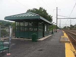
Downingtown station is located along the Lincoln Highway and is served by both SEPTA and Amtrak. The town is also served by the regional Rover bus service, operated by Krapf bus lines and functionally an extension of the SEPTA bus system throughout Chester County. Both systems provide access to Philadelphia and other suburbs along the Main Line through the SEPTA and AMTRAK train services.
References
- ↑ Gannett, Henry (1905). The Origin of Certain Place Names in the United States. Govt. Print. Off. p. 108.
- ↑ "Log House", Downington Historical Society
- 1 2 3 4 5 "Background Note", Downington Industrial and Agricultural School Collection,, Charles F. Blockson Afro-American Collection, Temple University Libraries
- ↑ "John S. Trower Best Known and Probably Wealthiest Negro in the Country", America’s Historical Newspapers, The Washington Bee, 29 April 1911. Web. 6 Feb. 2011
- ↑ Mather, Frank Lincoln. Who's Who of the Colored Race: A General Biographical Dictionary of Men and Women of African Descent, Vol. 1, Chicago: Memento Edition, 1915, p. 222
- ↑ "Auntie Anne's Pretzels", Lancaster Online
- ↑ National Park Service (2010-07-09). "National Register Information System". National Register of Historic Places. National Park Service.
- ↑ "US Gazetteer files: 2010, 2000, and 1990". United States Census Bureau. 2011-02-12. Retrieved 2011-04-23.
- ↑ "Annual Estimates of the Resident Population for Incorporated Places: April 1, 2010 to July 1, 2015". Retrieved July 2, 2016.
- ↑ "Census of Population and Housing". U.S. Census Bureau. Retrieved 11 December 2013.
- 1 2 "American FactFinder". United States Census Bureau. Retrieved 2008-01-31.
- ↑ "Incorporated Places and Minor Civil Divisions Datasets: Subcounty Resident Population Estimates: April 1, 2010 to July 1, 2012". Population Estimates. U.S. Census Bureau. Retrieved 11 December 2013.
- ↑ http://www.usatoday.com/news/nation/census/profile/PA
- ↑ Climate Summary for Downingtown, Pennsylvania
- ↑ "Weatherbase.com". Weatherbase. 2013. Retrieved on October 24, 2013.
External links
| Wikimedia Commons has media related to Downingtown, Pennsylvania. |
| Wikivoyage has a travel guide for Downingtown (Pennsylvania). |
- Borough of Downingtown official website
- Downingtown Friends Meeting website
- Pennsylvania Craft Brewery - Victory Brewing Company's
- St. James' Episcopal Church - Founded in 1843
- SEPTA
 |
|
| ||
| |
|
| ||
| ||||
| | ||||
| |