Dunseith, North Dakota
| Dunseith, North Dakota | |
|---|---|
| City | |
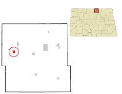 Location of Dunseith, North Dakota | |
| Coordinates: 48°48′49″N 100°3′42″W / 48.81361°N 100.06167°WCoordinates: 48°48′49″N 100°3′42″W / 48.81361°N 100.06167°W | |
| Country | United States |
| State | North Dakota |
| County | Rolette |
| Named for | Jeannette Dunseith Eaton |
| Area[1] | |
| • Total | 1.00 sq mi (2.59 km2) |
| • Land | 1.00 sq mi (2.59 km2) |
| • Water | 0 sq mi (0 km2) |
| Elevation | 1,706 ft (520 m) |
| Population (2010)[2] | |
| • Total | 773 |
| • Estimate (2015)[3] | 797 |
| • Density | 773.0/sq mi (298.5/km2) |
| Time zone | Central (CST) (UTC-6) |
| • Summer (DST) | CDT (UTC-5) |
| ZIP code | 58329 |
| Area code(s) | 701 |
| FIPS code | 38-21020 |
| GNIS feature ID | 1028750[4] |
Dunseith (/dʌnˈsiːθ/ dun-SEETH) is a city in Rolette County, North Dakota, United States. The population was 773 at the 2010 census.[5] Dunseith is best known for its proximity to the International Peace Garden. The port of entry at the Peace Garden is one of three 24-hour ports in North Dakota (the others being Portal and Pembina). Dunseith is also the home of the world's largest turtle sculpture, the "Wee'l Turtle", made of more than 2,000 wheels painted green.
History
Dunseith was platted in 1882.[6] The town is named for Jeannette Dunseith Eaton, who was the mother of the town's founder William Eaton. Dùnsìth is a Gaelic word meaning "City of Peace,"[7] from dùn (English: fortress) and sìth (English: peace).[8] A post office has been in operation in Dunseith since 1884.[9] The city was incorporated in 1908.[6]
Geography
According to the United States Census Bureau, the city has a total area of 1.00 square mile (2.59 km2), all of it land.[1] Dunseith lies just south of the Turtle Mountain plateau.
Demographics
| Historical population | |||
|---|---|---|---|
| Census | Pop. | %± | |
| 1910 | 473 | — | |
| 1920 | 374 | −20.9% | |
| 1930 | 484 | 29.4% | |
| 1940 | 719 | 48.6% | |
| 1950 | 713 | −0.8% | |
| 1960 | 1,017 | 42.6% | |
| 1970 | 811 | −20.3% | |
| 1980 | 625 | −22.9% | |
| 1990 | 723 | 15.7% | |
| 2000 | 739 | 2.2% | |
| 2010 | 773 | 4.6% | |
| Est. 2015 | 797 | [10] | 3.1% |
| U.S. Decennial Census[11] 2015 Estimate[3] | |||
2010 census
As of the census[2] of 2010, there were 773 people, 274 households, and 170 families residing in the city. The population density was 773.0 inhabitants per square mile (298.5/km2). There were 299 housing units at an average density of 299.0 per square mile (115.4/km2). The racial makeup of the city was 15.0% White, 0.9% African American, 79.6% Native American, 0.4% from other races, and 4.1% from two or more races. Hispanic or Latino of any race were 2.2% of the population.
There were 274 households of which 46.4% had children under the age of 18 living with them, 27.4% were married couples living together, 25.2% had a female householder with no husband present, 9.5% had a male householder with no wife present, and 38.0% were non-families. 32.1% of all households were made up of individuals and 12% had someone living alone who was 65 years of age or older. The average household size was 2.72 and the average family size was 3.41.
The median age in the city was 27.4 years. 35.8% of residents were under the age of 18; 10.2% were between the ages of 18 and 24; 23.7% were from 25 to 44; 18.2% were from 45 to 64; and 12.2% were 65 years of age or older. The gender makeup of the city was 49.2% male and 50.8% female.
2000 census
As of the census of 2000, there were 739 people, 253 households, and 178 families residing in the city. The population density was 729.2 people per square mile (282.5/km²). There were 282 housing units at an average density of 278.2 per square mile (107.8/km²). The racial makeup of the city was 24.76% White, 0.27% African American, 71.04% Native American, 0.14% Asian, 0.14% from other races, and 3.65% from two or more races. Hispanic or Latino of any race were 0.27% of the population.
There were 253 households out of which 44.3% had children under the age of 18 living with them, 31.6% were married couples living together, 32.4% had a female householder with no husband present, and 29.6% were non-families. 26.5% of all households were made up of individuals and 9.5% had someone living alone who was 65 years of age or older. The average household size was 2.74 and the average family size was 3.23.
In the city the population was spread out with 35.2% under the age of 18, 11.1% from 18 to 24, 23.8% from 25 to 44, 14.5% from 45 to 64, and 15.4% who were 65 years of age or older. The median age was 28 years. For every 100 females there were 90.5 males. For every 100 females age 18 and over, there were 80.1 males.
The median income for a household in the city was $17,917, and the median income for a family was $19,531. Males had a median income of $21,042 versus $20,250 for females. The per capita income for the city was $9,478. About 40.0% of families and 36.5% of the population were below the poverty line, including 48.7% of those under age 18 and 24.6% of those age 65 or over.
Climate
This climatic region is typified by large seasonal temperature differences, with warm to hot (and often humid) summers and cold (sometimes severely cold) winters. According to the Köppen Climate Classification system, Dunseith has a humid continental climate, abbreviated "Dfb" on climate maps.[12]
References
- 1 2 "US Gazetteer files 2010". United States Census Bureau. Retrieved 2012-06-14.
- 1 2 "American FactFinder". United States Census Bureau. Retrieved 2012-06-14.
- 1 2 "Population Estimates". United States Census Bureau. Retrieved June 24, 2016.
- ↑ "US Board on Geographic Names". United States Geological Survey. 2007-10-25. Retrieved 2008-01-31.
- ↑ "2010 Census Redistricting Data (Public Law 94-171) Summary File". American FactFinder. United States Census Bureau. Retrieved 2 May 2011.
- 1 2 "Explain Origin of All County Towns". Turtle Mountain Star. September 5, 1940. p. 7. Retrieved 2 May 2015.
- ↑ Wick, Douglas A. (1988). North Dakota Place Names. Bismarck, North Dakota: Hedemarken Collectibles. p. 52. ISBN 0-9620968-0-6. OCLC 191277027.
- ↑ "Scottish Gaelic dictionary". Lexiglos.com. 2009. Retrieved 2009-10-19.
- ↑ "Rolette County". Jim Forte Postal History. Retrieved 14 February 2015.
- ↑ "Annual Estimates of the Resident Population for Incorporated Places: April 1, 2010 to July 1, 2015". Retrieved July 2, 2016.
- ↑ United States Census Bureau. "Census of Population and Housing". Retrieved September 7, 2013.
- ↑ Climate Summary for Dunseith, North Dakota
Municipalities and communities of Rolette County, North Dakota, United States | ||
|---|---|---|
| Cities | 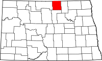 | |
| Townships |
| |
| CDPs | ||
| Unorganized territories |
| |
| Unincorporated communities | ||