Pembina, North Dakota
| Pembina, North Dakota | |
|---|---|
| City | |
|
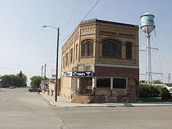
Building and water tower in Pembina | |
| Motto: "Oldest Settlement in the Dakota Territories" | |
 Location of Pembina, North Dakota | |
| Coordinates: 48°57′59″N 97°14′43″W / 48.96639°N 97.24528°WCoordinates: 48°57′59″N 97°14′43″W / 48.96639°N 97.24528°W | |
| Country | United States |
| State | North Dakota |
| County | Pembina |
| Area[1] | |
| • Total | 0.77 sq mi (1.99 km2) |
| • Land | 0.77 sq mi (1.99 km2) |
| • Water | 0 sq mi (0 km2) |
| Elevation | 778 ft (237 m) |
| Population (2010)[2] | |
| • Total | 592 |
| • Estimate (2015)[3] | 565 |
| • Density | 768.8/sq mi (296.8/km2) |
| Time zone | Central (CST) (UTC-6) |
| • Summer (DST) | CDT (UTC-5) |
| ZIP code | 58271 |
| Area code(s) | 701 |
| FIPS code | 38-61580 |
| GNIS feature ID | 1030666[4] |
Pembina ![]() i/ˈpɛmbᵻnə/ is a city in Pembina County, North Dakota, United States. The population was 592 at the 2010 census.[5] Pembina is located 2 miles (3.2 km) south of the Canada–US border. Interstate 29 passes on the west side of Pembina, leading north to the Canada–US border at Emerson, Manitoba and south to the cities of Grand Forks and Fargo. The Pembina-Emerson border crossing is the busiest between Blaine, Washington and Detroit, Michigan and the fifth busiest along the Canada-United States border. It is one of three 24-hour ports of entry in North Dakota, the others being Portal and Dunseith.[6] The Emerson-Noyes border crossing, located 2 miles (3.2 km) to the east on the Minnesota side of the Red River, also processed cross border traffic until its closure in 2006.
i/ˈpɛmbᵻnə/ is a city in Pembina County, North Dakota, United States. The population was 592 at the 2010 census.[5] Pembina is located 2 miles (3.2 km) south of the Canada–US border. Interstate 29 passes on the west side of Pembina, leading north to the Canada–US border at Emerson, Manitoba and south to the cities of Grand Forks and Fargo. The Pembina-Emerson border crossing is the busiest between Blaine, Washington and Detroit, Michigan and the fifth busiest along the Canada-United States border. It is one of three 24-hour ports of entry in North Dakota, the others being Portal and Dunseith.[6] The Emerson-Noyes border crossing, located 2 miles (3.2 km) to the east on the Minnesota side of the Red River, also processed cross border traffic until its closure in 2006.
The area of Pembina was long inhabited by various indigenous peoples. At the time of 16th century French exploration and fur trading, historical American Indian tribes included the Lakota (Sioux, as the French called them), the Chippewa (Ojibwe), and the Assiniboine. The British/Canadian Hudson's Bay Company established a fur-trading post on the site of present-day Pembina in 1797, and it is the oldest European-American community in the Dakotas.[7] The first permanent Anglo-Canadian settlement started in 1812.[7] Until 1823, both the United States (US) and Canada believed the community of Pembina was in Canadian territory. That year United States Army Major Stephen H. Long's survey of the 49th parallel revealed Pembina's location to be just south of the Canada – United States border.[8] In 1851, the US established its first post office in present-day North Dakota in Pembina.[9] Pembina was the most populous place in North Dakota according to the 1860 census. Pembina served as county seat from 1867 to 1911.
Pembina is home to the U.S. satellite plant of Motor Coach Industries, which completes assembly of intercity buses. Its major clients include Greyhound Lines.
Namesake
The name Pembina is an Ojibwa word for Viburnum edule, a bushy plant with bright red berries which grows in the area.[10]
History

The Pembina area was historically at the borders of the territories of the Lakota, the Chippewa, and the Assiniboine, American Indian tribes, who competed for hegemony. Their conflict increased beginning with the French introduction of firearms in the late 17th century as part of their goods traded for furs. The first known European visitors to the Pembina region were the French La Vérendrye family in the early 18th century.
Pembina's recorded history of European encounter extended for more than 200 years. Started by the French as a fur trading post for commerce with the American Indians, it was also tied to trade for American Bison. European trappers who hunted in the Red River of the North area frequently married Indian women and often lived with local tribes at least part of the year. Their mixed-race descendants became part of their hunting and trapping culture, and formed the later ethnic group recognized in Canada as Métis people.
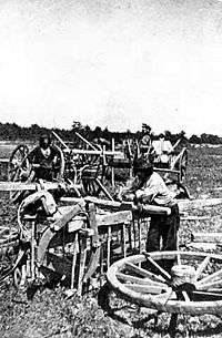
The settlement was associated with the histories of French Canada, the North West Company (NWC). the Hudson's Bay Company (HBC), the Red River Colony, Battle of Seven Oaks, the Red River Rebellion, Assiniboia, and Manitoba. Through much of the nineteenth century, Métis families used the two-wheeled Red River ox cart trains to travel into the Great Plains, where the men would hunt bison and women would process the meat, skins, and bones.[11] All parts were used for clothing, tepees, etc. Their regular trade routes became known as the Red River Trails. This area was part of the United States' Dakota and Minnesota territories; and Canada–US border politics.
Fort Pembina trading posts
- Peter Grant of the North West Company, between 1784 and 1789, built a post on the east side of the Red River. It had disappeared by 1801.[12]
- In 1797 Jean Baptiste Chaboillez of the North West Company built a post on the south bank of the Pembina in what is now Pembina State Park. In the same year David Thompson (explorer) determined that Pembina was south of the 49th parallel.
- From 1800 to 1805 the XY Company had a post within sight of the two following posts. It was absorbed by the North West Company.
- In 1801 Alexander Henry the younger, also of the North West Company, built a post on the north bank across from Chaboillez's post. He remained in charge until 1808. It was absorbed by the Hudson's Bay Company in 1821.
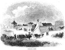
- By 1793 the Hudson's Bay Company had a small post (seemingly called Fort Skene[13]) on the east side on the Red River. It was rebuilt in 1801. By 1805 most of the local beaver had been exterminated. Pembina was the traditional rendezvous for the Métis buffalo hunt.[11] It was also a center for illicit trade with the United States. The HBC post operated until at least 1870, even though it was known to be south of the border.
- In 1812 Selkirk settlers from the Red River Colony built Fort Daer on the Chaboillez site.[14]
- In the 1840s Norman Kittson of the American Fur Company had an establishment.[15]
Fort Pembina
Due to the unrest among American Indians of the Red River Valley after the American Civil War, the Minnesota Legislature petitioned Congress to build a fort, especially to defend against incursions by the Lakota (Sioux), some of whom had migrated to Canada to evade the US Army.
As a result, Major General Winfield Scott Hancock recommended the establishment of the post on December 8, 1869; Fort Pembina was completed on July 8, 1870. Located a mile and a half south of the settlement, it was just above the mouth of the Pembina River. It was originally called Fort Thomas, for Major General George H. Thomas, who died on March 28, 1870. The post was designated Fort Pembina on September 6, 1870. Seriously damaged by fire on May 27, 1895, it was abandoned on August 16, 1895. It was later sold at public auction.[16]
Recent history
The noted American author Louise Erdrich has represented the Pembina River and the Pembina Band of the Ojibwe Indians on the Turtle Mountain Reservation in numerous works of fiction. In the past several books, the Pembina have celebrated their unique heritage.
Despite its small size, Pembina maintained a television station, KCND-TV, from 1960 to 1975. The station was a border blaster primarily targeting Winnipeg from as close to the border as possible; when simultaneous substitution rules took effect in the early 1970s, Canadian interests bought the intellectual property of the station and relocated it to Winnipeg, where it was relicensed by the Canadian government as CKND-TV and has operated there ever since.
Its population in federal censuses has not exceeded 1,000.
Geography
Pembina is located at 48°57′59″N 97°14′43″W / 48.96639°N 97.24528°W (48.966423, -97.245142),[17] in the far northeast corner of the North Dakota, at the confluence of the Red River of the North and the Pembina River. The city of St. Vincent, Minnesota lies adjacent to the east, across the Red River. The town of Emerson, Manitoba lies just north of the city on the other side of the international border.
According to the United States Census Bureau, the city has a total area of 0.77 square miles (1.99 km2), all of it land.[1]
Pembina experiences a humid continental climate (Köppen Dwb) with long, dry, very cold winters and very warm, wetter summers.
| Climate data for Pembina, North Dakota (1981-2010 Climate Normals) | |||||||||||||
|---|---|---|---|---|---|---|---|---|---|---|---|---|---|
| Month | Jan | Feb | Mar | Apr | May | Jun | Jul | Aug | Sep | Oct | Nov | Dec | Year |
| Average high °F (°C) | 12.6 (−10.8) |
18.3 (−7.6) |
31.1 (−0.5) |
50.9 (10.5) |
64.9 (18.3) |
73.8 (23.2) |
78.4 (25.8) |
77.8 (25.4) |
67.3 (19.6) |
51.8 (11) |
32.5 (0.3) |
17.5 (−8.1) |
48.08 (8.93) |
| Average low °F (°C) | −5.7 (−20.9) |
−0.8 (−18.2) |
13.5 (−10.3) |
29.3 (−1.5) |
41.4 (5.2) |
51.9 (11.1) |
56.0 (13.3) |
53.1 (11.7) |
43.0 (6.1) |
30.9 (−0.6) |
16.6 (−8.6) |
1.0 (−17.2) |
27.52 (−2.49) |
| Average precipitation inches (mm) | 0.46 (11.7) |
0.38 (9.7) |
0.79 (20.1) |
0.93 (23.6) |
2.96 (75.2) |
4.06 (103.1) |
3.10 (78.7) |
2.63 (66.8) |
2.15 (54.6) |
1.71 (43.4) |
0.96 (24.4) |
0.52 (13.2) |
20.65 (524.5) |
| Source: NOAA (normals, 1981–2010) [18] | |||||||||||||
Demographics

| Historical population | |||
|---|---|---|---|
| Census | Pop. | %± | |
| 1880 | 287 | — | |
| 1890 | 670 | 133.4% | |
| 1900 | 929 | 38.7% | |
| 1910 | 717 | −22.8% | |
| 1920 | 802 | 11.9% | |
| 1930 | 551 | −31.3% | |
| 1940 | 703 | 27.6% | |
| 1950 | 640 | −9.0% | |
| 1960 | 625 | −2.3% | |
| 1970 | 741 | 18.6% | |
| 1980 | 673 | −9.2% | |
| 1990 | 642 | −4.6% | |
| 2000 | 642 | 0.0% | |
| 2010 | 592 | −7.8% | |
| Est. 2015 | 565 | [19] | −4.6% |
| U.S. Decennial Census[20] 2015 Estimate[3] | |||
2010 census
As of the census[2] of 2010, there were 592 people, 237 households, and 156 families residing in the city. The population density was 768.8 inhabitants per square mile (296.8/km2). There were 279 housing units at an average density of 362.3 per square mile (139.9/km2). The racial makeup of the city was 94.1% White, 0.5% African American, 0.3% Native American, 1.0% Asian, 1.4% from other races, and 2.7% from two or more races. Hispanic or Latino of any race were 1.4% of the population.
There were 237 households of which 29.1% had children under the age of 18 living with them, 57.4% were married couples living together, 5.1% had a female householder with no husband present, 3.4% had a male householder with no wife present, and 34.2% were non-families. 30.8% of all households were made up of individuals and 10.1% had someone living alone who was 65 years of age or older. The average household size was 2.50 and the average family size was 3.17.
The median age in the city was 40.6 years. 26.2% of residents were under the age of 18; 6.4% were between the ages of 18 and 24; 23.4% were from 25 to 44; 29.9% were from 45 to 64; and 14.2% were 65 years of age or older. The gender makeup of the city was 48.3% male and 51.7% female.
2000 census
As of the census of 2000, there were 642 people, 250 households, and 177 families residing in the city. The population density was 843.1 people per square mile (326.2/km²). There were 274 housing units at an average density of 359.8 per square mile (139.2/km²). The racial makeup of the city was 96.57% White, 0.16% African American, 0.47% Native American, 0.47% Asian, 1.56% from other races, and 0.78% from two or more races. Hispanic or Latino of any race were 1.87% of the population.
There were 250 households out of which 35.2% had children under the age of 18 living with them, 62.8% were married couples living together, 5.2% had a female householder with no husband present, and 28.8% were non-families. 26.8% of all households were made up of individuals and 11.2% had someone living alone who was 65 years of age or older. The average household size was 2.57 and the average family size was 3.12.
In the city the population was spread out with 29.4% under the age of 18, 4.8% from 18 to 24, 29.0% from 25 to 44, 24.0% from 45 to 64, and 12.8% who were 65 years of age or older. The median age was 37 years. For every 100 females there were 98.8 males. For every 100 females age 18 and over, there were 105.0 males.
The median income for a household in the city was $55,536, and the median income for a family was $59,722. Males had a median income of $35,250 versus $26,125 for females. The per capita income for the city was $20,278. About 4.5% of families and 7.7% of the population were below the poverty line, including 12.1% of those under age 18 and 8.2% of those age 65 or over.
Sites of interest
- Pembina State Museum - interpretative exhibits commemorating establishment of Pembina in 1797 as the earliest European settlement in what is now the state of North Dakota.
- Pembina State Park - a protected area located at the confluence of the Red and Pembina Rivers.
- Fort Daer Landing And Recreation Area.
- Dumoulin Mission and Cemetery Site, located north of Pembina along north-bound Interstate 29.
See also
- Métis buffalo hunt
- Battle of Grand Coteau (North Dakota)
- List of Canada-United States border crossings
- Emerson, Manitoba
References
- 1 2 "US Gazetteer files 2010". United States Census Bureau. Retrieved 2012-06-14.
- 1 2 "American FactFinder". United States Census Bureau. Retrieved 2012-06-14.
- 1 2 "Population Estimates". United States Census Bureau. Retrieved June 26, 2016.
- ↑ "US Board on Geographic Names". United States Geological Survey. 2007-10-25. Retrieved 2008-01-31.
- ↑ "2010 Census Redistricting Data (Public Law 94-171) Summary File". American FactFinder. United States Census Bureau. Retrieved 2 May 2011.
- ↑ Behind the Scenes at the Pembina Port
- 1 2 History of Pembina - City of Pembina website
- ↑ "Where is Pembina?", Prairie Public Radio Website
- ↑ "Chronological history of North Dakota", State Historical Society
- ↑ Federal Writer's Project of the Works Progress Administration for the State of North Dakota (1977). The WPA Guide To 1930s North Dakota (2nd ed.). State Historical Society of North Dakota. p. 223. ISBN 1891419145.
- 1 2 George Bryce. The Remarkable History of the Hudson's Bay Company... Nabu Press. ISBN 978-1-277-72735-7.
- ↑ Francess G. Halpenny; Jean Hamelin (1 January 1988). Dictionary of Canadian Biography, 1836-1850. Springer Science & Business Media. p. 356. ISBN 978-0-8020-3452-6.
- ↑ Arthur Morton, "A History of the Canadian West", circa 1936, page 545
- ↑ "The ;Manitoba Historical Society (Fort Daer (Pembina, North Dakota))". Retrieved 2014-12-04.
- ↑ Elizabeth Browne Losey,"Let Them be Remembered:The Story of the Fur Trade Forts", 1999,pages 235-239
- ↑ Forts in the Dakota Territory, Frohne & Son Historic Military, Accessed December 8, 2010
- ↑ "US Gazetteer files: 2010, 2000, and 1990". United States Census Bureau. 2011-02-12. Retrieved 2011-04-23.
- ↑ "1981-2010 Normals Data Access". National Oceanic and Atmospheric Administration. Retrieved October 22, 2013.
- ↑ "Annual Estimates of the Resident Population for Incorporated Places: April 1, 2010 to July 1, 2015". Retrieved July 2, 2016.
- ↑ "U.S. Decennial Census". Census.gov. Retrieved May 29, 2013.
External links
- City of Pembina official website
- History of Pembina - city website
- Pioneer Women's Histories : Pembina from the Digital Horizons website
Municipalities and communities of Pembina County, North Dakota, United States | ||
|---|---|---|
| Cities | 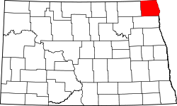 | |
| Townships |
| |
| Unincorporated communities | ||