Eluru
| Eluru ఏలూరు Ellore Helapuri | |
|---|---|
| City | |
|
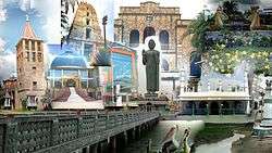
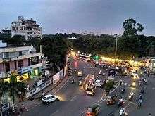
Topography of Eluru | |
 Eluru | |
| Coordinates: 16°42′N 81°06′E / 16.7°N 81.1°ECoordinates: 16°42′N 81°06′E / 16.7°N 81.1°E | |
| Country | India |
| State | Andhra Pradesh |
| District | West Godavari |
| Government | |
| • Type | Mayor-council |
| • Body | Eluru Municipal Corporation |
| • M.P | Maganti Venkateswara Rao |
| • M.L.A | Badeti Kota Ramarao |
| Area[1][2] | |
| • City | 11.52 km2 (4.45 sq mi) |
| Elevation | 22 m (72 ft) |
| Population (2011)[3] | |
| • City | 283,648 |
| • Rank | 6th (in state) |
| • Density | 25,000/km2 (64,000/sq mi) |
| • Metro[4] | 350,000[5][6] |
| Demonym(s) | Elurian |
| Languages | |
| • Official | Telugu |
| Time zone | IST (UTC+5:30) |
| PIN | 53400* |
| Telephone code | +91–8812 |
| Vehicle registration | AP–37 |
| Website |
eluru |
Eluru is a city and district headquarters of West Godavari district in the Indian state of Andhra Pradesh.[7] It is one of the 16 municipal corporations in the state, and the mandal headquarters of Eluru mandal in Eluru revenue division.[8][9] As of 2011 Census of India, the city had a population of 283,648.[3] The city is well known for its wool-pile carpets and hand woven products.[10]
Etymology
The city was alternately referred as in days of Buddhist kingdom of Vengi as Helapuri.[11] It was also known as Ellore.[12]
History
.jpg)
History of Eluru dates back to 2nd century and has great prominence in the history of Andhra. Vengi near Eluru was capital of Andhra from 2nd century to 12th century, ruled by Salankayanas, Vishnukudinas, and Eastern Chalukyas. Vengi was the capital city of Andhradesa for many years than any other city in Andhra Pradesh. Eluru was part of the Buddhist kingdom of Vengi.
Salankayanas (3rd century AD to 5th century):
Salankayana ruled from 3rd century AD to 5th century AD. They were known as Salankayana after the Gotra name. They were the feudatories of Ikshvakus. They Ruled near vengi area, with Vengi (Eluru) as the capital. Salankayana is another of the Phantom kingdoms of Andhra for Indologists. Their date is fixed based on Samudra Gupta inscription mention of Hastivarman of Vengi.[13]
Vishnukundina (5th century to 7th century):
Eluru was major city of Vishnukundinas.[14] Vishnukundin reign might be fixed between the end of the Salankayana and the rise of the Eastern Chalukyan power in 624 AD.[15] In the late 5th century, the Salankayanas were conquered by Madhavarma II of the Vishnukundinas. During the reign of Madhava Varma the Great, they became independent and conquered coastal Andhra from the Salankayanas and might have shifted their capital to a place in the Coastal Andhra.[16]
Eastern Chalukyas Period (7th century to 12th century):
Eastern Chalukyas, or Chalukyas of Vengi were a South Indian dynasty whose kingdom was located in the present day Andhra Pradesh. Their capital was Vengi near Eluru and their dynasty lasted for around 500 years from the 7th century until c. 1130 C.E. when the Vengi kingdom merged with the Chola empire. The Vengi kingdom was continued to be ruled by Eastern Chalukyan kings under the protection of the Chola empire until 1189 C.E., when the kingdom succumbed to the Hoysalas and the Yadavas. They had their capital originally at Vengi now (Pedavegi) near Eluru of the West Godavari district end later changed to Rajamahendravaram (Rajamundry).
Kakathiya, Kalinga, Vijayanagara, and Golkonda's Period (13th Century to 16th Century):
Eluru was later captured by Kakatiyas and then became a part of the Kalinga Empire until 1471. Later it fell into the hands of the Gajapatis. In 1515 Srikrishnadevaraya captured it. After the fall of the Vijayanagara Kingdom, it was taken by the Sultan of Golkonda, Kutub Shah. Mohammedans built the fort at Eluru from the ruins of Vengi.[17]
Modern History:
Eluru was formerly a military station, and the capital of the Northern Circars, a former division of British India's Madras Presidency.[12] Salabat Jang, the son of the Nizam al Mulk, granted Northern Circurs to French East India Company and was necessarily transferred from the French to the British. After the British established control over South India, Eluru and surrounding areas were merged into the Madras Presidency.
Eluru was a part of Machilipatnam district after the division of Northern Circars. In 1859, it was included in the Godavari district and later it was made a part of the Krishna district. In 1925, it became the headquarters of the newly formed West Godavari district.[18]
Geography
Eluru is located at 16°42′N 81°06′E / 16.7°N 81.1°E and has an average elevation of 22 m (72 ft). It lies on the Eastern coastal plains.[19] The Tammileru river, the Krishna and Godavari Canals passes through the city, before the river and the Eluru canal from Krishna empties into Kolleru Lake near the city.[18]
Climate
The city experiences hot and humid climate due to its close proximity from the shore of Bay of Bengal. It has an average annual temperature of 28.2 °C (82.8 °F). May is the hottest and December is the coolest month of the year. July receives most precipitation and annually the city receives an average rainfall of 992 mm (39.1 in).[20]
| Climate data for Eluru, Andhra Pradesh | |||||||||||||
|---|---|---|---|---|---|---|---|---|---|---|---|---|---|
| Month | Jan | Feb | Mar | Apr | May | Jun | Jul | Aug | Sep | Oct | Nov | Dec | Year |
| Average high °C (°F) | 29.1 (84.4) |
31.7 (89.1) |
34.5 (94.1) |
36.7 (98.1) |
38.6 (101.5) |
36.9 (98.4) |
32.4 (90.3) |
32.0 (89.6) |
32.2 (90) |
31.4 (88.5) |
29.8 (85.6) |
28.8 (83.8) |
32.84 (91.12) |
| Average low °C (°F) | 18.9 (66) |
20.3 (68.5) |
22.6 (72.7) |
25.8 (78.4) |
27.9 (82.2) |
27.2 (81) |
25.4 (77.7) |
25.3 (77.5) |
25.3 (77.5) |
24.3 (75.7) |
21.3 (70.3) |
18.8 (65.8) |
23.59 (74.44) |
| Average rainfall mm (inches) | 3 (0.12) |
6 (0.24) |
6 (0.24) |
14 (0.55) |
40 (1.57) |
123 (4.84) |
229 (9.02) |
186 (7.32) |
170 (6.69) |
166 (6.54) |
40 (1.57) |
9 (0.35) |
992 (39.05) |
| Source: en.climate-data.org | |||||||||||||
Demographics
As of 2011 census of India, Eluru had population of 283,648 of which 140,059 were male and 143,589 female.[22]The Eluru urban agglomeration had a population of 350,000.[23][24]
Governance
Civic administration

Eluru Municipal Corporation is the civic body of Eluru. It was first constituted as a municipality on 1866.[25] It was upgraded to municipal corporation on 9 April 2005 from selection grade municipality.[11] It is spread over an area of 14.50 km2 (5.60 sq mi) with 50 wards.[1] The present Municipal commissioner of the city is Y.Sai Sreekanth and the Mayor is Shaik Noorjahan.[26] In 2015, as per the Swachh Bharat Abhiyan of the Ministry of Urban Development, Eluru Municipal Corporation was ranked 249th in the country.[27]
Eluru urban agglomeration is spread over an area of 23.85 km2 (9.21 sq mi) and its constituents include, Eluru municipal corporation, census towns of Sanivarapupeta, Satrampadu, Gavaravaram, Tangellamudi and partly out growths of Komadavole, Eluru (rural) villages.[9]:54
Law and order in Eluru is maintained with the help of eight police stations, which includes one woman and one traffic police station. These are under the jurisdiction of Additional Judicial First Class Magistrate.[28]

Politics
Eluru (Assembly constituency) is one of the constituencies for Andhra Pradesh Legislative Assembly. Badeti Kota Ramarao is the present MLA of the constituency from Telugu Desam Party.[29] The constituency falls under Eluru (Lok Sabha constituency) which was won by Maganti Venkateswara Rao of Telugu Desam Party.[30][31] The city is going to be the head office for the Jana Sena Party.[32]
Economy
Tangellamudi, Sanivarapupeta and Lakshavarapupeta areas of the city are known for the wooden pile carpet industry. The eco-friendly carpets are made from wool and are exported to the countries like US, Australia, Germany and the UK.[33][34] R.R.Pet, Powerpet, Eluru 1-Town area are the commercial places in Eluru.[35]
Ambica Agarbathis company has its manufacturing unit in Satrampadu Industrial Estate in Eluru.[36]
Culture

The city residents are referred as Elurians.[37] The lifestyle of the city has a mixture of both urban and rural with some cosmopolitan element. Eluru's residents wear both Indian style and Western style clothing. The common traditional clothing for women is a Saree and Dhoti for men. Antique museum is being set up in the city, that will preserve prehistoric tools, idols and other pre-historic elements found in the archaeological excavations nearby the city.[38] The city of Eluru also have Cosmopolitan type of culture. It also contains a few night clubs.[39]
Notable people
The personalities from the city include, Kommareddi Suryanarayana, a Rajya Sabha and Lok Sabha member in Indian Parliament and Indian freedom activist; Murali Mohan, a Member of Parliament and also a telugu film actor, producer and business executive; Duvvuri Subbarao, an Economist and the 22nd Governor of Reserve Bank of India; Kurma Venkata Reddy Naidu, a lawyer, professor, Justice Party leader, Governor and Chief Minister of Madras Presidency; Chodagam Ammanna Raja, Indian freedom movement activist and Rajya Sabha member; Mothey Vedakumari, parliamentarian and singer; V. S. Ramadevi, the first woman to become Chief Election Commissioner of India; Pawan Kumar, former cricketer for Andhra and Hyderabad;
People from film industry are, L. V. Prasad, film producer, actor, director, cinematographer and businessman; Pasupuleti Kannamba, actress, playback singer and film producer of Telugu cinema; Vijaya Bapineedu, magazine editor, film screenwriter and director; V. N. Aditya, film director and screen writer; Sekhar Kammula, film director, screenwriter and producer; Silk Smitha, film actress; Naga Shourya, film actor; Shanmukha Srinivas, film actor and an accomplished Kuchipudi dancer etc.
Tourism

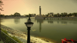
Buddha park is located in the city and is notable for its 74 ft (23 m) Buddha statue in the Abhaya posture, located in the heart of Gaja Vallivari Cheruvu tank which was used as drinking water source for Elephants in Ancient Era. Kolleru lake is a largest fresh water lake, located at a distance of about 15 km from the city. The lake is known for attracting migratory birds from Northern Europe and Northern Asia during the months of October–March. The ‘Holy Land’ of Israel has been replicated on the premises of Fr. Silvio Pasquali Memorial Convent at Duggirala on the city outskirts.[40]
Transport

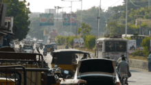
The city once named for its traffic problem with the railway gates at Vatluru, Venkatraopet, Powerpet, Old bus stand and Eastern Locks areas. When the National Highway passes through the city, the traffic hurried to pass over the railway gates in the city and outskirts, which makes taffic worse.[41] To avoid the traffic congestion, the government of India constructed a mini bypass road connecting Eastern locks and Vatluru on both ends of the city. Even then, the traffic problem could not be resolved. The main bypass road which was constructed under Golden Quadrilateral programme which was completed in late 1990’s but then only 10,000 vehicles passed through the main bypass road but now it has almost doubled.[42]
Traffic in the city of narrow lanes was growing by the day. Even though officials constructed an underbridge at Venkatraopet railway gate and a railway overbridge at old bus stand besides the foot bridge at Powerpet was replaced by another bridge but the traffic has also doubled, without giving any relief to citizens. There are 93 traffic centres identified in the city.[43]
Roadways
Eluru is well connected to the major destinations through various national and state highways. National Highway 16, a part of Asian Highway 45 and Golden Quadrilateral is a major highway that passes through a Bypass around the city and connects Kolkata and Chennai.[44] GNT Road, Mini-Bypass Road, Canal Road and Sanivarapupeta Road are the major internal arterial roads of the city. It is connected to other areas of the district by district roads and the city has a total road length of 227.09 km.[45]
Eluru is well connected to most of the cities and towns in Andhra Pradesh by road, rail and waterways. The bus, auto and railway are the main mode of transport services. APSRTC operates its bus services from Eluru Old and Eluru New bus stations[46][47] to various parts of the State and also to other states.[48] State Highway 43 and State Highway 44 connects Eluru with Sathupalli and Jangareddygudem respectively.[49][50] Private bus operators also provide transport services. Motor-driven auto-rickshaws and manual-driven cycle-rickshaws are the other alternative means of transport within Eluru. Private lorries, cars and two-wheelers are common.
Rail

Eluru is classified as an A–category station in the Vijayawada railway division of South Central Railway zone.[51][52] Apart from the main station, other stations which serve the city include, Powerpet and Vatluru. All these stations are located on Howrah-Chennai main line.
Waterways
National Waterway 4 (India) (NW-4) has been declared as an Indian National Waterway and is under development. The National Waterway 4 (India) (NW-4) runs along the Coromandal Coast through Kakinada, Eluru, Commanur, Buckingham Canal and also through part of Krishna and Godavari rivers in South India.[53]
Sports

Cricket and Soccer are the most popular sports in the city. Presently the city 🏙 has four stadium out of which Indoor Stadium, ASR Stadium hosted for Ranji Trophy in 1977. Other popular stadiums are Helapuri grounds, C.R. Reddy Cricket stadium.
Education
The city plays a major role in education for the rural students of the nearby villages.The primary and secondary school education is imparted by government, aided and private schools, under the School Education Department of the state.[54] As per the school information report for the academic year 2015–16, the city limits (including the merged villages) have more than 45,514 students enrolled in over 248 schools.[55][56] of which a total of 6519 are studying in Municipal Schools.[57]
The Central Board of Secondary Education, Secondary School Certificate or the Indian Certificate of Secondary Education are the different types of syllabus followed by different schools. The medium of instruction followed by schools are English, Telugu and Urdu.
It is home for Indian Institute of Oil Palm Research.[58] Many private residential junior colleges, high schools and technical institutions are present in Eluru. Thousands of students from various places in the district and state study in these institutions every year. They include ASRAMS, Sir C.R.Reddy Educational Institutions , Eluru College of Engineering and Technology.[59] Helapuri Institute of Technology and Engineering and NOVA Institute of Technology,Ramachandra college of engeneering, St.joseph dental college, St.theresa educational instituions.
See also
References
- 1 2 "Eluru Municipal Corporation Details". Eluru Municipal Corporation. Retrieved 20 August 2015.
- ↑ "Eluru CDMA Home".
- 1 2 "Municipalities, Municipal Corporations & UDAs" (PDF). Directorate of Town and Country Planning. Government of Andhra Pradesh. Archived from the original (PDF) on 28 January 2016. Retrieved 10 February 2016.
- ↑ "Population Statistics". Eluru Municipal Corporation. Retrieved 18 September 2015.
- ↑ "Traffic woes grip Eluru".
- ↑ "Traffic gridlock hits Eluru hard".
- ↑ "District – West Godavari". Andhra Pradesh Online Portal. Retrieved 23 August 2014.
- ↑ "West Godavari District Mandals" (PDF). Census of India. p. 439. Retrieved 19 January 2015.
- 1 2 "District Census Handbook – West Godavari" (PDF). Census of India. pp. 22–23, 54. Retrieved 18 January 2015.
- ↑ Babu, A. Satish (2008). Tourism development in India : a case study. New Delhi: A.P.H. Pub. Corp. p. 87. ISBN 978-81-313-0346-7. Retrieved 2 December 2015.
- 1 2 Unnisa, edited by Syeda Azeem; Rav, S. Bhupatthi (2013). Sustainable solid waste management (Online-Ausg. ed.). Toronto: Apple Academic Press. p. 49. ISBN 978-1-926895-24-6. Retrieved 18 September 2015.
- 1 2 "Ellore – Encyclopedia". theodora.com.
- ↑ "Controversies in History: Vengi".
- ↑ http://www.harekrsna.com/sun/features/05-15/features3456.htm
- ↑ "EASTERN CHALUKYAS".
- ↑ "Archeological Survey of India".
- ↑ Francis, W. (1 January 2002). "Gazetteer of South India". Mittal Publications – via Google Books.
- 1 2 ":: Eluru Municipal Corporation ::".
- ↑ Sr.Bimcy; Sr.Sisily; Charlotte. Bibliographic information. Scholar Publishing House. pp. 20–21. ISBN 8171725163. Retrieved 28 August 2015.
- ↑ "Climate: Eluru - Climate graph, Temperature graph, Climate table - Climate-Data.org". en.climate-data.org. Retrieved 11 May 2016.
- ↑ "Eluru City Population Census 2011 – Andhra Pradesh".
- ↑ "Eluru Population".
- ↑ "Traffic woes grip Eluru".
- ↑ "Traffic gridlock hits Eluru hard".
- ↑ "Municipalities, Municipal Corporations & UDAs" (PDF). Directorate of Town and Country Planning. Government of Andhra Pradesh. Archived from the original (PDF) on 28 January 2016. Retrieved 29 January 2016.
- ↑ "Contact Details of Commissioners and Mayors of Amrut Cities" (PDF). Atal Mission for Rejuvenation and Urban Transformation. Government of India. Retrieved 28 March 2016.
- ↑ Sandeep Kumar, S (10 August 2015). "Small towns fare better in Swachh Bharat rankings". The Hindu. Vijayawada. Retrieved 30 March 2016.
- ↑ "Territorial Jurisdiction of Criminal Courts". Official Website of District Court of India. Retrieved 12 January 2016.
- ↑ "MLA". AP State Portal. Retrieved 18 September 2015.
- ↑ "MP (Lok Sabha)". Government of AP. Retrieved 4 May 2015.
- ↑ "Delimitation of Parliamentary and Assembly Constituencies Order, 2008" (PDF). Election Commission of India. p. 20,30. Retrieved 11 October 2014.
- ↑ "Pawan Kalyan to open office in Eluru soon".
- ↑ Nagaraja, G (20 March 2014). "Handmade carpet industry in doldrums". The Hindu. Retrieved 26 November 2015.
- ↑ Sajnani, Manohar (2001). Encyclopaedia of tourism resources in India. New Delhi: Kalpaz Pub. p. 66. ISBN 978-81-7835-018-9. Retrieved 26 November 2015.
- ↑ "Lack of parking lots causes severe traffic snarls".
- ↑ "Ambica Agarbathies". Retrieved 14 March 2016.
- ↑ Eluru people as Elurians.
- ↑ Nagaraja, G (16 April 2014). "Antique museum at Eluru soon". The Hindu. Eluru. Retrieved 2 March 2016.
- ↑ "Entertainment in Eluru". eluru.
- ↑ "'Holy Land' thrown open to public". 29 January 2014 – via The Hindu.
- ↑ "Old overbridge bearing brunt of growing traffic".
- ↑ "Traffic woes grip Eluru".
- ↑ "Traffic gridlock hits Eluru hard".
- ↑ "National Highways in A.P". AP Online Portal. Retrieved 4 August 2014.
- ↑ "Details of Roads in each ULB of Andhra Pradesh". Municipal Administration and Urban Development Department. Retrieved 27 June 2016.
- ↑ "Bus Stations in Districts". Andhra Pradesh State Road Transport Corporation. Retrieved 8 March 2016.
- ↑ "Eluru old bus stand in bad shape". Eluru. 26 May 2006. Retrieved 15 March 2016.
- ↑ "RTC buses go off the road".
- ↑ "Brief of Roads". Roads and Buildings Department. Government of Andhra Pradesh. Retrieved 22 February 2016.
- ↑ "Old overbridge bearing brunt of growing traffic".
- ↑ "Divisional info" (PDF). Indian Railways. Retrieved 10 February 2016.
- ↑ "Eluru railway station info". India Rail Info. Retrieved 26 November 2015.
- ↑ "Speed up Aquisation for Inland waterways".
- ↑ "School Education Department" (PDF). School Education Department, Government of Andhra Pradesh. Retrieved 7 November 2016.
- ↑ "R1.1 SCHOOL INFORMATION".
- ↑ "Student Information Report". Commissionerate of School Education. Child info 2015-16, District School Education - Andhra Pradesh. Retrieved 8 November 2016.
- ↑ "MUNICIPAL CORPORATION, ELURU-SCHOOL WISE STUDENT DETAILS" (PDF).
- ↑ "Location map" (PDF).
- ↑ "Welcome! Eluru College of Engineering & Technology : Eluru". ecet.ac.in.
External links
| Wikimedia Commons has media related to Eluru. |
- Eluru Municipal Corporation website
-
 "Ellore". Encyclopædia Britannica (11th ed.). 1911.
| Topics | 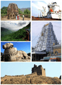 | |
|---|---|---|
| Regions | ||
| Districts | ||
| Million-plus cities | ||
| Cities (population over 1 lakh) | ||
| Tourism |
| |
| Related lists |
| |
| ||