Geography of Andhra Pradesh

Andhra Pradesh lies between 12°41' and 19.07°N latitude and 77° and 84°40'E longitude, and is bordered by Telangana, Chhattisgarh, and Orissa in the north, the Bay of Bengal in the East, Tamil Nadu to the south and Karnataka to the west. Among the other states, which are situated on the country's coastal area, Andhra Pradesh has got a coastline of around 972 km, which gives it the 3rd longest coastline in the nation.[1] Two major rivers, the Godavari and the Krishna run across the state. A small enclave 12 sq mi (30 km²), the Yanam district of Puducherry, lies in the Godavari Delta in the north east of the state. The state includes the eastern part of Deccan plateau as well as a considerable part of the Eastern Ghats.
Historically the region comprising the state was known as Andhraapatha, Andhradesa, Andhraavani, and Andhra vishaya.[2]
Climate
The climate of Andhra Pradesh is generally hot and humid. The summer season in this state generally extends from March to June. During these months the moisture level is quite high. The coastal areas have higher temperatures than the other parts of the state. In summer, the temperature generally ranges between 20 °C and 40 °C. At certain places the temperature is as high as 45 degrees on a summer day.
The summer is followed by the monsoon season, which starts during July and continues till September. This is the season for heavy tropical rains in Andhra Pradesh. The major role in determining the climate of the state is played by South-West Monsoons. About one third of the total rainfall in Andhra Pradesh is brought by the North-East Monsoons around the month of October in the state.
The winters in Andhra Pradesh are pleasant. This is the time when the state attracts most of its tourists. October to February are the winter months in Andhra Pradesh. Since the state has quite a long coastline,[3] the winters are comparatively mild. The range of winter temperatures is generally from 13 °C to 30 °C.
Locals and tourists generally find that cotton summer clothes are best suited to coping with the climate of Andhra Pradesh.
Divisions
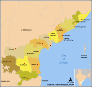
Andhra Pradesh can be divided into two regions, namely Coastal Andhra and Rayalaseema.[4]
Andhra Pradesh has 13 districts: Anantapur, Chittoor, Kadapa, East Godavari, Guntur, Krishna, Kurnool, Sri Potti Sreeramulu Nellore, Prakasam, Srikakulam, Visakhapatnam, Vizianagaram and West Godavari.
Anantapur is the largest district of the state and the 7th largest district in India with an area of 19130 km2.
Each district is divided into multiple mandals, and each mandal has many villages.
Visakhapatnam is the largest city in the state followed by Vijayawada. Other important cities and towns are Kakinada, Guntur, Rajahmundry, Tirupati, Nellore, Ongole, Kurnool and Eluru.
New capital
After Telangana was created on 2 June 2014, Andhra Pradesh's erstwhile capital Hyderabad remained in Telangana. Although Hyderabad was set to remain the joint capital of both states for ten years, the new capital is being built at Amaravati.[5]
Notes
- ↑ "Andhra Pradesh Fact File" (PDF). AP State Portal. Retrieved 16 July 2014.
- ↑ S. S. Ramachandramurthy (1995). A Study of Telugu Place-Names. Delhi: Agam Kala Prakashan. p. 10.
- ↑ "Andhra Pradesh Information". Centre for Coastal Zone Management and Coastal Shelter Belt. 2014-09-04. Retrieved 2014-09-26.
- ↑ AP Cabinet approves four regional planning boards.
- ↑ "The Andhra Pradesh Reorganisation Act, 2014" (PDF). India Code Legislative Department. Ministry of Law and Justice. 1 March 2014. p. 2. Retrieved 14 July 2015.
External links
| Wikimedia Commons has media related to Geography of Andhra Pradesh. |
| Topics |  | |
|---|---|---|
| Regions | ||
| Districts | ||
| Million-plus cities | ||
| Cities (population over 1 lakh) | ||
| Tourism |
| |
| Related lists |
| |
| ||